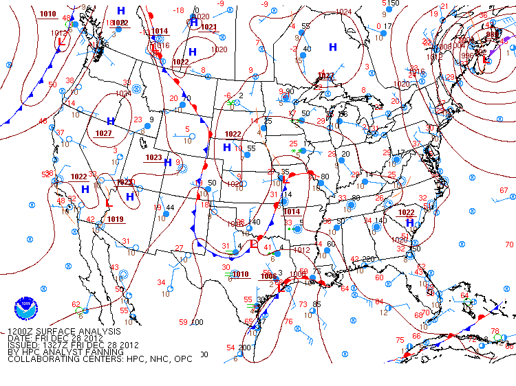
Monday, December 31, 2012

Winter '12 / '13 - Storm #2: Final Results

1st - donsutherland1
SUMSQ:
77.41

SUMSQ Z:
-1.049

STP:
13.15
 (5)
TAE:
30.45
 (1)
AAE:
1.45
 (2)


2nd - Brad Yehl
SUMSQ:
78.27

SUMSQ Z:
-1.040

STP:
10.15
 (4)
TAE:
31.05
 (2)
AAE:
1.29
 (1)
3rd - snocat918
SUMSQ:
104.51

SUMSQ Z:
-0.752

STP:
7.55
 (3)
TAE:
39.55
 (5)
AAE:
1.72
 (4)


HM - Donald Rosenfeld
SUMSQ:
112.59

SUMSQ Z:
-0.663

STP:
1.10
 (1)
TAE:
40.20
 (6)
AAE:
1.83
 (6)


SUMSQ: sum of square errors
STP: storm-total precipitation error
TAE: total absolute error
AAE: average absolute error
(number):  category rank

Full forecast verification and summary at the Contest/s home page.

Sunday, December 30, 2012

Winter '12 / '13 - Storm #1: Final Results


1st - dryslot
SUMSQ:
112.98

SUMSQ Z:
-0.887

STP:
5.26
 (4)
TAE:
39.64
 (6)
AAE:
1.80
 (5)
2nd - herb@maws
SUMSQ:
119.42

SUMSQ Z:
-0.846

STP:
13.79
 (7)
TAE:
36.79
 (3)
AAE:
1.75
 (3)
3rd - Brad Yehl
SUMSQ:
213.38

SUMSQ Z:
-0.782

STP:
2.65
 (3)
TAE:
35.75
 (2)
AAE:
1.62
 (2)
HM - Donald Rosenfeld
SUMSQ:
140.87

SUMSQ Z:
-0.711

STP:
0.99
 (1)
TAE:
33.99
 (1)
AAE:
1.55
 (1)

SUMSQ: sum of square errors
STP: storm-total precipitation error
TAE: total absolute error
AAE: average absolute error
(number):  category rank

Full forecast verification and summary at the Contest/s web site.

Winter '12 / 13 - Storm #2: Preliminary Verification


Preliminary storm-total snowfalls for Saturday from CDUS41 and CXUS51 bulletins.

Several stations in the data table do not have SN:H2O reported b/c their liquid totals included mixed precipitation.

CON STP of 2.6" at 10:1 is suspect given surrounding amounts and much higher ratios.

---
Two new daily records.
SAT...29-DEC-12
BDR - 3.5" (3.1"; 1959)
IAD - 0.9" (0.3"; 1993)

---
Please report any errors and drop a link to the correct data in Comments.

Final results and storm summary Monday evening.

Saturday, December 29, 2012

Winter '12 / '13 - Storm #2: The Forecasts

Consensus for a southern NE and northern M-A event.


12 forecasters
3 Rookies...two of which issued their 1st forecast for Storm #2.

Welcome Kevinmyattwx and quagmireweathercentral!
Forecaster answer7 is now an Intern.


Forecasts are ranked by their storm-total precipitation (STP).
BLUE ==> 25th percentile.
RED ==> 75th percentile.
STP cells without color are between the 25th and 75th percentile.

Everyone/s station-by-station forecast at the Contest/s web site.

---

Slight amplification in the long-wave flow regime suggested by +PNA.  -AO getting the job done again as its sister index the +NAO offers more evidence of how unimportant she is to snowfall on the east coast.

Winter '12 / '13 - Storm 1: Preliminary Verification


Preliminary storm-total snowfalls for Wednesday through Friday from CDUS41 and CXUS51 bulletins.

Several stations in the data table do not have SN:H2O reported b/c their liquid totals included mixed precipitation.

SN:H2O for CON appears low in light of METARs reported only SN.

---
Two new daily records.
THU...27-DEC-12
PWM - 11.6" (8.8"; 1894)
CAR - 6.2" (6.2"; 2010)

---
Please report any errors and drop a link to the correct data in Comments.

Final results and storm summary Sunday evening.

Friday, December 28, 2012

Winter '12 / '13 - Storm #2: RAW Forecasts


NYC - 5th Avenue
1905
RAW forecasts here.

# Forecasters: 12
Two fresh Rookies.

Marginal event but what the hay.  Best case scenario...the plows will be out on the road.

In hindsight...should have left the verification period open ended.  When the 'Call for Forecasts' was issued on THU...NWP indicated most of the snow would have fallen by 11:59 PM SAT.  Later guidance suggested otherwise.

Storm #2 forecast summary and all individual forecasts will be posted to the Contest/s web log and / or web site by Saturday evening.

Thursday, December 27, 2012

Winter '12 / '13 - Storm #2: Call for Forecasts!

NYC
27-DEC-47

Another Miller A-B hybrid storm heading toward the forecast area.

Southern stream LOW forms in the Gulf of Mexico.  Second decaying LOW INVOF the Great Lakes drifting east in the northern stream.

Stronger GOM LOW captures the Lake's LOW over the western M-A.  Rapid deepening near the 40/70 benchmark late in the period as the storm kicks out to sea.  Mainly a rain event over the water and contest-worthy snows over the northern M-A and SNE.

Storm #2 potential appears marginal at post time where the best case scenario produces widespread plowable snowfall; however...there are equal chances for widespread nuisance amounts.

The forecast contest for Storm #2 may be canceled prior to deadline if NWP indicates a fizzling event.

---
Forecast element: storm-total snowfall
Deadline for entries: 10:30 PM EST FRI...28-DEC-12

Verification period begins: 12:01 AM SAT...29-DEC-12
Verification period ends: 11:59 PM SAT...29-DEC-12

Enter your forecast at the Contest's home page here.
Follow the link from 'Enter Storm Forecast.'

---
As always...there/s no cost...or fee...or advertising...or annoying requests for personal information to enter a forecast. It's just a fun exercise for winter wx enthusiasts to see who can make the best synoptic-scale snowfall forecast.

If you are issuing your first forecast this winter...or you entered the 'season-total' forecast contest...you/ll need to create an account (user name / password / valid e-mail...if you want a copy of your forecast sent to your Inbox).
---

Want to be notified via e-mail when the 'Call for Forecast' is issued?
Send requests to 'newx at newx-forecasts dot com'.

Wednesday, December 26, 2012

Winter '12 / '13 - Storm # 1: The Forecasts

Consensus for this season/s inaugural event has bonus snows for New England/s northern stations and crumbs for most inland locations along the mid-Atlantic.  The eight to 10 stations in play makes this a decent synoptic-scale winter storm despite rain for major cities along the I-95 corridor.


13 forecasters
11 veterans and 2 Rookies


Forecasts are ranked by their storm-total precipitation (STP).
BLUE ==> 25th percentile.
RED ==> 75th percentile.
STP cells without color are between the 25th and 75th percentile.

Everyone/s station-by-station forecast at the Contest/s web site.

---
Roger Smith is promoted to Senior forecaster this year.
Brad Yehl is now a Journeyman forecaster.
Dryslot is an Intern.

Forecaster status - Years Experience
Rookie - 0
Intern - 1
Journeyman - 2
Senior - 3
Chief - last year/s 'Regular' season contest winner.

---


PNA at long last comes out of its long coma and a good looking AO although a fair case can be made the state of these indices played a relatively minor role.

Tuesday, December 25, 2012

Winter '12 / '13 - Storm #1: RAW Forecasts

Maine mill pond
12-28-1951
RAW forecasts posted at NEWxSFC/s GoogleGroup here.

# Forecasters: ~13
Welcome back Vets and welcome aboard to the one or two Rookies.

Where a forecaster issued more than one forecast...only the last one is verified.

Storm #1 forecast summary and all individual forecasts will be posted to the Contest/s web log and / or web site sometime Wednesday.

---
Progs suggest an active period over the next week or two...so keep them pencils sharp!

Winter '12 / '13 - January 2013: Week One Outlook


From today/s PSD GFS ensembles...Week 2 anomaly forecasts (VT centered on 05-JAN-13).

---
Area 1 depicts the Pacific/s polar jet at 250 mb riding up and over PNA ridge.

Area 2 is the sub-tropical jet (STJ) phasing with the polar jet over the upper MIssissippi river valley.

Area 3 is the negative height anomaly at 500 mb located over New Foundland...CN

Area 4 shows the 850 mb temperature anomaly drawing high-latitude cold air into the NE on the backside of the Newfoundland LOW and the warm advection onto the Greenland ice sheet which in turn would induce or strengthen a blocking HIGH and negative northern annular oscillation indexes (AO; NAO).

Area 5 highlights precipitation anomalies from Mexico to the mid-Atlantic states aligned with the STJ axis.  Note the northern edge of the anomaly coincides with negative 850 mb temperature anomalies.

Amplified flow + short wave energy + cold air + moisture = forecast for snow

Monday, December 24, 2012

Winter '12 / '13 - Storm #1: Call for Forecasts!

NYC
14-JAN-1915

Today/s 12z GFS progs indicate a fair number forecast stations across the mid-Atlantic and southern New England are in line to get more than nuisance snows making this season/s premiere event a contest-worthy storm.

Miller A-B hybrid storm expected to spawn in the Gulf of Mexico INVOF KBRO on Christmas Day...then move into western TN beneath the eastern extension of a 1033 HIGH over James Bay.

Weak re-development on the southern mid-Atlantic coast coast near the VA Capes late Wednesday followed by a track up the NE coast.  Poor upper-level support suggested by the open wave at 5H and little if any height falls throughout the forecast period.

Mainly a rain event with snow on the northern edge of the cloud shield and a broad transition zone of mixed precipitation.

The contest may be canceled prior to the deadline if NWP indicates a fizzling event.

---
Forecast element: storm-total snowfall
Deadline for entries: 10:30 PM EST TUE...25-DEC-12

Verification period begins: 12:01 AM WED...26-DEC-12
Verification period ends: 11:59 PM FRI...28-DEC-12

Enter your forecast at the Contest's home page here.
Follow the link from 'Enter Storm Forecast.'

---
As always...there/s no cost...or fee...or advertising...or annoying requests for personal information to enter a forecast. It's just a fun exercise among winter wx enthusiasts to see who can make the best synoptic-scale snowfall forecast.

If you are issuing your first forecast this winter...or you entered the 'season-total' forecast contest...you/ll need to create an account (user name / password / valid e-mail...if you want a copy of your forecast sent to your Inbox).

---
Want to be notified via e-mail when a 'Call for Forecasts' is issued?
Send requests to 'newx at newx-forecasts dot com'.

Winter '12 / '13 - Coastal Teaser #1

UPDATE:
Today/s 12z precip-type prog @VT90 trending 'NO GO'.
Blocking HIGH is keeping the storm close to shore.

No longer a weakness up the coast indicated @VT132.


---
Signs of life at 132 hours from today/s 12z GFS...


Storm originates in the Gulf of Mexico Tuesday then moves NE along the western slopes of the Applachain mountains and re-develops off the Delmarva coast on Wednesday.

Should this come to pass...the 'Call for Forecasts' would be issued Monday evening with a deadline for entries Tuesday evening at 10:30 PM.

Saturday, December 22, 2012

Winter '12 / '13 - The Change


A pattern change appears to be finally in the works as a stable...four wave flow regime with an anti-cyclone parked over the Pole sets up by D+10.

Initial state starts with the 'never-say die' blocking ridge over the Bering Sea and a deep trof in the Gulf of Alaska where SSTAs are below normal thanks to the PDO.

These two persistent teleconnection features have kept the PNA underwater for months...wasting the cold air potential of a negative AO and its sister index..the NAO.

---
All that is forecast to change in 10 days as the Bering Sea HIGH becomes pinched off and shoved to a position directly over the Pole...where its circulation is re-enforced by the flow around four trofs at lower latitudes.

 The Gulf of Alaska LOW is replaced by the PNA ridge....achored by a cut-off LOW offshore of SOCAL.  The ridge delivers cold air and short-wave energy embedded in the Polar jet stream into the Lower 48 where it has opportunities to phase with short-wave energy ejecting from the cut-off LOW and moisture transport y the sub-tropical jet stream.

This scenario was more-or-less forecast by PSD's GFS '8-14 day' ensembles earlier in the month altho the model had the change in place about ten days too soon.

Even the GFS shows large chunks of arctic air reaching the Gulf of Mexico and Miller 'A' storms moving along the east coast.

---
Images courtesy Plymouth State Wx

Sunday, December 16, 2012

Winter '12 / '13 - Arctic Oscillation: Meteorological Winter - Day 15

Not sure what if anything it means but here's the state of the AO on Day 15 of meteorological winter during its 63 year period-of-record.


Blue line is the observed AO on 15-DEC.
Red line is a 9-point binomial filter.  The filter removes noise from the signal to highlight trends.

The 15-DEC-12 AO ranks 19th (25th percentile).


Same idea for AO/s sister...the North Atlantic Oscillation (NAO).
The 15-DEC-12 NAO ranks 36th (57th percentile).

Friday, December 14, 2012

Winter '12 / '13 - Mid-DEC Snow Scenes

Times Sq
13-DEC-33

NYC
13-DEC-60


Haverhill...MA
12/13-DEC-1890

Haverhill...MA
14-DEC-1890


Wednesday, December 12, 2012

Winter '12 / '13 - White Christmas


White Christmas in the US is defined as 1" on-the-ground on 25-DEC.  The criteria are different in other countries.

The probability of an event is determined by dividing the number of times something happened in the past by the number of times it could have happened.

If there was a white Christmas five times over 20 years...the probability is 25% in any given year.

---
Folklore predictions...
- A green Christmas; a white Easter.

- If there's thunder during Christmas week...
The Winter will be anything but meek.

- The nearer the New Moon to Christmas Day...the harder the Winter.
[ed:  New moon 13-DEC-12]

- If Christmas day be bright and clear
There’ll be two winters in the year.

- Thunder in December presages fine weather.

- Like in December like all the year long.

Winter '12 / '13 - Go to Sleep and Dream of Snow

Repost from JAN-07...

---
Snow
It won't be long before we'll all be there with snow
Snow
I want to wash my hands, my face and hair with snow

Snow
I long to clear a path and lift a spade of snow
Snow
Oh, to see a great big man entirely made of snow


Where it's snowing
All winter through
That's where I want to be
Snowball throwing
That's what I'll do
How I'm longing to ski
Through the snow-oh-oh-oh-oh


Those glist'ning houses that seem to be built of snow
Snow
Oh, to see a mountain covered with a quilt of snow

What is Christmas with no snow
No white Christmas with no snow
Snow

I'll soon be there with snow
I'll wash my hair with snow
And with a spade of snow
I'll build a man that's made of snow
I'd love to stay up with you but I recommend a little shuteye
Go to sleep
And dream
Of snow

Monday, December 10, 2012

Winter '12 / '13 - AER Goes All In for Eastern Cold


Based on Eurasian snow cover in October:  Ridge-W / Trof-E!

From OurAmazingPlanet...

...the model forecasts cold weather through February for the United States from the Rockies to the East Coast, Cohen said...last week at the annual meeting of the American Geophysical Union.

...cold-hardy Alaskans are complaining about the unusually bitter weather so far, counter to the model's prediction. An omega block, a center of atmospheric pressure sitting over the Bering Sea, is keeping the state at below-freezing temperatures. According to the National Weather Service, November 2012 was the sixth-coldest November for Fairbanks on record.

"When the Arctic Oscillation is negative, as it is now, Alaska is supposed to be warm, but it's not...  The North Pacific seems to be doing something separate from what would normally happen," said Cohen.
More...
Cohen/s AGU conference presentation abstract here.

Winter '12 / '13 - Siberian Express


The ECMWF has been advertising a significant cold intrusion into the lower 48 over the past few runs...along with a cross-polar shift of the polar vortex from Baffin Bay toward a position INVOF the south Kara Sea bordering northern Russia.

The yellow region on the map marks the location of 'warm' air at 100 mb.  This area is also where low heights in the troposphere are found.

This Siberian visitor should be enough to change the long wave flow regime just in time for the holidays.

Saturday, December 8, 2012

Winter '12 / '13 - Eurasia Snow Cover: November

Actual:  22,031,257 km2
Normal:  20,334,319 km2

Eurasia/s November snow cover was one standard deviation (dashed yellow line) and 8% above normal.  Second year in a row November was above normal.


Blue - observations
Red - 9-point binomial filter
Orange - median
Dash yellow - one standard deviation

---
Eurasian snow cover and departure from its median year-to-date.
July/s snow cover was 84% below normal.


October/s charts here.
Raw data here.

Thursday, December 6, 2012

Winter '12 / '13 - Stratospheric Sudden Warming: Watch #1


UPDATE2:  Earlier suggestions of a fizzled SSW event appears to have fizzled.  No long lasting effects are expected from this short-lived event; however...the PV did reverse course as forecast.

Warm colors shown on the stage-right image from the Japan Meteorological Agency (JMA) depict easterly wind flow.  East winds over the Pole means an anti-cyclone has replaced the normal cyclonic circulation associated with the PV.

---
UPDATE:  Earlier suggestions of a SSW event appears to have fizzled.

Forecasts of a split PV @100 mb peaks during the next day or two followed by a return to a single vortex center and a return to deep-layer cyclonic flow over the Pole.

---
The ECMWF continues to depict a sudden stratospheric warming event during late November into early December.

The polar vortex (PV) is forecast to begin splitting in two at 100 mb early next week with distinct centers of circulation over Victoria Island...CN and south-central Russia by 03-DEC.

The effects would be felt at the surface in about three weeks if this feature develops as forecast.

Deep layer easterlies are also progged over high latitudes by D+10 indicating the presence of an Arctic anticyclone.


The QBO is in the waning stage of its easterly cycle such that the PV is already in a 'weakened' state.  Major winter stratospheric warmings preferentially occur during the easterly phase of the QBO. Holton and Tan (1980)
The QBO determines the character of the early winter, leading to a colder and more stable polar vortex in December and January during the west phase of the QBO and a more disturbed and warmer Arctic during the east phase of the QBO.(1)
From Thompson et. al...
Pronounced weakenings of the NH wintertime stratospheric polar vortex tend to be followed by episodes of anomalously low surface air temperatures and increased frequency of occurrence of extreme cold events throughout densely populated regions such as eastern North America, northern Europe, and eastern Asia that persist for ~2 months.(2)
The Arctic Oscillation (AO) is heading for a cliff.  The GFS forecast takes the AO on a deep dive where it remains negative through D+10.

Winter '12 / '13 - Blocking

Blocking forecast to shift from Bering Sea to Greenland by mid-month!


That...and no evidence of the Gulf of Alaska LOW...heralds winter/s over-due arrival on the east coast.

Winter '12 / '13 - North Atlantic Oscillation - Analog Update

NOV/s NAO index:  -0.58


A 2x2 contingency analysis suggests there/s a 57% probability for the NAO index to average negative during meteorological winter (D-J-F) when NOV/s NAO is negative.

Top analog remains 1998...an el Niño winter.  QBO was fading out and flipped from east to west in JAN.  AO averaged positive.  Not good if it comes to pass given winter/s NAO also averaged positive.

Up one tick are 2008 and 2003...the latter being a good match as AO/s top co-analog along with QBO...and a strong showing by SOI.  ENSO was a warm Nada.  DC measured a paltry 13" and RIC 6".  The good snows that winter were in mainly in south coastal NE and the northern M-A [PVD (119%)...BDR (189%)...BGM (137%)...NYC (155%)...ABE (124%)...EWR (177%)...and RDU (199% from a late season low-latitude thump)].

Season-total snowfall at NEWxSFC Contest stations during Winter '03 / '04 totaled 999"...8" above period-of-record normal (PoRN).

None of the analog years look particularly promising  b/c almost all go positive in JAN and FEB.  Negative NAO falls into the nice-to-have category but it's not all that important for it to be in such a constant state.