|
Route 128
Danvers...MA
10-FEB-69 |
The last 'Call for Forecasts' came 41 days ago. What a crappy winter!
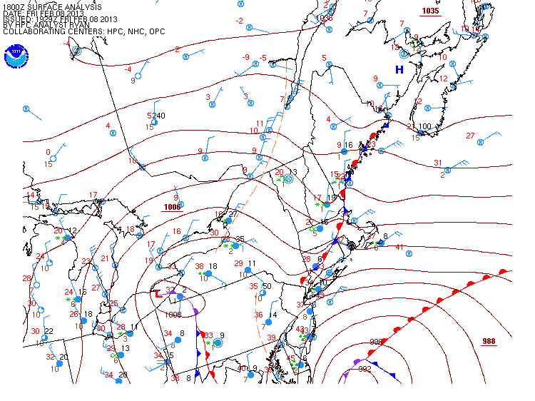
NWP offering up another odd Miller A / B hybrid with explosive development along the SNE coast...near-blizzard conditions...and a track over the famed' benchmark' at 40°N / 70°W.
This go-round it's an actual real-live snowstorm and not some poser LOW with a thin strip of snow on the northwestern edge of the precipitation shield.
The forecast contest for Storm #3 may be canceled prior to deadline if NWP indicates a fizzling event altho that seems unlikely.
---
Forecast element: storm-total snowfall
Deadline for entries: 10:30 PM EST THU...07-FEB-13
Verification period begins: 12:01 AM FRI...08-FEB-13
Verification period ends: when the snow stops*
Enter your forecast at the Contest's home page
here.
Follow the link from 'Enter Storm Forecast.'
---
As always...there/s no cost...or fee...or advertising...or annoying requests for personal information to enter a forecast. It's just a fun exercise for winter wx enthusiasts to see who can make the best synoptic-scale snowfall forecast.
If you are issuing your first forecast this winter...or you entered the 'season-total' forecast contest...you/ll need to create an account (user name / password / valid e-mail...if you want a copy of your forecast sent to your Inbox).
---
Want to be notified via e-mail when a 'Call for Forecasts' is issued?
Send your request to 'newx at newx-forecasts dot com'.
---
* Current NWP suggests accumulating snows coming to an end Saturday evening.
Verification period may end 11:59 PM SAT...09-FEB-13 even if light snowfall is occurring over a station or two. No reason to hold up the preliminary verification report to count 12 extra snowflakes somewhere.