Snow Storm #4: Preliminary Verification
 Preliminary storm-total snowfalls from CDUS41...PNS...and CF6 bulletins for Wednesday and Thursday.
No new daily records.
Please report errors in Remarks.
Final results and storm summary Saturday.
Preliminary storm-total snowfalls from CDUS41...PNS...and CF6 bulletins for Wednesday and Thursday.
No new daily records.
Please report errors in Remarks.
Final results and storm summary Saturday.
 A genuine snow storm appears in the offing this weekend. Not the 'some snow on the northern edge of the precipitation shield' that has been so common so far this season. After the way Snow Storm #4 fizzled...the atmosphere owes us one.
Make the best forecast and you/ll win one month of FREE access to StormVista GOLD. Details here.
Deadline: Friday...09 January...2009 @ 10:30 PM EST
Forecast element: storm-total snowfall
Verification period begins: 12:01 AM EST Saturday...10 January 2009
Enter your forecast here.
Follow the link from 'Enter Storm Forecast.'
More prizes will be awarded at the end of winter for the best over-all forecaster. Details here.
As always...there/s no cost...or fee...or annoying requests for personal information to enter.
If you are making your first forecast this year or you entered the 'season-total' forecast contest...you/ll need to create an account (user name / password / valid e-mail...if you want a copy of your forecast sent to your Inbox) before entering a forecast.

16 forecasters...including 4 rookies...for the season/s fourth storm.
Station forecasts here.
Northern stations continue to get the best of it again this winter.
-NAO pulling its weight...again.
Verification began last night at 12:01 AM EST. Snowfall continues over the forecast area at post time and is expected to continue into early Thursday afternoon. Preliminary storm-total snowfalls will be posted Thursday evening with the final results available on the web site Friday evening.
 The short-wave progged to affect the forecast area Saturday appears well south of the Aleutian Islands on GOES-W this evening. It/s heading for shore in the PAC NW THU afternoon. GooFuS phases / amplifies this feature on Friday over the Great Lakes with remnants of a weakening upper LOW currently atop AK.
Saturday is still aways away; however...this storm...as currently depicted...has good upper air support (PVA; left exit-region of lifting jet max) for dynamic cooling and strong warm-air advection at 85H. The omega equation couldn/t be happier.

 Monday/s 00z NAM is dangling dendrites over the forecast area on Wednesday.
CON f-sounding ==>
Model predicts 18 hours of precipitation over southern NH...where the moist column depth is below 0°C and nine 'stellar' hours where the cloud top temperature is ~15°C.
First flakes are still aways out; however...even some interior mid-Atlantic stations may be in play for this storm.
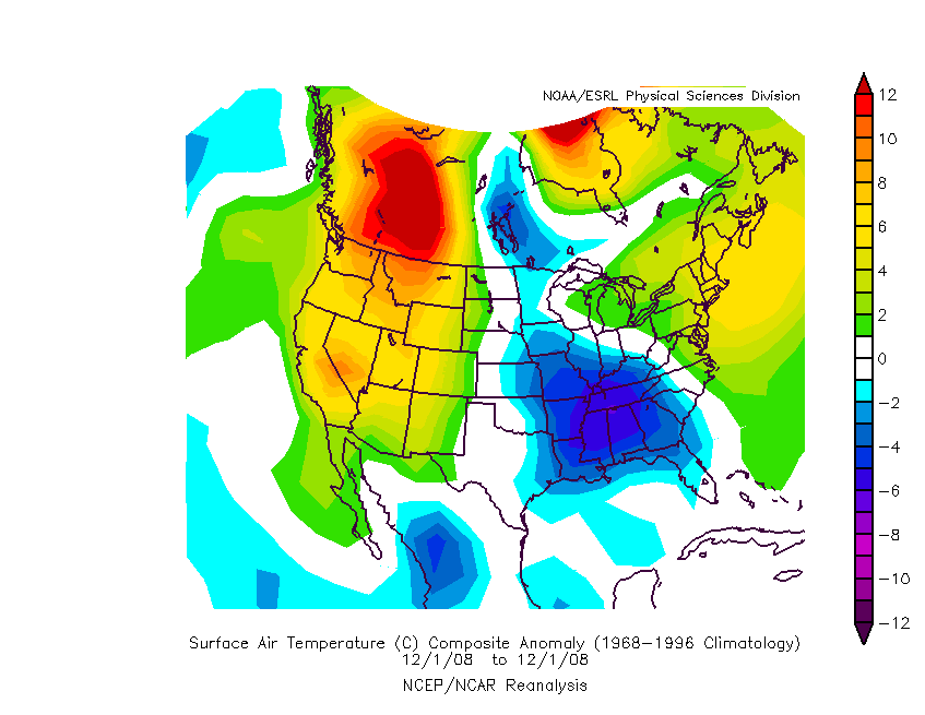
 A notably...nay brutally...cold December was heralded for the eastern CONUS by many well-known LR wx forecasters as meteorological winter approached.
Offered for your consideration...a cumulative temperature departure animation for NOAM here.
Northeastern CONUS temperatures never did observe negative anomalies...nor did the mid-Atlantic region except for a brief period centered around the 8th. The negative anomaly centroid was over the SE for much of the month before retrograding into the upper Plains.
End-of-month snapshot of precipitation departures.
Note main storm track running NE through MO - IL - MI and secondary axis from MS - TN - WV continuing into New England.
The primary storm track is at odds with the statistical correlation between 'NAO - precipitation.' The map below indicates when NAO is positive the storm track runs from MO - IL - MI...as observed during December. Problem is...the daily average NAO for December was -0.281.
The ten-year NAO precipitation correlation time period was selected b/c it excludes the +PDO / +ENSO years that dominated the late 80s and early 90s. The correlation coefficient must be at least +/- 0.6 to be statistically significant.

December/s storm track was quite favorable for southern New England stations where Bridgeport (BDR) and Boston (BOS) observed more than triple their normal monthly snowfall.
Four other stations (Providence...Bangor... Worcester...and Burlington) measured at least twice their long-term average.
December snowfall at five stations was more than 50% of their normal season-total (D-J-F-M) snowfall.
Biggest losers were in the mid-Atlantic region...as was the case last season.


