Monday, December 11, 2023

Winter '23 / '24 - 23rd Annual 'Season-total' Snowfall Forecast Contest: The Forecasts!


NYC - Rockefeller Plaza
26-DEC-47
All forecasts at Contest/s web site. (direct link to forecast data table here).

---
Welcome and Good Luck to All 🍀🍀🍀

Senior NEWxSFC forecaster snowman ... having made the best 'season-total' snowfall forecast for Winter '22 / '23 ... is back this year to defend his 'Chief Season-total Forecaster' title.

Forecasters also compete against the Period-of-Record Normal (P-O-R-N) and CONSENSUS.

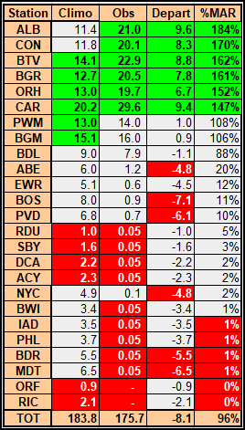
Table below rank-orders forecasts by ascending season-total snowfall.

BLUE - Quartile 1
RED - Quartile 4
ORANGE - Winter '23 / '24's Chief 'Season-total' forecaster

P-O-R-N - Period-Of-Record Normal
CONSENSUS - average forecast for each station

Forecasts submitted with decimal values have been recorded as such for verification;  however ... rounding was applied for display purposes only.

---
Forecasters:  22
Total station forecasts:  550 (excluding P-O-R-N & CONSENSUS)

All forecasts at the Contest/s web site. (direct link to forecasts here).

Thursday, November 30, 2023

Winter '23 / '24 - 23rd Annual 'Season-total' Snowfall Forecast Contest: Call for Forecasts!

NEWxSFC/s
Director of Season-total Snowfall Forecasting
NEWxSFC runs the longest continuously held snowfall forecasting contests on the World Wide Web.

Our 23nd annual ‘season-total' snowfall forecast contest is a great opportunity to demonstrate your long-range forecasting acumen ... and if you get lucky ... win some books about meteorology ... too.

And it's really easy.
All you have to do is predict the 'season-total' snowfall at 25 stations across the mid-Atlantic and New England from Raleigh ... NC (RDU) to Caribou ... ME (CAR).

If you're new to season-total snowfall forecasting ... start off with climatology and go from there.

Visit the Contest's website to enter your forecast.

Saturday, April 8, 2023

Winter '22 / '23 - 24th Annual 'Regular Season' Snowfall Forecast Contest: FINAL Results

After FOUR contest-worthy snow storms ... under the ‘two-thirds’ rule … forecasters who entered at least THREE forecasts are included in this season's FINAL standings.

Full table with all other error statistics at the Contest/s web site here (direct link).

Individual forecaster's storm statistics here (direct link).

Wednesday, April 5, 2023

Winter '22 / '23 - 22nd Annual 'Season-total' Snowfall Forecast Contest: FINAL Results

NYC ... 5th Ave.
Alfred Stieglitz.(1892)
Congratulations to snowman for issuing the best season-total snowfall forecast for Winter '22 / '23.

Complete forecaster verification table at the Contest web site.
http://www.newx-forecasts.com/NEWxSFC_24/season-total/season_total_verification_2223.htm

Forecasters ranked ascending by their Total Absolute Error (TAE).

BLUE ==> 1st Quartile
WHITE ==>  Interquartile range
RED ==> 4th Quartile
ORANGE:  Winter '22 / '23 Chief 'Season-total' Forecaster (winner of  '21 / '22 contest)

The '%MPRV over PORN' metric indicates how much the forecast was an improvement over Period-Of-Record-Normal (PORN).  Skillful forecasts beat PORN.

Tuesday, April 4, 2023

Winter '22 / '23 - 'Season-total' Snowfall Forecast Contest: MAR Snowfall Totals

Woodstock ... VT (c.1890)
CORR:  snowfall at CON should be 20.4"
Departure:  8.6"
%MAR:  173%

MAR-23 snowfall summary by forecast station.
Rank ordered descending by percent of monthly period-of-record-normal (P-O-R-N).

Green ==> 4th quartile
White ==> less than 4th and greater than 1st quartile (inter-quartile range)
Red ==> 1st quartile

'Obs' reporting '0.05' denote 'Trace' amounts (observed but unmeasurable).

---
MAR Forecast Station Highlights

8 northern tier stations exceeded their monthly snowfall climatology.

Biggest Losers
9 stations observed trace amounts.
2 stations not a single flake ... ice pellet ... or hailstone observed.

---
Season-Total-to-Date
MAR P-O-R-N contributes 184" (20%) toward the season-total (D-J-F-M) snowfall of 934".
MAR-23 observed snowfall:  176" (96% of monthly P-O-R-N; 19% of normal season-total snowfall).

Image courtesy NOHRSC http://www.nohrsc.noaa.gov/nsa/

---
Teleconnections

AO / NAO / PNA data
https://www.cpc.ncep.noaa.gov/products/precip/CWlink/pna/ norm.daily.ao.nao.pna.aao.gdas.120days.csv

---
DEC snowfall totals here
JAN snowfall totals here
FEB snowfall totals here

Tuesday, March 21, 2023

Winter '22 / '23 - Regular Season: Interim Standings #2

After 4 contest-worthy snow storms ... under the ‘two-thirds’ rule  … forecasters who have entered at least 3 forecasts are included in Interim Standings #2.

Complete interim statistics table and chart at the Contest/s web site (direct link)
Forecaster statistics for Winter '22 / '23 contest snow storms (direct link)

 ---
SUMSQ errors for each Contest snow storm are normalized (i.e., standardized) with a 'Z-score' ... averaged then ranked to compute the standings. If a forecaster has issued forecasts for more than two-thirds of all snow storm contests ... then Z-scores from their 'best two-thirds' forecasts are used to calculate the Interim and Final standings.

Saturday, March 18, 2023

Winter '22 / '23 - Snow Storm #4: FINAL Results and Storm Summary

Brattleboro ... VT (c.1890)
Complete forecaster verification table and the FINAL Results / Storm Summary available at NEWxSFC/s home page.

SUMSQ:  sum of square error (")
SUMSQ Z:  Z-score
STP:  storm total precipitation error (")
TAE:  total absolute error (")
AAE:  average absolute error (")
(#):  category rank

---
Forecast by Observed Snowfall Scatterplots for Top 4 Forecasts

Forecast/s dotted blue line below (above) the Observed snowfall/s solid red line ==> under (over) forecast bias.

---
Comparison of Top 4 Forecasts and Observed Snowfall by Station


---
Forecaster Skill Score (measured against NWS ER WFOs)

Positive skill values indicate a forecast/s improvement over the NWS forecasts.

Bias is the arithmetic difference between the average Forecast snowfall and the average Observed snowfall (avgForecast - avgObserved).

Thursday, March 16, 2023

Winter '22 / '23 - Snow Storm #4: Preliminary STP Verification

NYC - Inwood
204th and Sherman Ave (MAR-1917)
CON and BDR have yet to issue their daily snowfall reports for 3/14 and 3/15.  A review of the METARs suggests little if any additional snowfall was measured so will proceed with the preliminary verification assigning Trace amounts to those stations where CF6 and CLI report missing values.

---
Preliminary verification of storm-total snowfalls for MON through WED based on reporting from CDUS41 (CLI) ... CXUS51 (CF6) ... METARs ... and PNS bulletins issued by NWS.

Generally excellent coverage and reporting with CON and BDR as the exceptions.

HYA
'Trace' STP retrieved from METAR and vicinity reports carried by BOSPNS.

Snow-to-liquid ratio (SLR) not reported for some stations with measurable snowfall b/c significant liquid and / or freezing precipitation also occurred during the verification period.

Monday, March 13, 2023

Winter '22 / '23 - Snow Storm #4: The Forecasts!

Passiac Falls
NJ

Rookie      1
Intern      -
Journey      -
Senior      10
GOVT      1
PWSP      1
TOT      13

Forecaster table ranked ascending by storm-total precipitation (STP)

BLUE ==> 1st quartile
RED ==> 4th quartile
WHITE and GREY STP cells range between the 1st and 4th quartile

---
Heaviest snowfall (+8") consensus along and to the right of PWM - CON - BOS - ORH - BGM - ALB - PWM.  Lollypop expected at ALB.

---
Teleconnections

---
Everyone/s station-by-station forecast posted to the Contest/s web site.
Direct link to the forecast table.

Winter '22 / '23 - Regular Season: Interim Standings #1

St Johns Church
Bridgeport ... CT
After 3 contest-worthy snow storms ... under the ‘two-thirds’ rule  … forecasters who have entered at least 2 forecasts are included in Interim Standings #1.

Complete interim statistics table and chart at the Contest/s web site (direct link)
Forecaster statistics for Winter '22 / '23 contest snow storms (direct link)

 ---
SUMSQ errors for each Contest snow storm are normalized (i.e., standardized) with a 'Z-score' ... averaged then ranked to compute the standings. If a forecaster has issued forecasts for more than two-thirds of all snow storm contests ... then Z-scores from their 'best two-thirds' forecasts are used to calculate the Interim and Final standings. 

Sunday, March 12, 2023

Winter '22 / '23 - Snow Storm #4: RAW Forecasts

Click through the "Read more >>>" link to view the RAW forecasts.

Saturday, March 11, 2023

Winter '22 / '23 - Snow Storm #4: Call for Forecasts!

VT Dock
by Minor Martin White (1971)
What might be the closest thing to a true coastal nor'easter in several winters poised to rake the East Coast on its way toward the famed 'Benchmark' (40°N / 70°W) over the course of several days; however ... the pseudo Miller B synoptics present far from a perfect set-up for a major I-95 snowstorm.

- Enter your forecast at the NEWxSFC/s home page at http://www.newx-forecasts.com/

- Follow the top-of-page link from 'Enter Snow Storm Forecast'

---
Forecast element: each station/s storm-total snowfall
Deadline for entries: 10:00 PM EST ... SUN ... 12-MAR-23
Verification begins: 12:01 AM EST ... MON ... 13-MAR-23
Verification ends: 11:59 PM EST on the day when flakes stop accumulating.

By entering ... you also get the chance to see how well your forecast stacks up against NWS Eastern Region's Weather Forecast Offices. Turns out they/ve been easy to beat!

Who Can Enter

Amateur and professional forecasters; broadcasters with or without trained Seals; any and all other weather-biz types and / or wanna-bees; wish-casters ... astrologers ... along with any other universally recognized class of dreamers; Pollyannas or Cassandras ... registered Nostradamuses ... non-violent megalomaniacs ... woolly-bear caterpillars or their Agents ... pest detectives ... ne.wx news group survivors; riders on the StormVista ... refugees from AmericanWx and/or USWeather free agents ... including self-imposed exiles from Eastern Wx ... and of course ... meteorologists.

Tuesday, March 7, 2023

Winter '22 / '23 - 'Season-total' Snowfall Forecast Contest: FEB Snowfall Totals

NYC
City Hall Park (c.1946)
FEB-23 snowfall summary by forecast station.
Rank ordered descending by percent of monthly period-of-record-normal (P-O-R-N)

Green ==> 4th quartile
White ==> less than 4th and greater than 1st quartile (inter-quartile range)
Red ==> 1st quartile

'Obs' reporting '0.05' denote 'Trace' amounts (observed but unmeasurable).

Monday, March 6, 2023

Winter '22 / '23 - Snow Storm #3: FINAL Results and Storm Summary

BOS
Red Cross (1935)

Complete forecaster verification table and the FINAL Results / Storm Summary available at NEWxSFC/s home page.

SUMSQ:  sum of square error (")
SUMSQ Z:  Z-score
STP:  storm total precipitation error (")
TAE:  total absolute error (")
AAE:  average absolute error (")
(#):  category rank

---
Forecast by Observed Snowfall Scatterplots for Top 4 Forecasts

Forecast/s dotted blue line below (above) the Observed snowfall/s solid red line ==> under (over) forecast bias.

---
Comparison of Top 4 Forecasts and Observed Snowfall by Station

---
Forecast Skill Score (measured against NWS ER WFOs)
Positive skill values indicate a forecast/s improvement over the NWS forecasts.

Bias is the arithmetic difference between the average Forecast snowfall and the average Observed snowfall. (avgForecast - avgObserved)

Sunday, March 5, 2023

Winter '22 / '23 - Snow Storm #3: Preliminary STP Verification

NYC
Harlem - 148th St. (FEB-61)
Preliminary verification of storm-total snowfalls for FRI and SAT based on reporting from CDUS41 (CLI) ... CXUS51 (CF6) ... METARs ... and PNS bulletins issued by NWS.

Excellent coverage and reporting.

HYA
Trace retrieved from 041856z METAR

KHYA 041856Z 01021G33KT 3SM RA BR OVC008 03/02 A2938 RMK AO2 PK WND 01036/1838 RAE08B52SNB08E37 PRESRR SLP951 P0001 T00280022

---


Snow-to-liquid ratio (SLR) not reported for some stations with measurable snowfall b/c significant liquid and / or freezing precipitation also occurred during the verification period.

Friday, March 3, 2023

Winter '22 / '23 - Snow Storm #2: FINAL Results and Storm Summary

NYC
Flat Iron Building (1905)
Complete forecaster verification table and the FINAL Results / Storm Summary available at NEWxSFC/s home page.

SUMSQ:  sum of square error (")
SUMSQ Z:  Z-score
STP:  storm total precipitation error (")
TAE:  total absolute error (")
AAE:  average absolute error (")
(#):  category rank

---
Forecast by Observed Snowfall Scatterplots for Top 4 Forecasts

Forecast/s dotted BLUE line below (above) the Observed snowfall/s solid RED line ==> under (over) forecast bias.

---
Comparison of Top 4 Forecasts and Observed Snowfall by Station

 ---
Forecast Skill Score (measured against NWS ER WFOs)

Positive skill value indicates a forecast/s improvement over the NWS forecasts.

Bias - the arithmetic difference between the average Forecast snowfall and the average Observed snowfall.

Winter '22 / '23 - Snow Storm #3: The Forecasts!

RIC
Washington statue
Rookie      -
Intern      -
Journey      -
Senior      11
GOVT      1
PWSP      -
TOT      12
 
Forecaster table ranked ascending by storm-total precipitation (STP)

BLUE ==> 1st quartile
RED ==> 4th quartile
WHITE and GREY STP cells range between the 1st and 4th quartile

---

Heaviest snowfall (+6") consensus along and to the right of BGR - PWM - CON - ORH - ALB - BTV - BGR.  Lollypops expected at PWM ... CON ... BTV.
---

Teleconnections

---
Everyone/s station-by-station forecast at the Contest/s web site.
Direct link to the forecast table.

Thursday, March 2, 2023

Winter '22 / '23 - Snow Storm #3: RAW Forecasts

NYC
Central Park (1945)
Click through on "Read more >>" to see the RAW forecasts.

Winter '22 / '23 - Snow Storm #2: Preliminary STP Verifications

NYC
3rd Ave (1947)
Preliminary verification of storm-total snowfalls for MON thru WED based on reporting found in CDUS41 (CLI) ... CXUS51 (CF6) ... METARs ... and PNS bulletins issued by NWS.

Excellent coverage and reporting.

HYA
1.8" derived from inverse distance weighting technique applied to vicinity reports carried by BOXPNS.

Snow-to-liquid ratio (SLR) not reported for some stations with measurable snowfall b/c significant liquid and / or freezing precipitation also occurred during the verification period.

Wednesday, March 1, 2023

Winter '22 / '23 - Snow Storm #3: Call for Forecasts!

DC
08-MAR-84
Snow storm #3 ... remnants of the recent rambunctious SoCal storm and hot on the heels of Snow Storm #2 still in progress ... heading for N-E to inaugurate the start of meteorological spring.

---
- Enter your forecast at the NEWxSFC/s home page at http://www.newx-forecasts.com/

- Follow the top-of-page link from 'Enter Snow Storm Forecast'

---
Forecast element: each station/s storm-total snowfall
Deadline for entries: 10:00 PM EST ... THU ... 02-MAR-23
Verification begins: 12:01 AM EST ... FRI ... 03-MAR-23
Verification ends: 11:59 PM EST on the day when flakes stop accumulating.

By entering ... you also get the chance to see how well your forecast stacks up against NWS Eastern Region's Weather Forecast Offices. Turns out they/ve been easy to beat!

Monday, February 27, 2023

Winter '22 / '23 - Snow Storm #2: The Forecasts!

13th and Market St.
PHL c.1930

Rookie      -
Intern      -
Journey      -
Senior      11
GOVT      1
PWSP      -
TOT      12

 Forecaster table ranked ascending by storm-total precipitation (STP)

BLUE ==> 1st quartile
RED ==> 4th quartile
WHITE and GREY STP cells range between the 1st and 4th quartile

---


Heaviest snowfall (+4") consensus along and to the right of PWM - CON - PVD - ORH - BDL - BGM - ALB - PWM.  Lollypop expected at ALB.

---
Teleconnections


---
Everyone/s station-by-station forecast at the Contest/s web site.
Direct link to the forecast table.