Saturday, December 25, 2010
Friday, December 24, 2010
Winter '10 / '11 - Snow Storm #1 - HPC Calls BS on 12z Model Runs
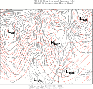
MODEL DIAGNOSTIC DISCUSSION
NWS HYDROMETEOROLOGICAL PREDICTION CENTER CAMP SPRINGS MD
143 PM EST FRI DEC 24 2010
VALID DEC 24/1200 UTC THRU DEC 28/0000 UTC
INITIALIZATION ERRORS IN NUMEROUS DIAGNOSTIC QUANTITIES...INCLUDING HEIGHT/VORTICITY FIELDS/RH...ARE EVIDENT IN BOTH THE 12Z NAM/GFS WITH SMALL BUT LIKELY SIGNIFICANT SHORTWAVE TROUGHS OVER SOUTH DAKOTA/NEBRASKA ALONG WITH SASKATCHEWAN/MANITOBA...WITH THESE AREAS ALSO NOT PARTICULARLY
RESOLVED OR PREDICTED WELL BY THE 00Z ECMWF.
THUS...THE SPECIFIC PREDICTIONS BY ALL DETERMINISTIC GUIDANCE ARE IN QUESTION...WITH THE RECOMMENDATION TO FOLLOW CONTINUITY...WITH THE FINAL OUTCOME MOST BELIEVED TO LIE BETWEEN THE 06Z GFS AND 00Z ECMWF...WITH ALL
ENSEMBLE GUIDANCE INCLUDING THE SREF MEAN/GEFS MEAN (EXCEPT NOT
THE 12Z VERSION)/ECMWF ENSEMBLE MEAN ALSO CONSIDERED USEFUL TO
ADDRESS THE CONTINUED UNCERTAINTY.
THIS APPROACH DISREGARDS THE SUBSTANTIALLY DEEPER AND WESTWARD SHIFT OF THE 12Z GFS REGARDING THE POWERFUL LOW TRACKING UP THE EASTERN SEABOARD...AND TO A LESSER EXTENT THE 12Z NAM WHICH LIES NEAR THE FAST EDGE OF THE GUIDANCE WITH THE DEVELOPING LOW.
Winter '10 / '11 - Snow Storm #1 - Call for Forecasts
![]() |
NYC 27-DEC-47 |
GooFuS hands the reins over to a strong 100kt digging short-wave in the northern stream SAT afternoon...a significant change from early projections where the main energy was contained in the southern stream. Coupled-jet streak configuration noted around mid-day SUN. Could be a notable event should the atmopsphere decide to read from this script.
Contest may be canceled prior to the deadline if NWP indicates a fizzling event.
-----
Deadline: 10:30 PM EST SAT...25-DEC-10
Forecast element: storm-total snowfall
Verification begins: 12:01 AM EST SUN...26-DEC-10
Verification ends: 11:59 PM EST MON...27-DEC-10
Enter your forecast at the Contest web site here.
Follow the link from 'Enter Storm Forecast.'
As always...there/s no cost...or fee...advertising...or annoying requests for personal information to enter. It's just a fun exercise among winter wx enthusiasts to see who can make the best synoptic-scale snowfall forecast.
If you are issuing your first forecast this year...or you entered the 'season-total' forecast contest...you/ll need to create an account (user name / password / valid e-mail...if you want a copy of your forecast sent to your Inbox).
If you want to be notified via e-mail when a 'Call for Forecasts' is issued...please let me know @ newx at newx-forecasts dot com.
Wednesday, December 22, 2010
Winter '10 / '11 - Stratospheric Warming - Another Try
Last signal failed to pan-out. Probability a long-shot given the poor odds for warmings with QBO in its positive / west phase....except when sunspot activity is high.
ECMWF hinting again at a break in the polar vortex (PV) last next week.
Note 1) the PV's pending split with separate circulation developing over the pole / central Russia and 2) the yellow area north-west of the Hudson Bay. The yellow indicates warmer temperature at 100 mb which implies a very cold troposphere. The slug of warm stratospheric air originated --- and is usually found -- over Siberia.
Winter '10 / '11 - Season-total Snowfall Forecast Contest - Forecast Summary
Individual forecasts on the Contest web site here.
Winter '10 / '11 - Coastal Teaser
Recent EC projections for a late weekend storm have been slower and stronger than GooFUS. Today's 12z GooFUS is now coming in line with the EC solutions such that the season's 1st contest-worthy storm may be in the offing come SUN.
A 'Call for Forecasts' is possible FRI...with an entry deadline of 10:30 PM EST...SAT 25-DEC-10.
Monday, December 06, 2010
Winter '10 / '11 - Signs of A Warming Stratosphere
Extended-range progs from the ECMWF continue to suggest a warming event may be in the offing come mid-DEC...foretelling a cold start to 2011 as the bottom of the Arctic Oscillation (AO) falls out.
Note the forecast of two distinct hi-latitude cyclonic circulation centers at 100 mb...which could be in the process of ingesting the hi-amplitude tropospheric ridges positioned currently over the north Atlantic and the Bering Sea.

Thursday, December 02, 2010
Winter '10 / '11 - Season-total Snowfall Forecast Contest - Call for Forecasts
Deadline: WED...15-DEC-10 @ 11:59 PM EST
Visit the Contest's website to enter your forecast.
Follow the link from 'Enter Season-total Forecast.'
---
As always...there are NO costs...fees...or annoying requests for personal information to enter.
NE.Wx's annual ‘Season-total' Snowfall Forecast Contest is the absolute best...biggest...and probably ONLY chance to be recognized for your long-range forecasting acumen; a recognition you so richly deserve.
Not only that...but if you actually win the Contest...you get a complementary copy of "New England Weather...New England Climate" by Gregory Zielinski and Barry Keim delivered right to your front door.
What other fookin'incentive could you possibly want to enter the Contest?
How about F-R-E-E shipping?
DONE!
________________________________________________
Forecast element: sum-total season snowfall @ each station
Forecast period: 01-DEC-10 through 31-MAR-11
Verification: NWS preliminary climate reports (CLM or F6)
Error statistic: total absolute error [Σ abs(forecast - observed)]
Entry deadline: WED...15-DEC-10 @ 11:59 PM EST
________________________________________________
The reigning NE.Wx ‘Season-Total’ Snowfall Forecasting Champ-een is Herb @ MAWS.
Last year's 'Season-total' forecast summary...verification...and final results ==> here.
________________________________________________
The Contest...as always...is open to any and all of the following:
Amateur and professional forecasters; broadcasters with or without trained Seals; weather-biz types and wanna-bees; wish-casters...astro-meteorologists...and other classes of dreamers; Pollyannas or Cassandras; registered Nostradamusians; non-violent megalomaniacs; woolly-bear caterpillars or their agents; pest detectives...NE.Wx Usenet NG or GoogleGroup regulars or lurkers...refugees from EUSWx...StormVista...Golden Snowball...AmericanWx...or USWxForums...including energy sectarians and meteorologists.
Trolls...goats...hat3-lsiters...and psests need not apply.
Wednesday, December 01, 2010
Winter '10 / '11 - NEWxSFC Status
![]() |
Long Island...NY 02-FEB-1934 |
'Call for Forecasts' announcements have also been made on the NEWxSFC web blog...web site...NE_WX GoogleGroup...StormVista...and at one time...The Golden Snowball. The 'Call for Forecasts'...'The Forecasts'...'Preliminary Verification'...and 'Final Results' posts on StormVista generated very few replies and a dozen or so views. Veteran NEWxSFC forecasters have made 'Call for Forecasts' announcements on other wx boards...such as EasternUSWx...with little effect. I appreciate their efforts and have been puzzled by how little interest was generated...given how much interest there is when winter wx threatens the M-A and NE.
Contest participation rates have remained steady over the years. Most events attract 8 - 15 forecasters. Most seasons see 8 - 10 forecasters eligible for ranking in the 'Final Standings.' Some veteran forecasters have understandably dropped out and few new forecasters stick around.
This winter would be Contest’s 12th season. NEWxSFC is the longest continuously held snowfall-forecasting contest on the World Wide Web. It has evolved over the years from a time when entries were harvested individually from ne.weather newsgroup and manually entered into a spreadsheet to an on-line interactive... password-protected Access database. NEWxSFC was cited in a paper delivered at the 90th Annual AMS Meeting [26th Conference on Interactive Information and Processing Systems (IIPS) for Meteorology, Oceanography, and Hydrology (http://ams.confex.com/ams/pdfpapers/164417.pdf)] JAN-10 in Atlanta…GA.
The ‘Regular’ season contest will kick off when the first contest-worthy storm presents itself.