Winter '10 / '11 - Snow Storm #1 - Storm Evolution at 500 MB
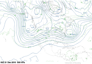
Short-wave trough comes ashore in southern CA on 23-DEC-10...undercuts the short-wave ridge axis over the Rockies on the 24th...then phases with a northern stream short-wave in over the lower MS River Valley. Note the strong cold air advection (CAA) driving the northern stream short-wave at 00z on the 26th prior to the phasing which causes the wavelength to shorten and amplify.
The mid-level circulation begins to close off 12 hours later at 12z on the 26th followed by a 12-hour 180 m height-fall between 00z and 12z on the 27th. Large height-falls at 500 MB indicate strong cooling aloft associated with strong upward vertical motion (UVM).
Stream-phasing was one element behind the flip-flopping of NWP solutions in the run-up to the snow storm.
Graphics courtesy University of Wyoming


