Friday, January 14, 2011

Winter '10 / '11 - North Atlantic Oscillation at Winter/s Crest

Meteorological winter has reached the half-way mark.  Coldest time of the year in the Northern Hemisphere...yet for much of the first half...temperatures have been much below normal...an unexpected oddity during la Nina.

This Hovmöller diagram from CPC shows the 5-day running mean of 5H anomalies above 65°N.

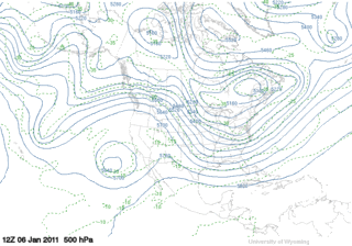
The strong action center along 60°W shows strength and persistence of the NAO over the past 90 days. 

The blocking HIGH over Greenland has weaken in recent days with a subsequent rise in the index to minus 2...heading for positive territory this weekend.

NAO is forecast to fall below zero later in the week as the PNA index rises to about 3...suggesting a favorable environment for coastal storms to develop off the SE coast.


Thursday, January 13, 2011

Winter '10 / '11 - Going Retro

Three-wave pattern forecast for 23-JAN-11 implies a retrogression of plantery low long waves.


This flow-regime evolution would claw the 5H anomaly westward to a position over Greenland...return the NAO to negative territory where it belongs...and reprise the currently cold temperatures over the eastern CONUS.

Winter '10 / '11 - Snow Storm #3 - Preliminary Verification

Preliminary storm-total snowfalls for Tuesday and Wednesday from CDUS41...CXUS51...and PNS...as of 8 AM Thursday.

No snowfall data in the NWS climate bulletins for SBY. Verifying storm-total snowfall of 0.05" was estimated from SBY/s METARs

---
Twelve new daily records.

WED...12-JAN-11

BDL - 24" (10.3"; 1996)
ORH - 21.1" (10"; 1996)
CON - 18.3" (8.6"; 1901)
BDR - 15" (3"; 2004)
BOS - 14.6" (6.7"; 1976)
ISP - 14" (2.1"; 2004)
PWM - 13" (10.2"; 1905)
ALB - 12.8" (10.2"; 1891)
BGR - 10.4" (5.7"; 1954)
BTV - 9.3" (5.9"; 1976)
EWR - 6.4" (3.2"; 1994)
JFK - 4.2" (1.6"; 1970)

---
Please report errors and drop a link to the correct data in Comments.

Final results and storm summary Friday evening.

Winter '10 / '11 - Snow Storm #3 - Teleconnections


Arctic Oscillation continues its long run at well below zero as a minor warming event takes hold in the stratosphere...shown below by the hi-latitude...above normal geo-potential heights (GPH).


Also note the AO/s classic tri-pole configuration...in this case with strongly positive 5H anomalies over the Bering Sea and a secondary maxima over NE Canada.


Tuesday, January 11, 2011

Winter '10 / '11 - Snow Storm #3 - The Forecasts

12 entries

1 Rookie
3 Intern forecasters
2 Journeyman forecasters
6 Senior forecasters including Chief forecaster Iralibov

Another 'true' snow storm unlike some years where we try to forecast what is little more than a narrow stripe of snow under the northern edge of a mainly rain storm's comma cloud.

---
All forecasts have been posted to the Contest's home page.
Follow the link from Storm #3.

Entries are ranked in ascending order by 'storm-total' snowfall.
Please check you entry for accuracy.


Broad range of expected storm-total snowfall...
Min: 112" (TQ)
Max: 216" (emoran)
Avg: 176"
Median: 174"
STD: 31"


Heaviest snowfall axis expected to fall inside BOS - ORH - BDL- ISP - PVD - BOS.

Winter '10 / '11 - Snow Storm #2 - Final Results

Daily Wx Map
08-JAN-11
1st - Donald Rosenfeld
SUMSQ: 115.75
SUMSQ Z: -0.945
STP: 15.60 (10)
TAE: 37.60 (1)
AAE: 1.39 (1)

2nd - Donsutherland1
SUMSQ: 116.46
SUMSQ Z: -0.937
STP: 4.80 (2)
TAE: 39.70 (3)
AAE: 1.47 (3)

3rd - Mitchel Volk
SUMSQ: 121.70
SUMSQ Z: -0.874
STP: 14.10 (9)
TAE: 39.40 (2)
AAE: 1.46 (2)

HM - Emoran
SUMSQ: 129.88
SUMSQ Z: -0.775
STP: 7.80 (5)
TAE: 40.70 (4)
AAE: 1.51 (4)

SUMSQ: sum of square errors
STP: storm total precipitation error
TAE: total absolute error
AAE: average absolute error
(number): category ranking

Full forecast verification and summary at the Contest home page.

Monday, January 10, 2011

Winter '10 / '11 - Snow Storm #3 - Raw Forecasts

The raw forecasts have been posted to the NEWx GoogleGroup.

Winter '10 / '11 - Snow Storm #2 - Preliminary Verification

Preliminary storm-total snowfalls for Friday through Sunday from CDUS41...CXUS51...and PNS.

No snowfall data in the NWS climate bulletins for SBY. Verifying storm-total snowfall of 0.5" was estimated using a SN:H2O ratio of 12.5:1...the same as RIC.

---
One new daily record.

SAT...08-JAN-11
ACY - 7.7" (6.6"; 1988)

---
Please report errors and a link to the correct data in Comments.

Final results and storm summary TUE evening.