Winter '09 / '10 - C-C-C-O-L-D December - Part Deux
 Amplification of the long-wave patten over NOAM appearing more likely with every model run.
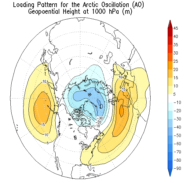
The long-advertised deepening of the Arctic Oscillation (AO) index to near record-levels...aided by on-going weak stratospheric warming event weakening the polar vortex... appears set to get under way the next day or two along with an off-the-chart...near record-setting rise in the Pacific-North American (PNA) index. Essential ingredients poised to fall in place for a stormy end of the month.
The return-period for an AO index less than or equal to -5.0 is 3.9 years for a total of 32 days since 1950 with no days observed that low since OCT-02. The record value of -7.433 was set 15-JAN-77.

The return-period for a PNA index greater than or equal to 2.5 is 5.6 years for a total of 24 days since 1950 and no days observed during winter. The record value of 3.397 was set 24-SEP-08.

Week 2 forecasts show broad positive (negative) 500 Z anomalies over the North Pole (across the western Atlantic) a perfect inverse match to the AO's loading pattern. Note the negative anomalies south of Alaska marking the position of the Aleutian LOW and an east coast CONUS storm track custom-made for Miller 'A' cyclogenesis.

Week2 positive sea-level pressure anomalies located at high latitude along the Prime Meridian and south-central Canada allowing arctic air to drain into low-latitudes creating a strong baroclinic zone along the Gulf of Mexico and SE CONUS coasts.
Daily teleconnection index values here.
Earth System Research Lab - Physical Sciences Division/s Week 2 Tercile Probability Forecasts here.
EDIT: corrected dates of record AO and PNA index values
EDIT: corrected dates of record AO and PNA index values


No comments:
Post a Comment