Sunday, February 28, 2010

Winter '09 / '10 - Snow Storm #7 - Final Results

NEWxSFC Chief forecaster donsutherland1 has won this season/s 7th snowfall forecast contest.

SUMSQ error: 132.3"
Z-score: -1.129

Improvement over the average error: 78% (595")

Lowest station errors @BTV and ABE

His forecast placed 1st in all categiories - storm-total precipitation...total absolute error...average absolute error...and R-SQ

Congratulations donsutherland1!

2nd Place: weatherT (299.1"; -0.720)
3rd Place: TQ (342.6"; -0.616)
Honorable Mention: millersville_bauers (382.4"; -0.518)

Full forecast verification...storm summary...and final results at the Contest web site.

Saturday, February 27, 2010

Winter '09 / '10 - Snow Storm #7 - Preliminary Verification

Preliminary storm-total snowfalls for Thursday and Friday from CDUS41 and METARs.

No climate or spotter reports for SBY.  METARs suggest trace amount.
Nine new daily records.

THU...25-FEB-10
BGM - 13.9" (4.2"; 1966)
ABE - 9.8" (3.2"; 1966)
ACY - 4.6" (1.6"; 1974)
EWR - 6.7" (2.4"; 2005)

FRI....26-FEB-10
BDR - 4.9" (3"; 2007)
ISP - 8.9" (2.9"; 1991)
JFK - 8.5" (6.4"; 1991)
ACY - 4.1" (2.8"; 1993)
EWR - 8.2" (4"; 1991)

Please report errors and a link to the correct data in Comments.

Final results and storm summary Sunday evening.

Friday, February 26, 2010

Winter '09 / '10 - Snow Storm #7 - The Forecasts

Forecaster Summary
Forecasts in the table below are ranked by storm total precipitation (STP) in ascending order. Blue (red) STP values are below (above) the 25th (75th) percentile of all forecast STPs.


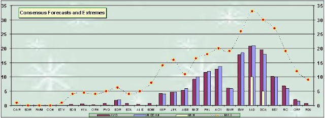
Average STP (126.5") per average number of stations (24) forecast: 5.3".

Twelve entries...including three Rookies...one Intern...and eight senior forecasters...issued 288 station forecasts for the winter/s 7th contest snow storm.

Everyone's station forecasts have been posted on the Contest's web site.


Consensus for a heavy-snow event over SE NY and eastern PA.


Arctic Oscillation (AO) remains stuck well below zero. North Atlantic Oscillation (NAO) has climbed to near-zero. Pacific-North American (PNA) has collapsed indicating a flattening flow across NOAM.


Rapidly deepening surface LOW off the HSE heading for NY Harbor. Storm b/comes trapped below strong HIGH pressure parked over Canada/s maritime provinces.

Verification period ends 11:59 PM EST...FRI 26-FEB-10.
Preliminary storm-total snowfall amounts will be posted the evening of SAT 27-FEB-10.

Wednesday, February 24, 2010

Winter '09 / '10 - Snow Storm #7 - Raw Forecasts

Raw forecasts here.
All forecasts will be posted to the Contest/s home page and a summary on the web blog Thursday evening.

Tuesday, February 23, 2010

Winter '09 / '10 - Snow Storm #7 - Call for Forecasts

Two-day event depicted on short and medium range models resulting from cyclogenesis off the VA / NC coast and the surface LOW/s retrograding motion over NJ and eastern PA blocked from lifting-out by HIGH pressure parked over Canada's Maritime Provinces.

-----
Deadline: 10:30 PM EST WED...24-FEB-10

Forecast element: storm-total snowfall
Verification begins: 12:01 AM EST THU...25-FEB-10
Verification ends:  11:59 PM EST...FRI 26-FEB 10

Enter your forecast at the Contest web site here.
Follow the link from 'Enter Storm Forecast.'

As always...there/s no cost...or fee...or annoying requests for personal information to enter. Just a fun exercise to see who can make the best synoptic-scale snowfall forecast.

If you are issuing your first forecast this year...or you entered the 'season-total' forecast contest...you/ll need to create an account (user name / password / valid e-mail...if you want a copy of your forecast sent to your Inbox).

Image:
Newark...NJ  27-DEC-47

Winter '09 / '10 - Interim Standings - 2

After six contest-worthy snow storms...the second interim standings have been posted here.

Under the 'Two-thirds' Rule...forecasters who/ve made at least four forecasts were included in the Interim Standings.

Image:  U.S. Capitol...8-Jan-39

Friday, February 19, 2010

Winter '09 / '10 - Snow Storm #6 - Final Results

NEWxSFC Senior forecaster ilibov has won this season/s 6th snowfall forecast contest.

SUMSQ error: 126.6"
Z-score: -0.746

Improvement over the average error: 53% (268")

Perfect forecast @ISP and SBY

Lowest station errors @CAR...PWM...ISP...ACY...and SBY

Congratulations ilibov!

2nd Place: herb @ maws (151.9"; -0.612)
3rd Place: donsutherland1 (153.5"; -0.604)
Honorable Mention: Donald Rosenfeld (189.5"; -0.413)

Full forecast verification...storm summary...and final results at the Contest web site.

Thursday, February 18, 2010

Winter '09 / '10 - Snow Storm #6 - Preliminary Verification

Preliminary storm-total snowfalls for Monday through Wednesday from CDUS41 and METARs.

No new daily records.

Please report errors and a link to the correct data in Comments.
Final results and storm summary Friday evening.

Monday, February 15, 2010

Winter '09 / '10 - Interim Standings

After five contest-worthy snow storms...the first interim standings have been posted here.

Under the 'Two-thirds' Rule...forecasters who/ve made at least four forecasts were included in the Interim Standings.

Ordinarily...the first interim standings would have been posted after three storms...but the storms just kept a'comin.'

Image:  Boston...1910.

Winter '09 / '10 - Snow Storm #6 - The Forecasts

Forecaster Summary
Forecasts in the table below are ranked by storm total precipitation (STP) in ascending order. Blue (red) STP values are below (above) the 25th (75th) percentile of all forecast STPs.

Average STP (93.8") per average number of stations (25) forecast: 3.8".


Nine entries...including two Rookies... one Intern...and six Senior forecasters...issued 229 station forecasts for the winter/s 6th contest snow storm.

Everyone's station forecasts have been posted on the Contest's web site.


Consensus for a modest SNE event.


Arctic Oscillation (AO) stuck well below zero. North Atlantic Oscillation (NAO) remains more than one standard deviation below its mean in response to hi-latitude omega block in the vicinity of Iceland. Pacific-North American (PNA) about one standard deviation indicating amplified westerlies across NOAM.


Disorganized area of surface LOW over OH Valley and the mid-Atlantic.  Storm b/comes better organized with height where closed circulations begin near 700 mb and continue throughout the remainder of troposphere.

Verification period ends 11:59 PM EST...WED 17-FEB-10.
Preliminary storm-total snowfall amounts will be posted the evening of THU 18-FEB-10.

Sunday, February 14, 2010

Winter '09 / '10 - Snow Storm #6 - Raw Forecasts

Raw forecasts here.

All forecasts will be posted to the Contest web site and a summary on the web blog Monday evening.

Saturday, February 13, 2010

Winter '09 / '10 - Snow Storm #6 - Call for Forecasts

Northern stream short-wave forecast to intensify as it swings onto the east coast from the Upper Plains. Surface LOW expected to follow a familiar path through BWI and along coastal SNE where NWP models suggest it may linger in the Gulf of Maine...blocked by strong HIGH pressure over Greenland.

-----
Deadline: 10:30 PM EST SUN...14-FEB-10

Forecast element: storm-total snowfall
Verification begins: 12:01 AM EST MON...15-FEB-10
Verification ends: 11:59 PM EST WED...17-FEB-10

Enter your forecast at the Contest web site here.
Follow the link from 'Enter Storm Forecast.'

As always...there/s no cost...or fee...or annoying requests for personal information to enter. Just a fun exercise to see who can make the best synoptic-scale snowfall forecast.

If you are issuing your first forecast this year...or you entered the 'season-total' forecast contest...you/ll need to create an account (user name / password / valid e-mail...if you want a copy of your forecast sent to your Inbox).

Friday, February 12, 2010

Winter '09 / '10 - Snow Storm #5 - Final Results

NEWxSFC Chief forecaster donsutherland1 has won this season/s 5th snowfall forecast contest.

SUMSQ error:232.5"
Z-score: -0.996

Improvement over the average error:  57% (542")

Perfect forecast @JFK

Lowest station errors @JFK and ORF.

Congratulations donsutherland1!

2nd Place: wxfox51* (260.5"; -0.905)
3rd Place: weatherT (302.4"; -0.771)
Honorable Mention: Raven (312.7"; -0.737)
*Rookie

Full forecast verification...storm summary...and final results at the Contest web site.

Thursday, February 11, 2010

Winter '09 / '10 - BWI/s Historic Snowfall Season

History in the making....with several more weeks of winter left on the clock.

Baltimore / Washington International airport (BWI) has measured 79.9" of snow as of 10-FEB...the most ever observed since record-keeping began in 1883.

How unusual is it for BWI to see this much snow in one winter?

This amount of snow would be considered a statistical outlier...more than four standard deviations (4.322) above the period-of-record mean of 21.9".

It's more snow than 99.994% of all other winters.

Other notable seasons at BWI were 2002/3 (58.1")...1995/6 (62.5")...1963/4 (51.8")... and 1898 (51.1")....all of which were more that two standard deviations above the mean (more snow than 95% of all other winters).
Interesting to note...three of the largest season-total snowfalls have occurred in the last 15 years...during a time when NHEMI areal snowfall has been generally well below average...especially during summer.
How rare is this winter/s snowfall?
How often can an extreme season such as this be expected?

Since it/s never happened during the period-of-record...a statistical technique using a Gumbel distribution can be applied to determine the 'return-period' for BWI receiving this amount of snow in one winter. The distribution and return-period are calculated using the 126-year historical season-total snowfall data from LWX.


The 126-year Gumbel distribution for BWI season-total snowfall is shown above.

The calculation...based on the line's slope...intercept...and a crisp double-inverse natural log function...shows the return-period as once every 675 years! The return-period for the runner-up 'Winter of 1995/96' is only 115 years.

Image: Baltimore...MD FEB-1899 (credit:  Baltimore Sun)

Winter '09 / '10 - Snow Storm #5 - Preliminary Verification

Preliminary storm-total snowfalls for Tuesday and Wednesday from CDUS41...METARs...and PNS bulletins.

No climate report for SBY at post-time. AKQPNS carried a report of 8" from law enforcement. The snowfall total seems reasonable when plotted along with other reports from the immediate area. This value may be revised if CDUS41 or CF6 bulletins are issued before final verification.

No spotter report for HYA in BOXPNS. The 11-FEB-10 METAR at 12z carried a 7/group report of 0.78". That was reduced by 0.01" to account for a brief period of rain which fell during the verification period. Storm-total snowfall was estimated at 6.8" by applying an 8.8:1 ratio...the observed ratio at PVD.

Eleven new daily records.
TUE...09-FEB-10
PHL - 6" (5.5"; 2006)
IAD - 11.5" (2"; 1980)

WED...10-FEB-10
BDR - 4.8" (1.9"; 1967)
BGM - 4" (2.3"; 2003)
ISP - 9.2" (T; 2008)
JFK - 11.1" (2.5"; 1967)
ABE - 17.3" (4.2"; 1926)
PHL - 9.3" (8.7"; 1926)
EWR - 13.2" (2.6"; 1964)
BWI - 15.5" (9.8"; 1926)
IAD - 9.3" (0.5"; 1986)

New daily snowfall records at ABE...PHL...and BWI were established on Wednesday. The old records were set in 1926.  Storm evolution was similar for both events with decaying parent LOW over OH and secondary development / Miller 'B' forming off the Carolina coast.

Here are the surface maps from FEB 9th and 10th...1926...courtesy NOAA's Daily Wx Maps archive.


Note the parent LOW over OH and the initial evidence of secondary / Miller 'B' development off the Carolina coast on the 09-FEB chart.


The 10-FEB chart shows the coastal LOW at 40°N with a minimum central pressure below 29.20" Hg (988.8 mb). Nantucket's 8 AM pressure was reported as 29.16" Hg (987.5 mb) with a 12-hour change of 0.58" Hg (19.6 mb) and a wind speed of 52 MPH (45 KTS).


Please report errors and a link to the correct data in Comments.
Final results and storm summary Friday evening.

Tuesday, February 9, 2010

Winter '09 / '10 - Snow Storm #5 - The Forecasts

Forecaster Summary
Forecasts in the table below are ranked by storm total precipitation (STP) in ascending order. Blue (red) STP values are below (above) the 25th (75th) percentile of all forecast STPs.

Average STP (181.5") per average number of stations (24) forecast: 7.6".


21 entries...including five Rookies... one who has entered their first contest this winter...three Interns...two Journeyman...and 11 Senior forecasters...issued 509 station forecasts for the winter/s 5th contest snow storm.

Two entries were disqualified; one b/c the forecast included one station only and one was submitted well past the deadline.

Everyone's station forecasts have been posted on the Contest's web site.


Consensus for a northern mid-Atlantic and coastal SNE event.


Arctic Oscillation (AO) remains well below zero.  North Atlantic Oscillation (NAO) has dipped to more than one standard deviation below its mean in response to hi-latitude blocking in the vicinity of Iceland.  Pacific-North American (PNA) above one standard deviation indicating amplified westerlies across NOAM.


Parent LOW over OH put down light snowfall today.  Triple-point / secondary development over GA at 21z has moved to the coastal waters of South Carolina at post time.  Miller 'B' storm progged to come up the coast tonight and tomorrow...side-swiping coastal sections of the mid-Atlantic and SNE.

Verification period ends 11:59 PM EST...WED 10-FEB-10.
Preliminary storm-total snowfall amountst will be posted the evening of THU 11-FEB-10.

Monday, February 8, 2010

Winter '09 / '10 - Snow Storm #5 - Raw Forecasts

Raw forecasts here.
 
All forecasts will be posted to the Contest web site and a summary on the web blog TUE evening.

Winter '09 / '10 - Snow Storm #4 - Final Results

NEWxSFC Rookie forecaster Roger Smith has won this season/s 4th snowfall forecast contest with a SUMSQ error of 392.2"...a 55% improvement over the average SUMSQ error of 876". His Z-score was a respectable -1.218.


Roger also placed 1st in the 'average absolute error' category with an average error of 2.7" per station (24 stations forecast).
He had the lowest station errors @BOS...MDT...BWI...and ORF.


Congratulations Roger Smith!

2nd Place: catatonia  (SUMSQ error: 493.2"; Z-score: -0.964)
3rd Place:  wxfox51*  (500.5"; -0.946)
Honorable Mention: herb @ maws (521"; -0.894)

*Rookie

Full forecast verification...storm summary...and final results at the Contest web site.

Sunday, February 7, 2010

Winter '09 / '10 - Snow Storm #5 - Call for Forecasts

Mid-level systems over NV and north of WI SUN evening are progged to phase over the next 24 hours and deliver a moderate-to-heavy snow event for the mid-Atlantic TUE/WED.  Current forecasts suggest coastal areas of SNE may be side-swipped by this storm.

NEWxSFC often does land office business in FEB and this year is no exception.  Snow storm #5 will be the third Contest snow storm in less than 10 days.

-----
Deadline: 10:30 PM EST MON...08-FEB-10

Forecast element: storm-total snowfall
Verification begins: 12:01 AM EST TUE...09-FEB-10
Verification ends: 11:59 PM EST WED...10-FEB-10

Enter your forecast at the Contest web site here.
Follow the link from 'Enter Storm Forecast.'


As always...there/s no cost...or fee...or annoying requests for personal information to enter. Just a fun exercise to see who can make the best synoptic-scale snowfall forecast.

If you are issuing your first forecast this year...or you entered the 'season-total' forecast contest...you/ll need to create an account (user name / password / valid e-mail...if you want a copy of your forecast sent to your Inbox).

Winter '09 / '10 - Snow Storm #4 - Preliminary Verification


Preliminary storm-total snowfalls for Friday and Saturday from CDUS41...METARs...and CF6 bulletins.

No climate report for SBY at post-time. AKQPNS carried a report of 14" from the airport's emergency manager.  This value may be revised if CDUS41 or CF6 bulletins are issued before final verification.

Interesting to note ACY/s SN:H2O below 10:1.  No rain observed at the station.  Almost 20" of wet...frozen concrete.

Some controversy concerning amounts @BWI.
From The Baltimore Sun...
"The contractor measured every hour on the hour and added it up. That produced a total of 28.6 inches.

He also took a "snow depth" reading, meaning that he measured all the snow at once, after it stopped falling.

Because of compaction, that came to 24.7 inches." 
BWI/s STP may be revised if new information b/comes available.

Nine new daily records.

FRI...05-FEB-10
ACY - 3.6" (1"; 1948)
BWI - 9" (6.4"; 1899)
IAD - 14.9" (1"; 2001)
DCA - 8.7" (7.5"; 1892)

SAT...06-FEB-10
PHL - 22" (12.4"; 1978)
ACY - 14.6" (11.5"; 1978)
BWI - 17" (8.4"; 1978)
IAD - 17.5" (4.4"; 1983)
DCA - 9.1" (4.4"; 1983)

Please report errors and a link to the correct data in Comments.
Final results and storm summary Monday evening.

Friday, February 5, 2010

Winter '09 / '10 - Snow Storm #4 - The Forecasts

Forecaster Summary
Forecasts in the table below are ranked by storm total precipitation (STP) in ascending order. Blue (red) STP values are in the 25th (75th) percentile of all forecast STPs.

Average STP (138") per average number (17) of stations forecast:  8.1".


28 entries...including 10 Rookies... seven of which entered their first contest this winter...three Interns...one Journeyman...and 12 Senior forecasters...issued 446 station forecasts for the winter/s 4th contest snow storm.

Two entries were disqualified b/c forecasts included one station only.
Everyone's station forecasts have been posted on the Contest's web site.


Consensus for a mid-Atlantic event.


Arctic Oscillation (AO) remains well below zero...heading once again for historical extrema.  North Atlantic Oscillation (NAO) and Pacific-North American (PNA) indexes essentially flat-line neutral.

Anemic NAO ahead of a potentially historic mid-Atlantic snowfall puts another nail in the coffin of CW about its supposedly critical importance for east coast snow.


Miller 'A/B' surface LOW...currently over GA...expected to kick-out quickly to sea late SAT afternoon...leaving the east coast via HSE.

Verification period ends 11:59 PM EST...SAT 06-FEB-10.
Preliminary storm-total snowfall totals will be posted the evening of SUN 07-FEB-10.

Thursday, February 4, 2010

Winter '09 / '10 - Snow Storm #4 - Raw Forecasts

Raw forecasts here.
 
All forecasts will be posted to Contest web site and summary information on the web log by FRI evening.

Wednesday, February 3, 2010

Winter '09 / '10 - Snow Storm #4 - Call for Forecasts

Phasing streams...negative tilted 5H trof...incredible amounts of Gulf o'Mexico moisture invading the mid-Atlantic...significant comma head / deformation.  HPC seems to think a major winter event is in the offing this weekend...so it's high time for Contest #4.

Odd 'Miller A/B'- looking cyclone this go'round... altho secondary coastal development isn't in response to northern stream energy but a second....southern stream short-wave flying east after under-cutting the high-amplitude long-wave ridge along west coast.
-----
Deadline: 10:30 PM EST THU...04-FEB-10

Forecast element: storm-total snowfall
Verification begins: 12:01 AM EST FRI...05-FEB-10
Verification ends: 11:59 PM EST SAT...06-FEB-10

Enter your forecast at the Contest web site here.
Follow the link from 'Enter Storm Forecast.'

As always...there/s no cost...or fee...or annoying requests for personal information to enter. Just a fun exercise to see who can make the best synoptic-scale snowfall forecast.

If you are issuing your first forecast this year...or you entered the 'season-total' forecast contest...you/ll need to create an account (user name / password / valid e-mail...if you want a copy of your forecast sent to your Inbox).

Monday, February 1, 2010

Winter '09 / '10 - Snow Storm #3 - Final Results

NEWxSFC Senior forecaster ilibov has won this season/s third snowfall forecast contest with a SUMSQ error of 85.3"...a 52% improvement over the average SUMSQ error of 176". Ilibov/s Z-score was a very strong -1.711.

Ilibov also placed 1st in every other categoory. 'Total absolute error' 25.9" (Z-score: -1.850)...'average absolute error' of 1.08" per station (24 stations forecast)....'storm total precipitation' error 3.1"...and an R-SQ of 67.7%.

Ilibov had the lowest station errors @BWI and DCA.

Congratulations Ilibov!

2nd Place: Shillelagh (SUMSQ error: 137.4"; Z-score: -0.727)
3rd Place: millersville_bauers* (140.6"; -0.668)
Honorable Mention: nnjwxguy78 (150.3; -0.483)

*Rookie

Full forecast verification...storm summary...and final results at the Contest web site here.

Winter '09 / '10 - Stratospheric Warming Event - II


Warming underway at 10mb...portends a cold end of month as hi-latitude blocking returns.

Imagery courtesy Climate Prediction Center.