Winter '09 / '10 - Snow Storm #4 - The Forecasts
Forecaster Summary
Forecasts in the table below are ranked by storm total precipitation (STP) in ascending order. Blue (red) STP values are in the 25th (75th) percentile of all forecast STPs.
Average STP (138") per average number (17) of stations forecast: 8.1".

28 entries...including 10 Rookies... seven of which entered their first contest this winter...three Interns...one Journeyman...and 12 Senior forecasters...issued 446 station forecasts for the winter/s 4th contest snow storm.
Two entries were disqualified b/c forecasts included one station only.
Everyone's station forecasts have been posted on the Contest's web site.
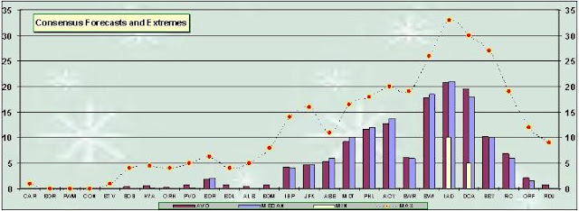
Consensus for a mid-Atlantic event.

Arctic Oscillation (AO) remains well below zero...heading once again for historical extrema. North Atlantic Oscillation (NAO) and Pacific-North American (PNA) indexes essentially flat-line neutral.
Anemic NAO ahead of a potentially historic mid-Atlantic snowfall puts another nail in the coffin of CW about its supposedly critical importance for east coast snow.

Miller 'A/B' surface LOW...currently over GA...expected to kick-out quickly to sea late SAT afternoon...leaving the east coast via HSE.
Verification period ends 11:59 PM EST...SAT 06-FEB-10.
Preliminary storm-total snowfall totals will be posted the evening of SUN 07-FEB-10.
Two entries were disqualified b/c forecasts included one station only.
Everyone's station forecasts have been posted on the Contest's web site.


Arctic Oscillation (AO) remains well below zero...heading once again for historical extrema. North Atlantic Oscillation (NAO) and Pacific-North American (PNA) indexes essentially flat-line neutral.
Anemic NAO ahead of a potentially historic mid-Atlantic snowfall puts another nail in the coffin of CW about its supposedly critical importance for east coast snow.

Miller 'A/B' surface LOW...currently over GA...expected to kick-out quickly to sea late SAT afternoon...leaving the east coast via HSE.
Verification period ends 11:59 PM EST...SAT 06-FEB-10.
Preliminary storm-total snowfall totals will be posted the evening of SUN 07-FEB-10.


No comments:
Post a Comment