Winter '11 / '12 - Outlooks
From CPC (0.5 month lead)...


La Nina continuing to hold sway over the forecast area for the last month of meteorological winter.
More winter Outlooks after the jump.
---
From the Bill Fortier writing for the Worcester TELEGRAM & GAZETTE...
"The consensus among forecasters is that this winter won’t be as severe ..."Fortier quoting weather historian and long-range weather forecaster Joseph S. D’Aleo...
“This weather pattern doesn’t show any signs of breaking down[...]. Alaska has been experiencing its coldest November since 1994 and weather history has shown that when it gets cold there, it is usually mild in the Northeast [...]."Fortier quoting CPC's deputy director Michael S. Halpert...
"The forecast for New England is for a winter in which the temperature and snowfall will be about average [...]. The reason for that forecast is that we don’t have any strong indicators of what we can expect [...]. There are no strong signals indicating it will be very cold or mild.”Fortier quoting Paul P. Pastelok...expert senior forecaster for AccuWeather.Com
"Accuweather.com is predicting a winter similar to NOAA’s forecast. We never said it was going to be a very cold winter in most of New England [...]."More here.
---
From Bloomberg...
"Winter’s bite probably won’t be as harsh in the U.S. Northeast and mid-Atlantic states as last year, according to Matt Rogers, president of Commodity Weather Group LLC.More here.
"Rogers updated his outlook in part because there’s no sign of pressure changes that would help trap cold air along the eastern U.S. In addition, November has been warmer than expected and December may follow suit.
"Rogers now forecasts that the Northeast, mid-Atlantic and Ohio Valley regions will have more seasonal temperatures in December rather than being 2 to 3 degrees Fahrenheit below normal, as predicted in October.
"The current stratospheric cooling argues for a more positive Arctic Oscillation and at least a big delay in a colder winter outcome.”
---

WSI Expects a Return to More Moderate Winter Temperatures
Slightly Colder-Than-Normal Conditions Anticipated Across Northern...US
Chief Meteorologist Dr. Todd Crawford said...
"...we...foresee a trend towards colder temperatures across much of the northern US, including the...Northeast, in December.”
"The winter pattern will be dominated by the current La Nina event, which favors below-normal temperatures across the northern US. [...] The temperatures across the eastern US will be further modulated by the North Atlantic Oscillation (NAO). [...] It does not appear that (an) extreme negative NAO phase will occur again this winter, which we think will result in a milder winter across all of the eastern US.
"For the Northeast...
December – Colder than normal
January – Colder than normal
February – Colder than normal"
More from WSI here.
---
"Following closely on HDD (ed: heating degree days) measures of the two previous winters, the 2011-2012 season will have similar stretches of bitterly cold weather. Both the West and Dixie regions look to get occasional breaks from the cAk regime.
"It is the Midwest that will have the most issues with unrelenting presence of frigid air. January looks to be the key month for HDDs."

"Dominated by strong 500MB ridges in the -EPO, -AO, and -NAO positions, intrusions of bitterly cold (cAk) values look to be common during the upcoming winter. In terms of temperature, the Great Plains and Midwest will suffer the most, while Texas and the Dixie states may get some breaks from the harsh domain in December and February.
"The strongest storms will be those which occur just ahead of the frigid regimes, in the "Colorado/Trinidad" and "Panhandle Hooker" trajectories. Alberta Clipper systems may appear with some frequency as well (accounting for a major lake effect snowfall pattern in November, December and early January.
"In the first month of 2012, the rather expanse of the Alaskan and Siberian outbreaks may suppress the mean storm track into the "Gulf Coaster" and "Hatteras Low" positions."

"Teleconnections on a dominant Hudson Bay cAk vortex with formative roots in northwestern Canada, however, favor the Great Lakes (lake effect related snow squalls) for important snow with the northern tier states from BC/WA/OR into Great Plains being very dry.
"The reason why is basic climatology for a La Nina episode, since past years may have followed the -ENSO trend. I strongly agree with the heavy precipitation threat for all of Appalachia (northern New England to AL/GA, as well as very dry conditions in KS, OK, TX. The heaviest of snows will be associated with Colorado/Trinidad "B" and Hatteras Low related systems."

"The coming winter season should compare favorably with the past two cold seasons, and in fact could exceed those bitter months."
---
WSI...
"...expects the upcoming period (November-January) to average cooler than normal in all of the northern and eastern US.
"While most of the major climate signals, including ocean temperatures in the major Northern Hemispheric basins and in the tropical Pacific, are again suggesting a cold winter, there are numerous indications that the cold will not be as extreme as it was during the last two winters,” said WSI Chief Meteorologist, Dr. Todd Crawford. “The current state of the oceans are almost identical to that observed in October 2008, which was only a moderately cold winter.
"Further, we have finally emerged from the unusually long lull in solar activity that likely contributed to the extreme nature of recent winters. Lastly, the multi-year tendency towards (sic) North Atlantic atmospheric blocking has already waned a bit in 2011, relative to the previous three years. This indicates that the atmosphere is likely regressing back (sic) to the mean a bit from the recent and persistent anomalous state.
"So, while we do expect another cold winter across much of the northern US, we think that the winter will be much closer to 2008-09 than 2010-11. Further, we think that the worst of the cold across the northern and eastern US will be in December and January, and that the back-half of winter could be significantly milder."

---
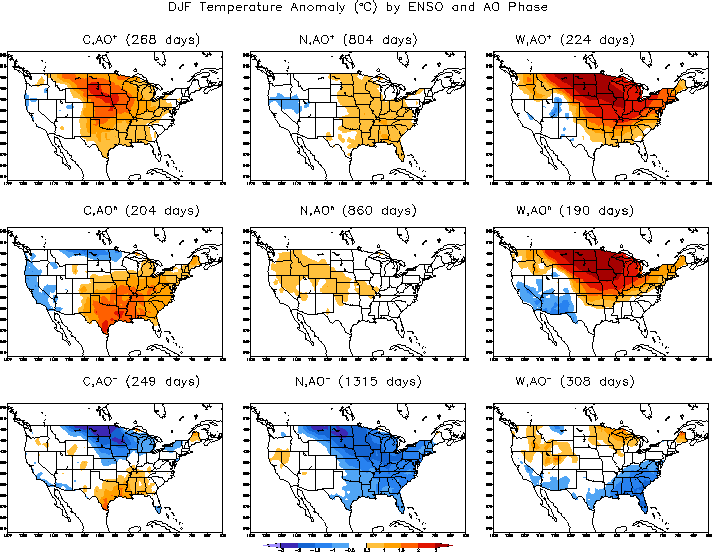
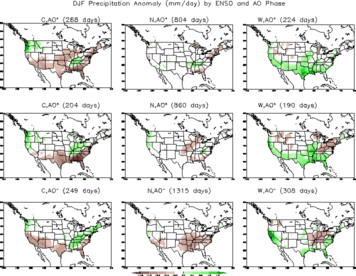
Essentially the same plain vanilla 'la Nina' winter forecast as their September outlook where anomalies are modulated by a neutral-to-negative Arctic Oscillation (AO) wrt temperature and a neutral AO wrt precipitation.


---

"Overall, this winter is not expected to be as extreme as last winter for the Northeast's major cities. However, there could still be a few snow or ice storms that have a significant impact.
"Snowfall is forecast to average near or even slightly above normal in areas south and east of the mountains from Virginia to Maine.
"Most of that snow is predicted to fall from December into January, making for an active start to the season for New York City and other big cities along the Interstate 95 corridor."
---
MDA DynaCast...

---
Teh Weather Channel...
"Below-normal temperatures will become more widespread in the eastern US in November and northern US in December as another round of early-season Atlantic blocking is expected.
- WSI expects that the new La Nina event will strengthen to moderate levels this winter
- WSI expects the temperatures for the upcoming late fall and winter seasons to lie between the 2008-09 and 2010-11 seasons, but closer to 2008-09
- WSI expects the coldest weather during the first half of winter again this season, with the focus of the winter cold over the north-central/northeastern US
---
DATELINE - Andover, MA (PRWEB)
September 20, 2011
WSI...
“The primary ocean signals suggest the late fall and early winter period will resemble those of the last three years, with an early start to winter in the eastern US.
"While October should be relatively mild across much of the US, below-normal temperatures will become more common in the eastern US in November and across all of the northern US by December,” said WSI Chief Meteorologist Dr. Todd Crawford.
“The combination of the newly-emerging La Nina event and the continued trend towards (sic) North Atlantic atmospheric blocking support both support this hypothesis.”
---


---
ECMWF...


---
“We’re looking at a cold start to the winter with maybe a mild finish,” said Matt Rogers, president of Commodity Weather Group LLC in Bethesda, Maryland. (H)e’s confident the start of winter will be colder because when there are back-to-back La Ninas, as in 2010 and 2011, the second one tends to bring lower temperatures to the U.S.
"The coming winter may be colder than both the 30- and 10- year averages...said Travis Hartman, a meteorologist at MDA EarthSat Weather in Gaithersburg, Maryland. He doesn’t expect a repeat of the past two years, when snow records fell in Central Park and some city streets were unplowed for days.
"The coldest area may be the northern Great Plains, Midwest and Great Lakes region, said Paul Pastelok, a meteorologist at AccuWeather Inc. in State College, Pennsylvania. The Northeast probably won’t be as cold or snowy as last year, he said.
"The U.S. Climate Prediction Center’s latest forecast for January to March 2012 calls for most of the U.S. to have seasonal temperatures, with about a 50 percent chance the upper Plains and Great Lakes will be below normal."
Bloomberg News: Looming U.S. Winter May Repeat Cold, Snow
---


---
TQ...
QBO: flipped in AUG from positive (west) to negative (east)
PDO: continuation of 'negative' mode
ENSO: developing la Nina
This trinity of indexes suggests a 'cold' winter outlook (somewhere).
---


---

---
DATELINE - Andover , MA (PRWEB)
August 23, 2011
According to WSI/ s Chief Meteorologist Dr. Todd Crawford...More: Below-Normal Temperatures in Eastern US by NOV / DEC
“The fall pattern will generally be driven by the very strong northern Pacific Ocean signal...
(N)egative...Pacific Decadal Oscillation...changes the downstream...pattern to favor very warm temperatures across...north-central and northeastern US for much of the fall season.
"As we near the end of fall, however...there are increasing chances for below-normal temperatures across the central and eastern US, as...blocking re-emerges.”


No comments:
Post a Comment