Winter '20 / '21 - 'Season-total' Snowfall Forecast Contest: DEC Totals
DEC-20 snowfall summary by forecast station.
Rank ordered descending by percent of monthly period-of-record-normal (P-O-R-N).
---
Green ==> 75th - 100th percentile
White ==> less than 75th and greater than 25th percentile (inter-quartile range)
Red ==> 0 - 25th percentile
---
DEC Forecast Station Highlights
15 stations above normal monthly snowfall
5 stations at least 200% of monthly normal
BGM
30" above normal
68% of its normal season-total snowfall
CON
53% of its normal season-total snowfall
ALB
47% of its normal season-total snowfall
Biggest Losers
RDU ... DCA ... ACY ... and ORF observed less than 10% of normal monthly snowfall
---
Season-Total-to-Date
DEC P-O-R-N contributes 203.3" (22%) toward the season-total snowfall (D-J-F-M) of 929".
DEC-20 observed snowfall: 292" (44% above P-O-R-N; 31% of season-total snowfall)
Image courtesy NOHRSC @ http://www.nohrsc.noaa.gov/nsa/
---
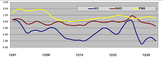
Teleconnections


2 comments:
What are thoughts on January 23-27 for good snow chances?
i think the period between 23-27 is two weeks away. nwp doesn't have much skill so far out. at least we're not staring down the barrel of a fatty ridge sitting over the SE.
overall ... a ridge-w / trof-e long wave pattern almost always holds promise for snowstorms as long as the wavelength shortens which keeps the storm(s) closer to the coast.
Post a Comment