Showing posts with label Upper Air. Show all posts

Wednesday, October 26, 2022

Winter '22 / '23 - An over-the-horizon look at early autumn's a priori climate conditions

near Woodstock ... VT
Marion Post Wolcott (1940)
TL; DR
- The stars have yet to align for snow crows and other winter wx enthusiasts.
- Above-normal temperatures and below-normal snowfall for most NEWxSFC/s stations.
 
> Warranties neither expressed nor implied.
> User assumes all risk.
> Not intended for use by children.
 
---
Decoder Ring
AO: Arctic Oscillation
CONUS: Continental United States
D-J-F: December-January-February
ENSO: El Niño - Southern Oscillation
EPO: Eastern Pacific Oscillation
M-A: Mid-Atlantic
NE: New England
NAO: North Atlantic Oscillation
NHEMI: Northern Hemisphere
NWP: Numerical Weather Prediction
PDO: Pacific Decadal Oscillation
QBO: Quasi-Biennial Oscillation
PNA: Pacific-North American pattern
SSTa: Sea-Surface Temperature anomaly
SSW: Sudden Stratospheric Warming
 
---
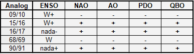
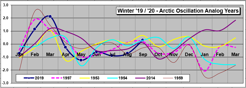
To the extent ENSO ... QBO ... SSTa in the tropical Pacific and the NE coastal waters of CONUS ... sunspots ... PDO ... and the extent of Eurasian cover have any predictive value ... here laid upon the table is the current state of play heading into Winter '22 / '23 as divined from NEWxSFC/s Whirled Headquarters located east of the fall line in VA.

Saturday, June 25, 2022

Winter '22 / '23 - Snowmageddon Weather in North America More Influenced by Tropics Than Arctic

"Winter weather patterns in North America are dictated by changes to the polar vortex winds high in the atmosphere, but the most significant cold snaps are more likely influenced by the tropics ..."

"The study, published in Geophysical Research Letters on December 27, 2019, also revealed that, unlike in Europe, the most extreme cold snaps affecting the whole of North America are not most likely to occur after a weak (polar) vortex. Instead, the shape of the vortex and conditions in the tropics were identified as stronger influences of these conditions"

More ...

Friday, November 05, 2021

Winter '21 / '22 - Quasi-Biennial Oscillation (QBO): OCT-21

-19.14 (just inside 1-sigma from the mean)

OCT is now the 5th month with a QBO index below zero having flipped in JUN following its 14 month run in positive territory.  The 30mb flow over the Equator oscillates from east to west every 14 months; therefore ... the current easterly state of the QBO is expected to last throughout Winter '21 / '22.

Leading analog years
Winter / ENSO (MEI)
72-73 / W+
00-01 / C-
09-10 / W
91-92 / W+
58-59 / W-

With La Nina temperature anomalies in ENSO Region 3.4 expected to persist through at least late winter ... all QBO analog years are rejected except Winter 00/01.

- Winter '00 / '01
The sum-total of the season-total snowfall for all Contest forecast stations was 1,312".  (~21% above the 1968 - 2021 period-of-record average 1,085".

Eurasia/s OCT areal snow cover slightly below normal.

D-J-F Index Averages
AO:  -1.312
NAO:  +0.040

"The QBO determines the character of the early winter, leading to a colder and more stable polar vortex in December and January during the west phase of the QBO and a more disturbed and warmer Arctic during the east phase of the QBO." [1]

In years with low solar activity (solar cycle 25 is just beginning) ... the polar winter vortex tends to be disturbed and weak when the QBO is easterly.  Positive geopotential height anomalies over high latitudes ... i.e., blocking ... are also correlated with QBO-E and solar minimums.
 
Antecedent odds currently favor a weak and disturbed stratospheric polar vortex and SSW (sudden stratospheric warming) leading to a long-lasting negative Arctic Oscillation (AO) and well-below normal temperatures periodically in eastern North America ... northern Europe ... or eastern Asia.


Thursday, December 10, 2020

Winter '20 / '21 - North Atlantic Oscillation (NAO): Analog Composites of 500 mb Height and 2-meter Temperature Anomalies ... as of NOV-20

 NOV:  +2.54 🔥🔥🔥
Only two other NOVs had a higher index ('78 +3.04; '93 +2.56)

TL;DR  This winter/s average NAO index expected to be positive ( >0 ).

---
Analogs and weights for composites:

'03 / '04 (1)
'99 / '00 (1)
'91 / '92 (1)
'93 / '94 (1)
'15 / '16 (1)

Each analog's average NAO for D-J-F was > 0.

NAO/s analog winters are assessed against the upcoming winter/s expected states of:
- ENSO (MEI moderate - trending weak La Nina)
- QBO-W < 10
- PDO (cool)

We removed '03 / '04 ... '91 / '92 ... and '15 / '16 from further consideration b/c they were +ENSO winters.  Winter '93 / '94 had QBO-E so it too drops out.

Winter '99 / '00 survives with its weak La Nina --- QBO-W < 10 ... and a cool PDO.

Sunday, October 04, 2020

Winter '20 / '21 - Severe Weather Europe: Winter Forecast

 Severe Weather Europe ...

"The La Nina phase will reach quite a formidable strength at its peak but is expected to start to weaken towards spring 2021."

"Historically, the most typical effect of a La Nina is a strong blocking high-pressure system in the North Pacific."

"North America winter forecast looks fairly solid to be a classical La Nina type winter. Most of western Canada is to expect colder and snowier conditions, along with Alaska.

"The United States expects to see a “dipole” pattern or a “two-faced” winter. The Northern [sic] United States are expected to be normal to colder and wetter. This increases the chance of more snowfall, but more likely towards the western half, and less likely in the eastern parts.

"The Southern [sic] United States can slowly prepare for warmer and mostly drier than normal winter weather. This however does not imply that [sic] no cold front can reach the southern states. It just implies that [sic] in a La Nina pattern, it is much less likely to get frequent cold fronts down to the very south."

Sunday, September 20, 2020

Winter '20 / '21 - How Arctic Amplification Affects the Polar Vortex

 "AER explains how accelerated Arctic warming, known as Arctic amplification, is increasingly disrupting the polar vortex, leading to widespread severe winter weather across the Northern Hemisphere’s mid-latitudes."

 https://youtu.be/EMeI4N5dui4

Tuesday, December 10, 2019

Winter '19 / '20 - Leading Analog: Winter '04 / '05

Through a careful multi-variate analysis of key teleconnection indices and the process of elimination ... we/ve settled on the '04 / '05 winter as this winter/s leading analog for the Contest/s forecast area.

Bottom line up front:
- Temperature:  near normal except below normal over far northern stations
- Snowfall:
Above normal - northern half of forecast area
Normal to below normal - southern half of forecast area

--- 
Consensus of dynamic and statistical model outlooks
ENSO:  La Nada+ (0.5°C < ENSO Region 3.4 SSTa < 0.5°C)

Current PDO state (OCT-to-MAR) < 0

2019 trend analysis
QBO:  W (+) going E (-)

2x2 contingency table (Chi-SQ Test for Independence) AO NAO
If NOV AO < 0 then 71% probability D-J-F average AO < 0
If NOV NAO > 0 then 73% probability D-J-F average NAO > 0

The analog winter/s key features follow:
ENSO:  +0.5°C (lowest threshold of weak El Niño)
MEI:  La Nada+
QBO:  W (+) going E (-)
PDO < 0
AO < 0
NAO > 0
EPO < 0
Contest stations' cumulative season-total snowfall:  1,446" (AVG:  1,095")

Winter '04 / '05 - 5H GPHa (l) & 2mTa (r)
Negative 5H GPHa - W & Negative 5H GPHa - E  ==> Trof-W / Trof-E
Neutral 2mTa over east coast; negative 2mTa over New England

---
Winter '04 / '05 monthly anomalies (D-J-F)
 
DEC '04 - 5H GPHa (l) & 2mTa (r)
Positive 5H GPHa - W & Negative 5H GPHa - E  ==> Ridge-W / Trof-E
Negative 5H GPHa INVOF Greenland ==> NAO > 0
Positive 5H GPHa INVOF Gulf of Alaska & Positive 5H GPHa eastern ATL ocean ==> AO > 0
Positive 5H GPHa INVOF Gulf of Alaska & negative 5H GPHa INVOF Hawaii ==> EPO < 0
Negative 2mTa over SE and Gulf Coast


JAN '05 - 5H GPHa (l) & 2mTa (r)
Negative 5H GPHa - W & Positive 5H GPHa - E  ==> Trof-W / Ridge-E
Negative 5H GPHa INVOF Greenland ==> NAO > 0
Positive 5H GPHa INVOF Gulf of Alaska & Positive 5H GPHa eastern ATL ocean ==> AO > 0
Positive 5H GPHa INVOF Gulf of Alaska & negative 5H GPHa INVOF Hawaii ==> EPO < 0
Positive 2mTa over SE and Gulf Coast; negative 2mTa over NE CONUS

FEB '05 - 5H GPHa (l) & 2mTa (r)
Negative 5H GPHa - W & Negative 5H GPHa - E  ==> Trof-W / Trof-E
Positive 5H GPHa INVOF Greenland ==> NAO < 0
Negative 5H GPHa INVOF Gulf of Alaska & Negative 5H GPHa eastern ATL ocean ==> AO < 0

Neutral 2mTa over east coast; positive 2mTa over NE CONUS

---
Key
5H - 500 mb
2mT - 2 meter temperature
2mTa - 2 meter temperature anomaly
GPHa - geopotential height anomaly
ENSO - El Nino Southern Oscillation
MEI - Multivariate ENSO Index
AO - Arctic oscillation
NAO - North Atlantic oscillation
EPO - Eastern Pacific oscillation
PDO - Pacific Decadal oscillation
CONUS - continental United States
INVOF - in the vicinity of

Tuesday, November 19, 2019

Winter '19 / '20 - Severe Weather Europe: FINAL November Model Forecast for the Upcoming Winter

"Most forecasts are showing certain lower pressure in the North Atlantic, and higher pressure over Europe and USA, which means generally  milder winter. The forecasts are on the same trend since September, which is very rare.

"Across the Atlantic, models generally agree on potential northerly flows over NW and NE USA and E Canada, while central USA currently has lower chances for winter weather overall.

"We still have the stratosphere as a major factor. Long-range forecasts are generally not as good at forecasting stratospheric dynamics in detail, which means they tend to underestimate any potential sudden stratospheric warming events (SSW’s) since the final forecast is made out of many individual calculations, which have different ideas about the stratospheric development.

"An SSW event can have a major impact on the circulation and can cause major pattern changes in the Northern Hemisphere. So a potential SSW event is an important factor that can change the course of winter in either way across the North Hemisphere."

Monday, November 18, 2019

Winter '19 / '20 - Pacific Decadal Oscillation (PDO): Leading Analogs' 500 mb Anomaly Height Composite ... as of OCT-19

Pacific Decadal Oscillation (PDO) composites of 500 mb (5H) geopotential height anomalies (GPHa) and 2-meter air temperature anomalies (2m Ta) for analog winters '66 / '67 ... '68 / '69 ... '90 / '91 ... '04 / '05 ... '17 / '18

5H GPHa composite
 - Trof-W / Ridge-E
- High GPHa INVOF Aleutian Is. & low GPHa INVOF Hawaii ==> EPO < 0
- Azores HIGH ==> NAO > 0
- High GPHa dipole Azores & Aleutian Is. ==> AO > 0

5H GPHa weighted-composite

2m Ta weighted-composite

Tuesday, November 12, 2019

Winter '19 / '20 - Quasi-Biennial Oscillation (QBO): Leading Analogs' 500 mb Anomaly Height Composite ... as of OCT-19

Quasi-Biennial Oscillation (QBO) composites of 500 mb (5H) geopotential height anomalies (GPHa) and 2-meter air temperature anomalies (2m Ta) for analog winters '78 / '79 ... '85 / '86 ... '95 / '96 ... '99 / '00 ... '02 / '03.

5H GPHa composite
- Ridge-W / Trof-E
- Hi-latitude blocking over Greenland ==> NAO < 0

5H GPHa weighted-composite

2m Ta weighted-composite

Saturday, November 09, 2019

Winter '19 / '20 - 500 mb Geopotential Heights and 2m T Anomaly Composites: La Nada Years


La Nada or neutral ENSO comes in two flavors -
Cool (-0.5 < Region 3.4 SSTa < 0)
Warm (0 < Region 3.4 SSTa < 0.5)

Current consensus expects 'warm' La Nada for Winter '19 / '20.

Recent La Nada years by decade:
1967
1979
1981 ... 1982 ... 1986 ... 1990
1991 ... 1993 ... 1994 ... 1997
2002 ... 2004
2013 ... 2014 ... 2017

5H GPHa composite - all La Nada years (n = 15)

Prevailing feature common to cool and warm La Nadas ...
- Positive 5H GPHa INVOF Aleutian Is. & negative 5H GPHa INVOF Hawaii = EPO < 0 ==> Arctic outbreaks into central CONUS

Thursday, November 07, 2019

Winter '19 / '20 - Eurasia Snow Cover: OCT

Eurasia/s areal snow cover for OCT-19: ~ 12,800,000 SQ-KM
24% above 52-year P-O-R-N (~10,300,000 SQ-KM)
27% above 52-year median (~10,100,000 SQ-KM)

Rank: 7th
3rd highest past 10 years
4 of past 20 years below median ('05 ... '07 ... '08 ... '11)
OCT-18:  ~10,400,000 SQ-KM
OCT-19: 23% greater than OCT-18


Ranked analog years 500 mb anomaly height composite for Winter '19 / '20
('15 / '16 ... '16 / '17 ... '09 / '10 ... '01 / '02 ... '14 / '15)

- High 500 mb geopotential heights at hi-latitude ==> NAO & AO < 0
- EPO > 0 ==> fast zonal flow over CONUS & mild PAC air masses
-weak evidence of trof over coastal M-A & NE CONUS


CORRECTION:  '15 / '16 & '09 / '10 ENSO should be 'W+'

Key
ENSO:  nada- (-0.5 < Region 3.4 SSTa <  0); C- (weak La Nina); W- (weak El Niño)
NAO:  sign of D-J-F average
AO:  sign of D-J-F average
PDO:  sign of O-N-D-J-F-M average
QBO:  + ==> west; - ==> east

Tuesday, November 05, 2019

Winter '19 / '20 - North Atlantic Oscillation (NAO): Leading Analogs' 500 mb Anomaly Height Composite ... as of OCT-19

Analog 5H composite ('80/'81 ... '08/'09 ... '12/'13 ... '14/15 ... '16/'17) ... as of OCT-19


- EPO-like ridge offset slightly to the west of preferred position for a 'Trof-East' regime
- Azores HIGH ==> NAO > 0
- Low geopotential heights over pole ==> AO > 0
- Negative height anomaly over southeast Canada favors primary storm track through the Upper Plains and across the Great Lakes in line with current soil moisture axis

Weighted analog 5H composite

Weighted analog 2m T composite

Sunday, October 20, 2019

Winter '19 / '20 - What Is the Polar Vortex and How Does It Influence Weather?

"The term polar vortex has become part of the everyday vocabulary after the widespread media coverage of the extreme cold events over the United States during the early winter of 2014.

"However, there is some confusion in the media, general public, and even within the science community regarding what polar vortices are and how they are related to various weather events."
[...]
"... since surface weather disturbances are associated only with displacements of the vortex edge in limited areas rather than hemispheric-scale changes to the vortex, it is not clear ... invoking the term vortex clarifies anything, given ... the vortex is a hemispheric-scale structure.

"Use of the term without adequate explanation can suggest a more dramatic change to the global tropospheric circulation than has actually occurred (e.g., “The polar vortex is back!”)."

---
Learn more about the PV from the full article courtesy the Bulletin of the American Meteorological Society (BAMS) here.

Friday, October 18, 2019

Winter '19 / '20 - Statistical Winter Outlook: Solar cycle and ENSO

Severe Weather Europe's (SWE) analysis of the solar cycle and ENSO analogs ...


"After removing all the cold phases and strong warm phases of ENSO, we get a very interesting and more defined picture. We see a high pressure area focused over Greenland and the Arctic, typical for negative NAO & AO.

"Lower pressure is displaced a bit further south, along with polar fronts and colder air. This type of pattern usually brings colder and snowy weather to Europe and USA."

SWE/s solar cycle / ENSO analysis in general agreement with our current QBO ... AO ... and Eurasia snow cover analogs.

Saturday, October 12, 2019

Winter '19 / '20 - Quasi-Biennial Oscillation (QBO): Leading Analogs' 500 mb Anomaly Height Composite ... as of SEP-19

Analog 5H composite ('78/'79 ... '85/'86 ...'95/'96 ... '99/'00 ... '02/'03) ... as of SEP-19

- Ridge-W Trof-E
- Hi-latitude blocking ==> AO & NAO < 0
- EPO < 0

---
Analog years for Winter '19 / '20

CORRECTION:  '78 / '79 & '85 / '86 ENSO should be 'W-' & 'C-' ... respectively.
 
KEY
ENSO:  nada- (-0.5 < SSTa <  0); C- (weak La Nina); C+ (strong La Nina); W (moderate El Niño)
NAO:  sign of D-J-F average
AO:  sign of D-J-F average
PDO:  sign of O-N-D-J-F-M average

Tuesday, October 08, 2019

Winter '19 / '20 - Eurasia Snow Cover: SEP

Eurasia/s areal snow cover for SEP-19: ~1,570,000 SQ-KM

3% below 48-year P-O-R-N (~1,629,000 SQ-KM)
1% below 48-year Median (~1,588,000 SQ-KM)

Rank: 26th
4th lowest past 10 years
11 of past 20 years below median
SEP-18:  ~1,300,000 SQ-KM
SEP-19 21% greater than SEP-18


KEY
ENSO:  nada+ (0 < SSTa <  0.5); C- (weak La Nina); W- (weak El Niño); W (moderate El Niño); W+ (strong El Niño)
NAO:  sign of D-J-F average
PDO:  sign of O-N-D-J-F-M average
QBO:  + ==> west; - ==> east

Saturday, October 05, 2019

Winter '19 / '20 - Arctic Oscillation (AO): Leading Analogs' 500 mb Anomaly Height Composite ... as of SEP-19

Analog 5H composite ('53/'54 ... '54/'55 ...'59/'60 ... '97/'98 ... '14/'15) ... as of SEP-19

- Overall North American pattern mimics Tropic/Northern Hemisphere's (TNH) negative phase often associated with +ENSO.

- Positive height anomaly over eastern Canada displaces climatologically favored position of Hudson Bay trof limiting high-latitude cold air supply to the Lower 48.

- TNH associated with stronger than normal Pacific jet farther south of its normal axis and well above normal temperatures in eastern North America.


CORRECTION:  '53 / '54 ENSO should be 'W-'

KEY
ENSO:  nada- (-0.5 < SSTa <  0); C- (weak La Nina); W- (weak El Niño); W (moderate El Niño); W+ (strong El Niño)
NAO:  sign of D-J-F average
PDO:  sign of O-N-D-J-F-M average
QBO:  + ==> west; - ==> east; +/- flipped west to east

Thursday, October 03, 2019

Winter '19 / '20 - North Atlantic Oscillation (NAO): Leading Analogs' 500 mb Anomaly Height Composite... as of AUG-19

UPDATE:  SEP/s NAO did not change the analog years other than to shuffle the 4th and 5th ranks.

---
Analog 5H composite ('50/'51 ... '08/'09 ... '12/'13 ... '16/17 ... '17/'18) ... as of AUG-19


- Another round of Trof West - Ridge East

- EPO-like ridge offset slightly to the west of preferred position for a 'Trof-East' regime

- Azores HIGH suggests NAO > 0

- Negative height anomaly over south-central Canada favors primary storm track through the Upper Plains and across the Great Lakes in line with current soil moisture axis.


Winter '19 / '20 NAO analog analysis here.

Saturday, January 26, 2019

Winter '18 / '19 - We're the Heckawi

Mid-Atlantic winter wx enthusiasts couldn't ask for better synoptics than the current long wave flow regime.

- High amplitude ridge to the West.
- Full latitude trof in the East.
- Sub-tropical jet in a split flow
- Split stratospheric polar vortex with the stronger daughter vortice over eastern North America to boot.

So WTF?
If times be so good ... then bro ... where's my fookin' snow?

Us snow crows nesting here in the eastern half of the mid-Atlantic will most often get our winter wx fix when ...
1) LOW pressure spawns over the Gulf of Mexico & proceeds to crawl slowly up the east coast and

2) A strong Arctic HIGH (1040-ish mb; 30.70" Hg) parks herself over Maine and

3) The wavelength between the Ridge-West / Trof-East pattern contracts i.e., becomes shorter.  As the wavelength shortens ... storms spin-up (intensify) the same way ice skaters spin-up when when they draw their arms inward (see  Conservation of Angular Momentum)

Wicked winter wx 'round here has always been a tricky combination of having a deep layer of Arctic / Polar air in place ... ready to interact with moisture surging from the south.

The current long wave flow regime is certainly delivering in spades with the cold air component; however ... it's coming on too strong ... in effect suppressing moisture from coming north.

FWIW ... the world-wide federation of numerical weather prediction (NWP) models have been tilting toward an adjustment to the long wave pattern in mid-range; a shuffling of the deck so to speak (more like re-setting the tumblers in a one-armed bandit).

Climatologically for snow crows ... FEB is our time 'round here ... especially the period either side of mid-month.  Whether the coming pattern change produces the weather we be waiting for is anyone's guess.

Even though long-range NWP offers us nothing more than possible outcomes ... outcomes more often fantasy than fact ... it's one of those j'ne sais WTF reasons why we all be Weather Weenies.

---