Thursday, November 12, 2009

Tuesday, November 10, 2009

Winter '09 / '10 - Pig Spleens as Predictors

“It is a bad winter... It’s going to turn real nasty.More ...
“In March it looks even worse than it does (in January)...”
"Mr. Schulz uses the width and height of pig spleens to determine if the up-coming winter will be mild and dry or cold and snowy.
"His outlook this year: buy a new shovel."
Monday, November 09, 2009
Winter '09 / '10 - Quasi-biennial Oscillation - October
-11.70.
A stronger negative value was expected b/c the cycle is five months into its easterly phase.
1991 continues to be the best YTD-analog...followed by 1986...1981...2000...and 1967. Note its close fit...including the slight upturn through NOV before resuming its decline into spring.

Strong +ENSO...as measured by MEI...was in excess of +1.5 and reached a max value of +2.248 during spring 1992. The analog year is the highest-ranked of those matching the top-5 QBO years.
PDO was weakly positive during the winter...dipping close to zero in JAN before turning strongly positive by mid-spring. It/s the fourth ranked analog.
1991 is the top analog for AO and 4th for NAO. AO was above zero NOV through MAR...and above +1 DEC and FEB. Similar tale for NAO...altho JAN/s dip to -0.13 did little to affect the winter/s +0.568 index average.
Sunspots for the period D-J-F-M totaled 576...not a good match for this year/s extreme minima values.
 The two tables show the top-5 analog years for QBO. The top table displays the rank of the corresponding years for other teleconnection indexes, i.e., the 1991 PDO is ranked fourth of all PDO analog years. The 'Total' column sums all 'rank' values for the analog year. Low score wins with this decision analysis scheme. North American snow cover (NA SN) is not included in the scoring b/c data are not available for all analog years.
 Richmond...VA - 0.9"
DC - 6.6"
Baltimore...MD - 4.1"
Philadelphia...PA - 4.7"
NYC - 12.6"
Binghamtom...NY - 56"
Boston...MA - 19.1"
Concord...NH - 33.6"

Previous QBO post here.
 The two tables show the top-5 analog years for QBO. The top table displays the rank of the corresponding years for other teleconnection indexes, i.e., the 1991 PDO is ranked fourth of all PDO analog years. The 'Total' column sums all 'rank' values for the analog year. Low score wins with this decision analysis scheme. North American snow cover (NA SN) is not included in the scoring b/c data are not available for all analog years.
The bottom table assigns a score relative to all rankings in the same column and assumes every column carries equal weight. Further refinement to this decision analysis table would assign relative weights to each teleconnection index. MEI might be weighted 35% and the contribution from sun spots set to 10%.
Note the 1991 PDO is ranked 1st among the other PDO years and has the top score of 1. The 1991 'Sun Spots' has a low score of 0.10 b/c more sun spots are not associated with colder winters. 1986 has the lowest sun spot count and is scored 1.
1991 QBO has the highest total score of 4.01. Its score is more than twice as high as the second best analog year 1986...50% higher than 2000...and a strong choice when paired with other teleconnection indexes.
The winter of 1991 produced much below normal snowfall in the mid-Atlantic and southern New England...as is typical for QBO-east and +ENSO winters.
 Richmond...VA - 0.9"
Baltimore...MD - 4.1"
Philadelphia...PA - 4.7"
NYC - 12.6"
Binghamtom...NY - 56"
Boston...MA - 19.1"
Concord...NH - 33.6"

Previous QBO post here.
Monday, November 02, 2009
Winter '09 / '10 - NHEMI Snowcover - October
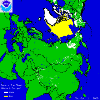
NHEMI snow cover is above normal...a somewhat common phenomenon this decade. Recovery was rapid...after falling ~2% below normal seven or so days into the month.
Snow cover anomaly is over land areas between 35°N and 55°N is currently +6%.
Good autumn snow cover over EURASIA plays an important role in defining winter's character. It perturbs the troposphere in such a way as to weaken the polar vortex (PV). Arctic air masses are better able to drain into lower latitudes when the PV is weak. The PV is also weaker when the QBO is east...as it will be this winter. More about EURASIAN snowcover/s predictive role in winter/s wx here.
Good autumn snow cover over EURASIA plays an important role in defining winter's character. It perturbs the troposphere in such a way as to weaken the polar vortex (PV). Arctic air masses are better able to drain into lower latitudes when the PV is weak. The PV is also weaker when the QBO is east...as it will be this winter. More about EURASIAN snowcover/s predictive role in winter/s wx here.


The combination of rich snow cover in EURASIA and QBO-east could provide the impetus for hi-latitude blocking and a persistently negative state of the northern annular oscillations known as the Arctic Oscillation and the North American Oscillation... which favors above-normal season-total snowfall in the NE and mid-Atlantic regions. +ENSO-related +PNA and an active lo-latitude / southern-tier storm track should provide ample opportunity for phasing and strong Miller-A cyclogenesis along the eastern seaboard.
More global snowcover charts @ FSU...NOAA...and Rutgers
Winter '09 / '10 - SOI - October
-14.7 and falling!
October registers a rather robust value compared to historical values for the month (data) and a sharp decline from September (+3.9). Last month's SOI is almost two standard deviations (2STD = -19.5) below the period of record normal.

The Southern Oscillation index (SOI) has been oscillating about 0 since early spring...in contrast to Multivariate ENSO Index (MEI) which has been bullish on +ENSO during the same period.
With the addition of October's SOI...the 'Top-5' analog years (using a least-squares and coefficient of determination method) are...
1 - 2001 (also top-ranked analog year for NHEMI snow cover and 4th for NOAM snow cover)
2 - 1984 (also 5th rank for NOAM snow cover)
3 - 1999 (also 3rd rank for NOAM snow cover and 5th rank for NAO)
4 - 1963
5 - 1967
SOI turned positive during the '01 / '02 winter. Not a good match given the widespread expectation for a moderate +ENSO event.
1984 would be a slightly better analog. QBO was east...as will be the case this winter; however...MEI indicated -ENSO conditions.
1999 was a moderate -ENSO winter.
1963 has a good association with MEI...which was moderate +ENSO. QBO was west and PDO negative.
1967 was not quite a moderate -ENSO winter.
Not a lot of corroborating support for choosing SOI as a leading indicator for the upcoming winter.
Friday, October 30, 2009
9th Annual 'Season-total' Snowfall Forecast Contest
 CALL FOR FORECASTS
Deadline: Monday...30 November...2009 @ 11:59 PM EST
Forecast the season-total snowfall for 25 stations from RDU to CAR.
Visit the Contest's website to enter your forecast. Follow the link from 'Enter Season-total Forecast.'
As always...there/re no costs...fees...or annoying requests for personal information to enter.
NE.Wx/s annual ‘Season-total' Snowfall Forecast Contest is your absolute best...biggest...and probably ONLY chance to be recognized for your long-range forecasting acumen; a recognition you so richly deserve.
Not only that...but if you win the Contest...you get a copy of "The Snow Booklet"...by Nolan J. Doesken and Arthur Judson or "New England Weather New England Climate"...by Gregory Zielinski and Barry Keim delivered right to your front door.
What other incentive could you possibly want to enter the Contest ?
How about F-R-E-E shipping? DONE!
________________________________________________
Forecast element: sum-total season snowfall @ each station
Forecast period: December 1, 2009 through March 31, 2010
Verification: NWS preliminary climate reports (CLM or F6)
Error statistic: total absolute error [Σ abs(forecast - observed)]
Deadline: Monday...30 November...2009 @ 11:59 PM EST
________________________________________________
The reigning NE.Wx ‘Season-Total’ Snowfall Forecasting Champ-een is TQ.
Last year/s forecast summary and final results here.
The Contest is open to any and all of the following:
Amateur and professional forecasters; broadcasters with or without trained Seals; weather-biz types and wanna-bees; wish-casters...astro-meteorologists...and other classes of dreamers; Pollyannas or Cassandras; registered Nostradamusians; non-violent megalomaniacs; woolly-bear caterpillars or their agents; pest detectives...NE.Wx Usenet NG or GoogleGroup regulars and lurkers...refugees from EUSWx...StormVista...Golden Snowball...energy sectarians...and meteorologists.
Trolls...goats...hat3-lsiters...and psests need not apply.
Thursday, October 22, 2009
Winter '09 / '10 - Too Much...Too Soon?

How much longer can the current flow regime support 'Nor-easters R-Us'?
Full-latitide mean trof axis INVOF 80°W
Bagginess @5H
Cyclogenesis off the SE coast
Crashing AO currently @-2.535 (-4.87 index delta past 30 days)
All good things must come to an end...to coin phrase. Forecasters must always face facts...flow regimes don/t last forever.
What are the realistic chances the current pattern continues deep into winter? Is this too much...too soon?
Monday, October 19, 2009
Winter '09 / '10 - WSI - October Update
Dr. Todd Crawford - seasonal forecaster:
PRWeb
"The WSI winter forecast for December through February shows below-normal temperatures across the eastern and southern United States, with above-normal temperatures across the northwestern half of the country.Reuters
""Recent changes in Pacific Ocean temperatures along with other factors, such as reduced solar flux, have combined to produce a favorable environment for a cold winter in the eastern U.S. this year...
""Confidence in the cold winter forecast will increase further if snow cover builds rapidly at higher latitudes during October. Our current forecast indicates a relatively benign start to winter, followed by a rather active and cold January and February."
"In December, WSI sees the monthly breakdown as:
Northeast - Warmer than normal
"In January, WSI forecasts:
Northeast - Colder than normal"
PRWeb
Sunday, October 18, 2009

Subscribe to:
Posts (Atom)


