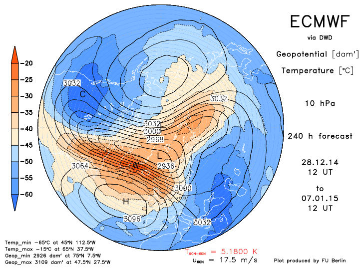
Output from the ECMWF 12z / 21-DEC-14 run shown below forecasts
1) significant weakening of the PV from 145 KT at initialization to 50 KT on the 240-hr prog and
2) beginnings of a PV reversal (mean easterly wind above 5 mb)
3) maintenance of a strong sub-tropical jet (STJ)
"Pronounced weakenings of the NH wintertime stratospheric polar vortex tend to be followed by episodes of anomalously low surface air temperatures and increased frequency of occurrence of extreme cold events throughout densely populated regions such as eastern North America, northern Europe, and eastern Asia that persist for ~2 months."
REF:
http://www.nwra.com/resumes/baldwin/pubs/Thompsonetal_2002.pdf
QBO/s SUPPORTING ROLE
Winters in a negative / easterly QBO regime favor PV weakening and subsequent SSW events. In years with low solar sunspot activity ... the polar winter vortex also tends to be disturbed and weak when the QBO is easterly; however ... solar sunspot activity is neither high nor low.
FWIW
Top three QBO analog years are 1972 ... 1958 ... and 2009.
1972/3 - strong el Nino
1958/9 - weak el Nino
2009/10 - moderate el Nino
QBO phases typically last ~13 months before reversal.
The QBO is seven months into its east phase through NOV-14 and will remain negative throughout this winter.
Winter '58 / '59 snowfall in the southern M-A was well above normal ... central M-A and NNE much below normal ... and SNE below normal.
OUTLOOK
The time to propagate a SSW-induced west-to-east flow reversal from 10 mb to the near-surface is variable but averages ~3 weeks. All else equal ... should the 12z 21-DEC-14 ECMWF perfect-prog verify ... the full effects associated with a persistently negative Arctic Oscillation (
AO) would not be felt at the surface until late JAN at the earliest.