Thursday, November 15, 2018
Wednesday, November 14, 2018
Winter '18 / '19 - Snow Storm #1: Call for Forecasts!
 |
| Brooklyn ... NY 26-NOV-38 |
Contest-worthy snow storms in NOV are quite rare with only two since NEWxSFC started in 1999 (2003 & 2013).
Earlier than usual deadline (8 PM EST) b/c of the expected pre-midnight on-set of accumulating snows.
Deadline: 8:00 PM EST … THU … 15-NOV-18
Verification begins: 8:00 PM EST … THU … 15-NOV-18
Verification ends: 11:59 PM EST … FRI … 16-NOV-18
Enter your forecast at the NEWxSFC/s home page @ http://www.newx-forecasts.com/
Follow the top center-of-page link from 'Enter Storm Forecast.
Sunday, November 11, 2018
Winter '18 / '19 - Eurasia Snow Cover: OCT

Last year: ~12,052,000 km2
1% above 53-year P-O-R-N (~10,260,000 km2)
Rank: 22nd
Lowest in eight years
Seven of the last ten years above normal
Analog years for winter '18 / '19
Rank Winter ENSO
1 82-83 W+
2 00-01 C-
3 69-70 W-
4 01-02 nada-
5 84-85 C
---
Data courtesy Rutgers University Global Snow Lab
http://climate.rutgers.edu/snowcover/index.php
Saturday, November 10, 2018
Winter '18 / '19 - Gains and Losses: 10-NOV-18
Minor snow event over extreme northern portions of the forecast area today forced by a lifting 5H LOW centered @12z over SE Canada and 2ndry SFC LOW occluding INVOF the Gulf of ME.
Gains: Blue
Losses: Reds

Winter '18 / '19 - Snow Advance Index and Season-total Snowfall in the NE and Mid-Atlantic
The Snow Advance Index (SAI) measures the mean daily rate-of-change in Eurasia's areal snow cover at latitudes equatorward of 60°N during OCT. Published research suggests rapid increases in Eurasia/s OCT areal snow cover are associated with increased season-total snowfall (STP) in the eastern U.S.
Does the SAI provide useful guidance for season-total snowfall at NEWxSFC forecast stations?
Meh ... me thinks.

This analysis looks at the relationship between the SAI and NEWxSFC stations' STP for the winters between '70 / '71 and '17' / '18 (n = 48).
PCT increase in areal coverage is proxy for the mean rate of change of snow cover extent (SCE) from daily snow cover data in the above referenced study. (Cohen and Jones 2011).
AVG PCT increase in weekly Eurasian areal snow cover between Week 40 and Week 44 (OCT): 416% (ORANGE LINE)
OCTs ... where SAI > AVG: 20
Accordingly ... if OCT/s SAI is above AVG ... then STP at NEWxSFC forecast station should also be > AVG.
---
AVG 'season-total' snowfall (STP) for NEWxSFC forecast stations: 1,042" (GREEN LINE)
Winters ... where STP > AVG: 23
---
The question the analysis wants to answer:
Does the SAI-proxy - PCT increase in Eurasia/s OCT snow cover - predict whether NEWxSFC forecast stations' STP > AVG.
---
Years ... where SAI > AVG & Years ... where NEWxSFC stations' STP > AVG: 11 (RED DOTS)
Recall ... there were 20 years when OCT/s SAI > AVG which means nine years the STP < AVG.
Probability of OCT SAI > AVG: 42% (20/48)
For any given OCT ... there's a 42% chance of SAI > AVG.
Probability NEWxSFC stations STP > AVG: 48% (23/48)
For any given year ... there's a 48% chance of STP > AVG.
What's the probability given SAI > AVG ... the STP will also be > AVG?
Cumulative probability for NEWxSFC stations STP > AVG ... given SAI > AVG: 42%
---
BOTTOM LINE: In any given year ... if the SAI > AVG ... there's a 42% chance the 'season-total' snowfall ... for all NEWxSFC forecast stations ... will be above the period of study's AVG 'season-total' snowfall.
Looking at it another way ... there's a 58% chance the 'season-total' snowfall ... for all NEWxSFC forecast stations ... will _not_ be above the period of study's AVG 'season-total' snowfall. This isn't to say SAI doesn't offer useful guidance for individual NEWxSFC forecast stations.
OCT-18/s PCT snow cover increase is just under 500% or ~80 PCT-points > AVG; therefore ... there/s a mere 42% chance this season the STP from NEWxSFC/s forecast stations will be > AVG.
Saturday, November 03, 2018
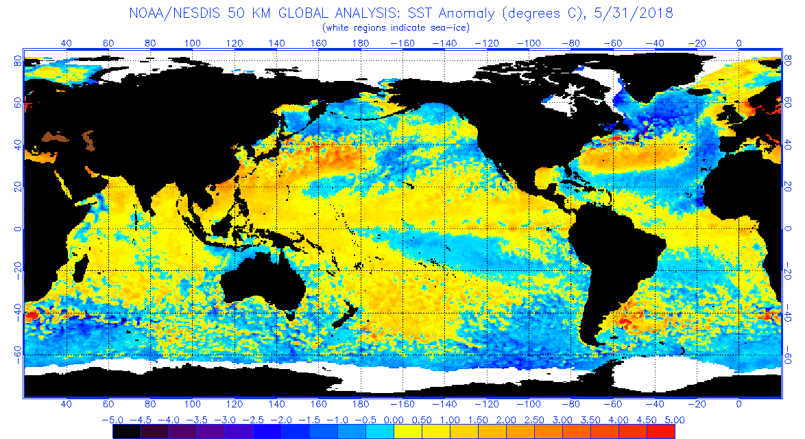
Winter '18 / '19 - Predictive Value of NW Atlantic Ocean's SST Anomalies for Winter's Phase of the North Atlantic Oscillation
Up until a few years ago ... the UKMET office issued a long-lead forecast for the phase of the upcoming winter's North Atlantic Oscillation (NAO). The forecast was based on a statistically significant correlation between May's sea-surface temperature anomalies (SSTA) in the western Atlantic ocean (depicted in the image below left) and NAO's future D-J-F phase (as depicted in the Winter Z500 pattern image below right).

To apply this technique for Winter '18 / '19; take note of the SSTA pattern in the NW Atlantic at the end of MAY-18 shown below.
- Positive anomalies off the mid-Atlantic and NE coasts.
- Negative anomalies in the Labrador Sea off Greenland's southern coast.
- Positive anomalies north of Iceland in the Norwegian Sea.

Compare these anomalies with the 'May SST pattern' map.
See how well they align?
MET Office research concluded if May's SSTA aligns generally with the prediction pattern in the western Atlantic ocean ... then the expected dominant NAO state would be positive during the upcoming winter.
Above normal SST in the offshore waters of the NE coast ... below normal water temperatures SW
of Iceland ... and positive anomalies to the northeast point to a +NAO. When
the pattern is reversed a -NAO is forecast.
Based on May-18 SSTA ... the dominant NAO state prediction for Winter '18 / '19 is positive.
There's even empirical evidence the D-J-F NAO will average above zero if NOV's NAO index is greater than zero.
Winter-season forecasters hitching their collective wagons to the +ENSO state might could want to stop-and-consider the effect of the Northern Annual Modes on their outlooks.
---
Earlier post about UKMET NAO predictive research here.
Friday, October 26, 2018

Saturday, October 20, 2018
Winter '18 / '19 - How Much For Philly?
A weak-to-moderate El Niño continues to be the consensus forecast for Winter '18 / '19.

One problem; average isn't always the best metric to describe what's typical or most likely to occur. That honor frequently falls to the median.
As such ... the median snowfall is four inches less than the 23" 51-year average suggesting this winter's season-total snowfall in Philly could very be up to seven inches more than most other winters.
Saturday, October 13, 2018
Winter '17 / '18 - Correlation of Eurasia's OCT Snow Cover and Season-total Snowfall in NE and M-A Regions
REPOST from OCT-17 (lightly edited for clarity)
Updated with Winter '17 / '18 verifications for RIC and NYC and their outlooks for Winter '18 / '19
---
The correlation between the areal coverage of Eurasia/s OCT snow cover and season-total snowfall has become broad-brushed conventional wisdom (CW) following the innovative research by AER climatologist Dr. Judah Cohen.
But ... just how well does the CW hold up for NEWxSFC/s forecast stations across New England (NE) and the mid-Atlantic (M-A) regions?
To find out ... monthly period-of-record areal snow cover data for Eurasia from Rutgers Global Snow Lab were correlated with season-total snowfall data for the 27 NEWxSFC/s stations.
A positive and statistically significant correlation means the greater the areal snow cover over Eurasia in OCT ... the greater the season-total snowfall for the following winter.
An Excel radar chart shown below depicts the results of the analysis.

Translation: greater season-total snowfall over select stations in the NE and M-A is correlated with greater OCT areal snow cover in Eurasia.
---
The analysis showed other significant correlations of interest.
- RIC/s season-total snowfall has a positive correlation with Eurasia/s AUG areal snow cover.
Eurasia/s AUG-17 snow cover was well below normal ==> lower season-total snowfall @RIC this winter.
VERIFICATION Winter '17 / '18: RIC STP 12.4" (AVG: 13.2")
OUTLOOK Winter '18 / '19: Eurasia's AUG snow cover below average ==> STP below AVG
- NYC/s season-total snowfall has a negative correlation with Eurasia's JUN areal snow cover.
Eurasia/s JUN-17 snow cover was above normal ==> lower season-total snowfall @ NYC this winter.
VERIFICATION Winter '17 / '18: NYC STP 35.4" (AVG: 26.1")
OUTLOOK Winter '18 / '19: Eurasia's JUN snow cover below average ==> STP above AVG

VERIFICATION Winter '17 / '18
Eurasia's OCT-17 areal snow cover was greater than average (12,051,667 km^2 v 10,261,134 km^2).
Positive correlations for the stations listed below suggest Winter '17 / '18 STP would be above average
STN: STP" / AVG"
ABE: 46 / 31.4
BOS: 58.6 / 41.6
BTV: 81.5 / 69.8
PWM: 91.1 / 63.8
---
FINDINGS: data analysis supports the CW for NE forecast stations but not so much across the M-A.
Thursday, October 04, 2018
Winter '17 / '18 - Arctic Oscillation (AO) Analog Verification
The analog forecasting technique seeks similarities to the AO state in the run-up to the coming winter with AO run-up states of winters past. Presented here is the verification of AO analogs for the '17 /'18 winter.
The NEWxSFC method ranks analog years by their the sum of square errors (SSE) statistic.
Lower SSE errors ==> stronger analog
Constraining the number of analog winters for analysis to five is arbitrary.
 |
| Arctic Oscillation (AO) Index Analog Forecast Verification |
A qualitative assessment of the forecast's accuracy would rate all analogs except '73 / '74 as 'poor' ... IOW ... useless.
OTOH ... analog #1 mimicked the observed behavior of the AO associated with a weak La Nina; whereas ... . strong La Nina conditions prevailed during the winters of '73 / '74.
CONCLUSION: The analog forecasting technique provided useful guidance for Winter '17 / '18.
---
 An alternative forecasting technique looks at the AO/s 'sign' (i.e., positive or negative) for any calendar-year's month preceding the pending winter as a potential leading indicator of the AO's sign for upcoming D-J-F period.
Results from a chi-square 'test for independence' infers a statistically significant relationship ... at the 95% confidence level and a p-value < 0.05 ... between NOV's AO sign and AO's sign of the upcoming D-J-F period.
IOW ... if NOV's AO is negative (positive) ... then the average AO state during the upcoming winter will also be negative (positive); although the classification model is stronger ... i.e., lower false alarm rate ... for the predictor's month with negative signs than positive. This is opposite of the relationship found for the NAO.

BOTTOM LINE: If NOV's AO is negative ... chances are good the AO state will average negative during the D-J-F period.
NOV '17 AO/s sign was negative (-0.078). The 2x2 contingency technique predicted correctly AO state for Winter '17 / '18 would average less than zero. AO for the D-J-F period averaged (0-.076).
Subscribe to:
Posts (Atom)


