Friday, October 18, 2019

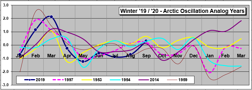
Winter '19 / '20 - Statistical Winter Outlook: Solar cycle and ENSO

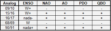
Severe Weather Europe's (SWE) analysis of the solar cycle and ENSO analogs ...


"After removing all the cold phases and strong warm phases of ENSO, we get a very interesting and more defined picture. We see a high pressure area focused over Greenland and the Arctic, typical for negative NAO & AO.

"Lower pressure is displaced a bit further south, along with polar fronts and colder air. This type of pattern usually brings colder and snowy weather to Europe and USA."

SWE/s solar cycle / ENSO analysis in general agreement with our current QBO ... AO ... and Eurasia snow cover analogs.

Saturday, October 12, 2019

Winter '19 / '20 - Quasi-Biennial Oscillation (QBO): Leading Analogs' 500 mb Anomaly Height Composite ... as of SEP-19

Analog 5H composite ('78/'79 ... '85/'86 ...'95/'96 ... '99/'00 ... '02/'03) ... as of SEP-19

- Ridge-W Trof-E
- Hi-latitude blocking ==> AO & NAO < 0
- EPO < 0

---
Analog years for Winter '19 / '20

CORRECTION:  '78 / '79 & '85 / '86 ENSO should be 'W-' & 'C-' ... respectively.
 
KEY
ENSO:  nada- (-0.5 < SSTa <  0); C- (weak La Nina); C+ (strong La Nina); W (moderate El Niño)
NAO:  sign of D-J-F average
AO:  sign of D-J-F average
PDO:  sign of O-N-D-J-F-M average

Tuesday, October 08, 2019

Winter '19 / '20 - Eurasia Snow Cover: SEP

Eurasia/s areal snow cover for SEP-19: ~1,570,000 SQ-KM

3% below 48-year P-O-R-N (~1,629,000 SQ-KM)
1% below 48-year Median (~1,588,000 SQ-KM)

Rank: 26th
4th lowest past 10 years
11 of past 20 years below median
SEP-18:  ~1,300,000 SQ-KM
SEP-19 21% greater than SEP-18


KEY
ENSO:  nada+ (0 < SSTa <  0.5); C- (weak La Nina); W- (weak El Niño); W (moderate El Niño); W+ (strong El Niño)
NAO:  sign of D-J-F average
PDO:  sign of O-N-D-J-F-M average
QBO:  + ==> west; - ==> east

Saturday, October 05, 2019

Winter '19 / '20 - Arctic Oscillation (AO): Leading Analogs' 500 mb Anomaly Height Composite ... as of SEP-19

Analog 5H composite ('53/'54 ... '54/'55 ...'59/'60 ... '97/'98 ... '14/'15) ... as of SEP-19

- Overall North American pattern mimics Tropic/Northern Hemisphere's (TNH) negative phase often associated with +ENSO.

- Positive height anomaly over eastern Canada displaces climatologically favored position of Hudson Bay trof limiting high-latitude cold air supply to the Lower 48.

- TNH associated with stronger than normal Pacific jet farther south of its normal axis and well above normal temperatures in eastern North America.


CORRECTION:  '53 / '54 ENSO should be 'W-'

KEY
ENSO:  nada- (-0.5 < SSTa <  0); C- (weak La Nina); W- (weak El Niño); W (moderate El Niño); W+ (strong El Niño)
NAO:  sign of D-J-F average
PDO:  sign of O-N-D-J-F-M average
QBO:  + ==> west; - ==> east; +/- flipped west to east

Thursday, October 03, 2019

Winter '19 / '20 - North Atlantic Oscillation (NAO): Leading Analogs' 500 mb Anomaly Height Composite... as of AUG-19

UPDATE:  SEP/s NAO did not change the analog years other than to shuffle the 4th and 5th ranks.

---
Analog 5H composite ('50/'51 ... '08/'09 ... '12/'13 ... '16/17 ... '17/'18) ... as of AUG-19


- Another round of Trof West - Ridge East

- EPO-like ridge offset slightly to the west of preferred position for a 'Trof-East' regime

- Azores HIGH suggests NAO > 0

- Negative height anomaly over south-central Canada favors primary storm track through the Upper Plains and across the Great Lakes in line with current soil moisture axis.


Winter '19 / '20 NAO analog analysis here.

Saturday, September 28, 2019

Winter '19 / '20 - Eurasian Snow Cover: AUG

Eurasia/s areal snow cover for AUG-19:  ~158,300 km2


-61% below 48-year P-O-R-N (~403,000 km2)
-46% below 48-year Median (~294,000 km2)
Rank: 39th

7th highest past 10 years
19 of past 20 years below median
 Last year:  ~140,800 km2

Analog years for winter '19 / '20
CORRECTION:  Second instance of 15/16 should be 16/17
---
Snow cover data courtesy Rutgers University Global Snow Lab
http://climate.rutgers.edu/snowcover/index.php

Thursday, September 26, 2019

Winter '19 / '20 - Arctic Oscillation (AO): AUG

AUG AO:  -.722
Leading analog contenders ... as of AUG-19.


Consensus Outlook:  Winter '19 / '20 AO < 0

KEY
ENSO:  nada- (-0.5 < SSTa <  0); C- (weak La Nina); W- (weak El Niño); W (moderate El Niño); W+ (strong El Niño)
NAO:  sign of D-J-F average
PDO:  sign of O-N-D-J-F-M average
QBO:  + ==> west; - ==> east; +/- flipped west to east

---
Present state
ENSO: 0 < ONI < 0.5 trending lower
NAO < 0 past 5 months
QBO > 0 past 10 months.  Peaked JUN-19; trending lower.  Possible flip during upcoming winter
PDO (MAR-18 to OCT-19) < 0 No trend.

Wednesday, September 25, 2019

Winter '19 / '20 - North Atlantic Oscillation (NAO): AUG

AUG NAO:  -1.17
Leading analog contenders ... as of AUG-19.

Consensus Outlook:  Winter '19 / '20 NAO > 0

CORRECTION:  '50 / '51 ENSO should be 'C-'

KEY
ENSO:  nada- (-0.5 < SSTa <  0); C- (weak La Nina); C (moderate La Nina)
AO:  sign of D-J-F average
PDO:  sign of O-N-D-J-F-M average
QBO:  + ==> west; - ==> east

---
Present state
ENSO: 0 < ONI < 0.5 trending lower
QBO > 0 past 10 months.  Peaked JUN-19; trending lower.  Possible flip during upcoming winter
PDO (MAR-18 to OCT-19) < 0 No trend.

Saturday, September 14, 2019

Winter '18 / '19 - North Atlantic Oscillation (NAO) Analog Verification

The analog forecasting technique seeks similarities to the NAO state in the run-up to the coming winter with NAO run-up states of winters past.  Presented here is the verification of NAO analogs for the '18 /'19 winter.

The NEWxSFC method ranks analog years by their the sum of square errors (SSE) statistic.
Lower SSE errors ==> stronger analog

Constraining the number of analog winters for analysis to five is arbitrary.

North Atlantic Oscillation (NAO) Index Analog Forecast Verification

In the run-up to Winter '18 / '19 ... '84 / '85 was the leading analog followed by '72 / '73 ... '59 / '60 ... '89 / '90 ... and '91 / '92.  Winter '18 / '19 NAO started weakly positive ... approached zero at meteorological winter's end ... then climbed above 1 in MAR.

A qualitative assessment of the analog forecast's accuracy would rate the analogs #2 or #5 as 'best' with #1 ... 3 ... and 4 'poor.'

A quantitative assessment of the other '72 / '73 and '91 / '92 teleconnections ... not so much.

Wednesday, August 21, 2019

Winter '18 / '19 - Arctic Oscillation (AO) Analog Verification

The analog forecasting technique seeks associations to the AO state in the run-up to the coming winter with AO run-up states of past winters.  Presented here is the verification of AO analogs for the '18 /'19 winter.

The NEWxSFC method ranks analog years by their the sum of square errors (SSE) statistic.
Lower SSE errors ==> stronger analog

Constraining the number of analog winters for analysis to five is arbitrary.

In the run-up to Winter '18 / '19 ... '55 / '56 was the leading analog followed by '64 / '65 ... '84 / '85 ... '99 / '00 ... and '91 / '92.  Observed AO values for Winter '18 / '19 began neutral in DEC ... turned weakly negative in JAN ... then surged positive at meteorological winter/s end and into MAR.

A qualitative assessment of the analog forecast/s accuracy rates '84 / '85 as best.

A quantitative assessment of the other '84 / '85 teleconnections ... not so much.