Tuesday, February 16, 2021

Winter '20 / '21 - Snow Storm #4: Call for Forecasts! - Take 2

Boston Public Garden
25-FEB-62

Too few stations stayed in play after Storm #4/s first Call for Forecasts on SUN.

This storm shows much more promise to have more than enough forecast stations in play to be contest-worthy.

One thing remains unchanged from - the parade of winter storms affecting the M-A and the NE with messy p-types.

Enter your forecast at the NEWxSFC/s home page at http://www.newx-forecasts.com/

Follow the top-of-page link from 'Enter Snow Storm Forecast'

---
Forecast element: each station/s storm-total snowfall

Deadline for entries: 10 PM EST ... WED ... 17-FEB-21
Verification begins: 12:01 AM EST ... THU ... 18-FEB-21
Verification ends: 11:59 PM EST the day when snow stops accumulating

Sunday, February 14, 2021

Winter '20 / '21 - Snow Storm #4: Call for Forecasts!

BWI
Columbia Ave.  (13-FEB-1899)

UPDATE 4:30 PM EST ... MON ...15-FEB-21

Not happenin' ...

UPDATE 10:45 AM EST ... MON ...15-FEB-21
Trend not being very friendly ... 

---
Original post (5:13 PM EST ... SUN ...14-FEB-21)

Contest-worthy snows expected along the NW edge of the precipitation shield as the next in a parade of winter storm slides east across the northern M-A then off the SNE coast.  Messy p-type forecasts downstate.

Enter your forecast at the NEWxSFC/s home page at http://www.newx-forecasts.com/

Follow the top-of-page link from 'Enter Snow Storm Forecast'

---
Forecast element: each station/s storm-total snowfall

Deadline for entries: 10 PM EST ... MON ... 15-FEB-21
Verification begins: 12:01 AM EST ... TUE ... 16-FEB-21
Verification ends: 11:59 PM EST ... TUE ... 16-FEB-21

You also get the chance to see how well your forecast stacks up against NWS Eastern Region Weather Forecast Offices. Turns out they/ve been fairly easy to beat!

Saturday, February 13, 2021

Winter '20 / '21 - 'Season-total' Snowfall Forecast Contest: JAN Totals


Mass General Hospital (06-FEB-61)

UPDATE 14-FEB-21 4 PM EST:  corrected JAN total for EWR ... NYC ... BDR and JAN Forecast Station Highlights section.

h/t Roger Smith

---
JAN-21 snowfall summary by forecast station.

Rank-ordered descending by percent of monthly period-of-record-normal
(%JAN)


Green ==> 4th quartile
White ==> Inter-quartile range
Red ==> 1st quartile

---
JAN Forecast Station Highlights
3 stations with above normal monthly snowfall

BTV
4.1" (21%) above JAN normal

ORF
0.2" (6%) above JAN normal

SBY
0.2" (6%) above JAN normal

Biggest Losers

PWM ... CON (less than 35% JAN P-O-R-N)

---
Season-Total-to-Date

JAN P-O-R-N contributes 279" (30%) toward the season-total snowfall (D-J-F-M) of 929".

JAN-21 observed snowfall:  212" (-44% below P-O-R-N; 17% of season-total snowfall)

Image courtesy NOHRSC @ http://www.nohrsc.noaa.gov/nsa/

---
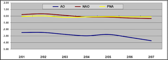
Teleconnections

AO / NAO / PNA data
https://www.cpc.ncep.noaa.gov/products/precip/CWlink/pna/daily.index.ascii

---
DEC Totals
https://newxsfc.blogspot.com/2021/01/winter-20-21-season-total-snowfall.html

Thursday, February 11, 2021

Winter '20 / '21 - Snow Storm Contest: Interim Standings #1

After three snow storm forecasting contests ... under the ‘two-thirds’ rule … forecasters who have entered at least TWO forecasts are included in interim standings #1.


Complete interim statistics table and chart at the Contest/s web site HERE (direct link)
Forecaster statistics for Winter '20 / '21 contest snow storms HERE (direct link)

Don Sutherland has been identified incorrectly as the Chief 'Regular Season' forecaster for the '20 / '21 season when that honor belongs to Brad Yehl.  We regret the error and apologize to Brad for the oversight.

---
SUMSQ errors for each contest snow storm are normalized (i.e., standardized) with a 'Z-score' ... then averaged to compute the standings. If a forecaster has issued forecasts for more than two-thirds of all snow storm contests ... then Z-scores from their 'best two-thirds' forecasts are used to calculate the Interim and Final standings.  Similar idea as dropping the lowest test score before computing the final grade.

Tuesday, February 09, 2021

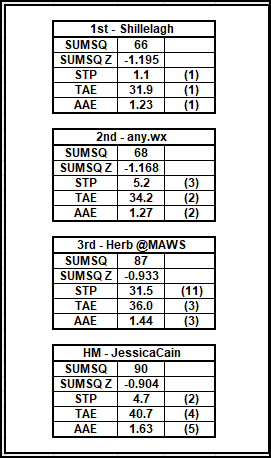
Winter '20 / '21 - Snow Storm #3: FINAL Results

Complete forecaster verification table and the FINAL Results / Storm Summary available at NEWxSFC/s home page.


SUMSQ:  sum of square error (")
SUMSQ Z:  Z-score
STP:  storm total precipitation error (")
TAE:  total absolute error (")
AAE:  average absolute error (")
(#):  category rank

Forecast by Observed Snowfall Scatterplots for Top Forecasts
Forecast/s dotted blue line below (above) the Observed snowfall/s solid red line ==> under (over) forecast error.

Station by Station Comparison of Top Forecasters

Monday, February 08, 2021

Winter '20 / '21 - Snow Storm #3: Preliminary STP Verification

Accumulation-weighted SN:H20 (SLR)

Preliminary verification of storm-total snowfalls for SUN and MON from CDUS41 (CLI) ... CXUS51 (CF6) ... METARs ... and PNS bulletins.  Excellent coverage and reporting.

HYA STP estimated by applying inverse distance weighting interpolation of three timely reports within 3.5 SM of the station carried by the PNS bulletin from BOX.

SBY STP estimated based on one report from the forecast station/s county (Wicomico) carried by AKQ/s PNS bulletin.

---
SLR not reported for some stations with measurable snowfall b/c significant liquid and / or freezing precipitation also occurred during the verification period.

Sunday, February 07, 2021

Winter '20 / '21 - Snow Storm #3: The Forecasts!

NYC
Summit Hotel on Lexington Ave
07-FEB-67
Forecasters
Rookie      2
Intern      -
Journey      -
Senior      18
GOVT      1
PWSP      1
TOT      22

---
Forecasters rank-ordered by ascending storm-total precipitation (STP)

BLUE ==> 1st quartile
RED ==> 4th quartile
WHITE STP cells fall between the 1st and 4th quartiles

Heaviest snowfall (+5") consensus along and to the right of ISP - BDR - ORH - BOS - HYA - ISP
Lollypop expected at PVD (5.8")

Two out of three teleconnections on vacay.

Forecasters' station-by-station forecasts posted to the Contest/s web site here.
http://www.newx-forecasts.com/

Direct link to the table of forecasts here.
http://www.newx-forecasts.com/NEWxSFC_22/storms/storm3_forecasts_07FEB21.htm

Winter '20 / '21 - Snow Storm #1: NESIS

The Northeast Snowfall Impact Scale (NESIS)


Friday, February 05, 2021

Winter '20 / '21 - Snow Storm #3: Call for Forecasts!

BOS
04-FEB-40
Took a while for this winter to get a'goin' but we're underway with the second contest-worthy snow storm in a week/s time.

The fast-moving Miller 'A' nor'easter on the menu progged to race from the Gulf of Mexico toward the VA Capes then up the northeast coast ducking just under the 40/70 Benchmark on its way out to sea.

Enter your forecast at the NEWxSFC/s home page at http://www.newx-forecasts.com/

Follow the top-of-page link from 'Enter Snow Storm Forecast'

---
Forecast element: each station/s storm-total snowfall
Deadline for entries: 10:00 PM EST ... SAT ... 06-FEB-21
Verification begins: 12:01 AM EST ... SUN ... 07-FEB-21
Verification ends: 11:59 PM EST on the day when flakes stop accumulating.

You also get the chance to see how well your forecast stacks up against NWS Eastern Region Weather Forecast Offices. Turns out they/ve been fairly easy to beat!

---
If you are issuing your first forecast this winter ... or you entered the 'season-total' forecast contest ... you/ll need to create an account -- user name / password / valid e-mail (if you want a copy of your forecast sent to your Inbox).

The forecasting contest for Snow Storm #3 may be cancelled prior to the deadline if at least 6-to-8 stations are unlikely to observe at least a 4" storm-total snowfall.

---
As always ... there/s no cost ... no fee ... no advertising ... or annoying requests for personal information to enter a forecast. It/s just a fun exercise for winter wx enthusiasts to see who can make the best synoptic-scale snowfall forecast.