Tuesday, February 17, 2009

Late Winter Rally

PhotobucketWhat could portend the start of a late winter rally and extra innings into March...the global models today were again dangling shiny objects before our eyes in their medium range forecasts.

Today/s ECMWF depicts an amplifying long-wave pattern over the CONUS beginning in a few days...with low-latitude cyclogenesis occurring ahead of a positively-tilted trof...and a potent nor'easter attending arctic HIGH pressure in the chamber for the last week of meteorological winter.

GooFuS offering up a similar idea...albiet a different evolution...as well.

Last snowfall forecasting event was almost three weeks ago. High time for another.

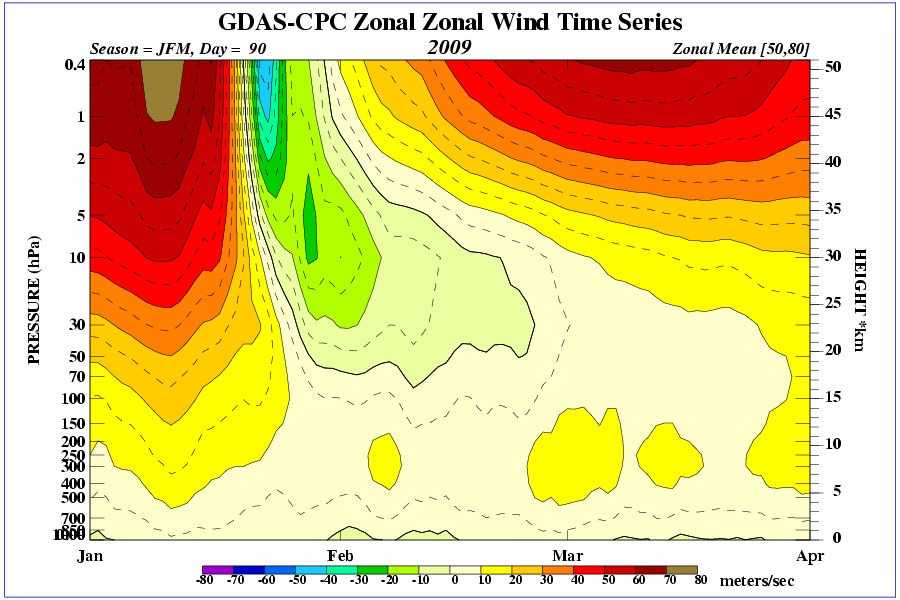
Once the storm passes...NWP suggests another arctic outbreak in the offing.

Note the deep-layer easterlies at high latitude (negative zonal wind (u) at 500 mb ==> flow into the board)...evidence of a very weak / non-existent polar vortex...and an easterly arctic jet at 10 m/s...both of which indicate favorable conditions for an arctic outbreak into the mid-latitudes.

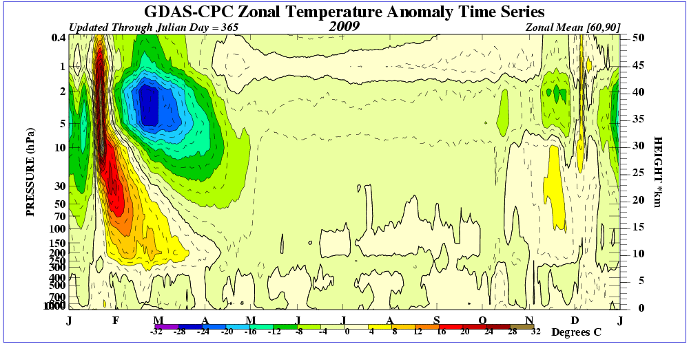
Is this the manifestation to the sudden warming of the stratosphere observed at the end of January? If so...the timing would be right on schedule.

Also interesting is the ~10 m/s west wind over the equator in the 30 / 50 mb layer...evidence of QBO-west maintaining its strength.

Wednesday, February 11, 2009

Sudden Stratospheric Warming - 1985 v. 2009

The most recent SSW of similar magnitude to the one occurring now...as far as depth of penetration toward the troposphere was 1985. That event started late DEC 1984 and persisted for about 4 weeks.

Here/s how the 10 mb level looked that go'round...

Photobucket

The anti-cyclonic circulation dominated for all of two days.

Contrast and compare to current events...

Photobucket

The 2009 event is much more robust than what happened in 1985....lasting at least 7x longer. Remember also...the on-going SSW is happening while QBO is west (positive) and the solar cycle is at minima...a rare convergence of events...indeed.

Previous posts on the 2009 SSW event here.

VCP 32 - Hard Work and Originality

Pattern Change Ahead?

The predominant storm track this winter has been up the spine of the Appalachian Mountains with a secondary axis established in DEC a bit farther north and west from MO through MI.

NWP has been advertising a change in recent runs...shifting the axis to the south and east...possibly the result of a robust -NAO state suppressing the storm track toward lower latitudes and offering the prospect of winter weather for the snow-starved mid-Atlantic region. The forecast for change dove-tails nicely with the climatological peak for snowfall in this area.

The first...and weakest...in a series of waves is progged to move through the southeastern states this weekend...primarily as a rain maker with some snow under the northern edge of the precipitation shield...followed by a second...stronger LOW southern portions of the mid-Atlantic early next week...followed by another... stronger wave a few days later. Going beyond that is getting deep into fantasy-land; however...the models currently show two more storms to round out the month.

Trends have shown better cold in the lowest layers and HIGH pressure positioned north of some surface LOWs. The fact that the models aren/t showing 'perfect' setups at this time-range is all the more reason to be optimistic.

While we wait for events to unfold...give a read to the post by Baltimore Sun/s Frank Roylance about the historic Blizzard of FEB 10...1899.

Saturday, February 07, 2009

Sudden Stratospheric Warming - Mother Lode of Cold

Vortex reversal @ 10 mb was observed around JAN 27. Easterlies propagated steadily through 30...50...70...and close to 100 mb at post time. Warming has reached the tropopause near 300 mb.

Given there/s ~3-4 week lag between SSW-onset and its effects affecting the troposphere...LR progs are beginning to suggest the magnitude of the cold mother lode and the location where it will be observed.

Note the cold temperatures at 90°N in the D+10 latitude-height cross section. Top-o-world 1000 mb temperature -30°C! (-22°F) Coldest forecast temperature this winter. The warm bubble over 90°N @ 200 mb is the remnant of descending warm stratospheric air. Note the slope of the temperature gradient between 80°N and 90°N near 500 mb...evidence of an arctic jet.

The North Atlantic Oscillation (NAO) plunges...accordingly. 5 to 7 standard deviations below normal. Wowser! Should NAO come anywhere near those levels...it would be abso-fookin' historic. The lowest daily NAO value from a CPC dataset beginning in 1950 is -3.254.


The always reliable D+14 GooFuS blocking forecast suggests mega-blocking over Baffin Bay / Greenland....with significant winter weather implications for the eastern CONUS.

Apparently...Meteorlogix in Woburn...MA didn't get the memo until today.

From the JAN 28th edition of the Nashua Telegraph...

"I do not see significant changes in the overall pattern we've had," Doug Webster of Hudson, senior meteorologist with Meteorlogix said.

If that's the bad news for the rest of winter, the good news is that Webster doesn't see us having another "severe cold snap" like the one that hit last week."
Different story today...

Doug Webster...
"The outlook for the remainder of the winter and early spring could hinge on recent events many miles above the polar landscape. During the end of January, an event known as Sudden Stratospheric Warming took place.

[...]

"Past history (ed. Is there any onther kind?) shows that when strong SSW occurs, wintry weather expands southward into the mid latitudes around the globe for a one- to two-month period.

[...]

"Given these possibilities, wintry weather could again become a fairly big story across much of the nation later this winter and into the spring.

"Past research (ed. Is there any other kind?) shows the lag time for the start of the more wintry weather regime is apparently on the order of two to three weeks after the SSW event. So enjoy the milder weather of the next week or so, because winter may return with some force during the second half of February and beyond."

Thursday, February 05, 2009

Sudden Stratospheric Warming - Update

A negative zonal wind is an east wind...flowing into the board. It reflects the anti-cyclonic circulation aloft...and at post time...there/s evidence of a polar surface HIGH...as well.


Temperature time-height section reveals the depth of stratospheric warming anomaly has reached ~300 mb...a reasonable approximation of the tropopause. Wiki.


SSW can lead to arctic outbreaks ~4 weeks after the event...which would happen around the third week of February. The ECMWF puts the cold air over the prime meridian in 10 days. Question is...where will the brunt of the cold set up in the days to follow and will significant disturbed weather ensue?

With a low tropopause height...tropopause folding could cause a surface cyclone to really spin-up as stratospheric vorticty becomes entrained into the storm complex.

Wednesday, February 04, 2009

NOAM Temperature Departures - January '09


The negative temperature departures observed in December sagged south and east from south-central Canada into the Great Lakes region and New England in January. Warm anomalies switched coasts in response to higher 500 mb geo-heights in the west and lower heights in the east along the predominant storm track. A number of high-profile seasonal forecasts expected mild temperatures in the east...highlighting the difficulty of beating the house.


Positive precipitation departures were observed over Canada/a west coast and along the spine of the central Appalachia.


Cumulative temperature and precipitation anomalies...season-to-date.


Plots courtesy ESRL - Physical Sciences Division

Tuesday, February 03, 2009

Snowfall Summary - January '09

January/s storm track continued to favor New England/s coastal and piedmont stations.

Concord (CON)...ranked first among all contest forecast stations...measured 186% of their monthly normal (17.8")...just shy of the 193% relative to normal snowfall observed in December. January/s 33.1" snowfall is 57% of their total winter snowfall (D-J-F-M). So far this winter...CON has 60.7" in the snow bank.

Boston (BOS) was second again in January...with 185% of normal monthly snowfall (12.8"). Boston ranked second in December with 316% of normal (8"). 58% of their normal winter snowfall occurred in Janaury. BOS two-month total stands @ 49".

Other notable monthly snowfall were Bridgeport (BDR) with 13.7" (183% monthly normal) and Bangor (BGR) with 175%.

Fifteen stations observed more than their normal monthly snowfall for January...including Raleigh (RDU) @ 125%.

Biggest losers were in the mid-Atlantic region again this month...and as was the case all of last season.

Green => Top 25%
Red => Bottom 25%

WFO Monthly/Daily Climate Data

NCDC Period-of-Record Snowfall Climatology

Monday, February 02, 2009

Sunday, February 01, 2009

Interim Standings

After seven snow storms... donsutherland1 holds the lead... shanabe moves back into second...and Donald Rosenfeld...hot off two straight wins...advances to third.

Several forecasters ranked in previous Interim Standings had not entered at least five forecasts and were not eligible for this summary under the ‘two-thirds’ rule.

Full interim forecaster error statistics table and charts here.

Forecaster storm summary data here.

SUMSQ errors for each contest snow storm are normalized with a 'Z-score'...then averaged to compute the standings. Forecasters who have entered at least 2/3 of all snow storm contests are included in the standings.

If a forecaster has participated in more than two-thirds of all snow storm contests...then Z-scores from two-thirds of their best forecasts are used to calculate Interim and Final standings. Same idea as dropping the lowest quiz score before the final grade is computed.

Previous Interim summary here.