Saturday, December 19, 2020

Winter '20 / '21 - Snow Storm #1: FINAL Results

Forecaster verification table and the FINAL Results / Storm summary available at NEWxSFC/s home page.

SUMSQ:  sum of square error (")
SUMSQ Z:  Z-score
STP:  storm total precipitation error (")
TAE:  total absolute error (")
AAE:  average absolute error (")
(#):  category rank

Forecast by Observed Snowfall Scatterplots for Top Forecasts
Forecast/s dotted blue line below (above) the Observed snowfall/s solid red line ==> under (over) forecast bias.

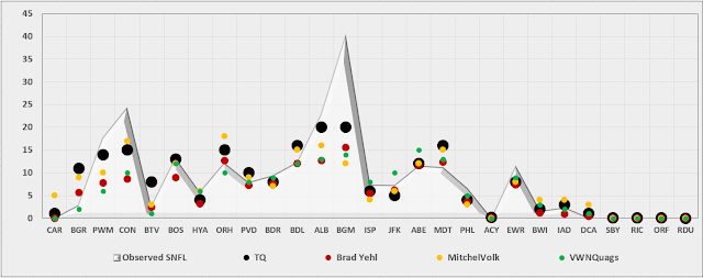
Station by Station Comparison of Top Forecasters

Friday, December 18, 2020

Winter '20 / '21 - Snow Storm #1: Preliminary STP Verification

Accumulation-weighted SN:H2O

Preliminary verification of storm-total snowfalls for WED and THU from CDUS41 (CLI) ... CXUS51 (CF6) ... METARs ... and PNS bulletins.  Excellent coverage and reporting.

HYA STP estimated by applying inverse distance weighting interpolation of five timely reports within 3 SM of the station carried by the BOSPNS bulletin.

---
SLR not reported for some stations with measurable snowfall b/c significant liquid and / or freezing precipitation also occurred during the verification period.

---
Stations observing >= 0.1"  20 (74%)

Given a station had measurable snowfall; stations observing at least ...
4" - 16 (76%)
8" - 11 (53%)
12" - 7 (33%)
18" - 3 (14%)
24" - 2 (10%)

MAX snow melt-water (minimum SLR 10:1)
BGM:  2.8"
ALB:  2.0"
BOS:  1.3"

MAX liquid precipitation (frozen + freezing + liquid):
BGM:  2.8"
ACY:  2.06"
ALB:  2.0"

---
New daily record(s)
16-DEC-20
BDR - 6.5" (2"; 1970)
ISP - 5.7" (1.5"; 1995)
JFK - 3.8" (1.3"; 1981)

17-DEC-20
BGM - 26.4" (9.8"; 1973)
CON - 24.2" (8.6"; 1970)
ALB - 19.7" (11.1"; 1970)
BOS - 12.7" (6.4"; 2013)
ORH - 10.5" (9.9"; 1970)
BDL - 7.8" (6.5"; 2016)
PVD - 6.4" (4"; 1961)
EWR - 5.9" (3"; 2016)
JFK - 3.4" (3"; 2016)

Storm total snowfall
Image courtesy NOHRSC

SFC analysis:  09z ... 17-DEC-20
Image courtesy DOC / NOAA / NWS / NCEP / WPC

---
Please report any errors in Comments along with a link to the correct data.
FINAL results expected NLT SAT evening.

Wednesday, December 16, 2020

Winter '20 / '21 - Snow Storm #1: The Forecasts!

MDT
07-FEB-67


Forecasters

Rookie     2
Intern       1
Journey    1
Senior      15
GOVT     1
PWSP      1
TOT        21

NEWxSFC welcomes Rookie Forecasters NJTom and Leigh Rosenthal along with our returning veterans.  Congratulations to Briannavaught for her promotion to Intern Forecaster and kc2dux to Journeyman Forecaster.

Don Sutherland retains his title as Chief Forecaster this winter b/c there was only one 'contest-worthy' snow storm last winter -- minimum three storms required -- to hold a valid contest and declare a winner.

---
Forecasters ranked by ascending storm-total precipitation (STP)

BLUE ==> 25th percentile
RED ==> 75th percentile
WHITE STP cells range between the 25th and 75th percentile 

Monday, December 14, 2020

Winter '20 / '21 - Snow Storm #1: Call for Forecasts!

NYC
19-DEC-45

Rousing start to NEWx/s 22nd Annual 'Snow Storm' Forecasting Contest!

Rapidly deepening coastal LOW ... cold air damming ... and a potent fast-moving mid-level short wave combine mid-week for a rare 'contest-worthy' event in DEC.

Everyone is welcome to enter a forecast.

You also get the chance to see how well your forecast stacks up against NWS Eastern Region Weather Forecast Offices.  Turns out they/ve been fairly easy to beat!

Forecast element: each station/s storm-total snowfall

Deadline for entries: 10:00 PM EST ... TUE ... 15-DEC-20
Verification begins: 12:01 AM EST ... WED ... 16-DEC-20
Verification ends: 11:59 PM EST on the day when accumulating flakes stop flyin'.
---
Enter your forecast at the NEWxSFC/s home page at http://www.newx-forecasts.com/
Follow the top-of-page link from 'Enter Storm Forecast.'

If you are issuing your first forecast this winter ... or you entered the 'season-total' forecast contest ... you/ll need to create an account -- user name / password / valid e-mail (if you want a copy of your forecast sent to your Inbox).

The snowfall forecasting contest for Snow Storm #1 may be cancelled prior to the deadline if at least six-to-eight stations are unlikely to observe at least a 4" storm-total snowfall.

---
As always ... there/s no cost ... no fee ... no advertising ... or annoying requests for personal information to enter a forecast. It/s just a fun exercise for winter wx enthusiasts to see who can make the best synoptic-scale snowfall forecast.

Thursday, December 10, 2020

Winter '20 / '21 - North Atlantic Oscillation (NAO): Analog Composites of 500 mb Height and 2-meter Temperature Anomalies ... as of NOV-20

 NOV:  +2.54 🔥🔥🔥
Only two other NOVs had a higher index ('78 +3.04; '93 +2.56)

TL;DR  This winter/s average NAO index expected to be positive ( >0 ).

---
Analogs and weights for composites:

'03 / '04 (1)
'99 / '00 (1)
'91 / '92 (1)
'93 / '94 (1)
'15 / '16 (1)

Each analog's average NAO for D-J-F was > 0.

NAO/s analog winters are assessed against the upcoming winter/s expected states of:
- ENSO (MEI moderate - trending weak La Nina)
- QBO-W < 10
- PDO (cool)

We removed '03 / '04 ... '91 / '92 ... and '15 / '16 from further consideration b/c they were +ENSO winters.  Winter '93 / '94 had QBO-E so it too drops out.

Winter '99 / '00 survives with its weak La Nina --- QBO-W < 10 ... and a cool PDO.

Sunday, December 6, 2020

Winter '20 / '21 - Snow Storm #1: Contest-worthy or What?

The winter/s first nor'easter has moved into the Canadian Maritimes but not before laying down an impressive stripe of early season snowfall across northern portions of the forecast area.

On occasion the prestorm NWP output and expert guidance suggest a snowstorm will not be contest-worthy only to turn out to have been a contender.

Did NEWxSFC miss the call on this one?

Not every snowstorm expected to affect the forecast area will trigger a contest. The criteria applied to decide whether a storm is contest-worthy are loosely defined as one expected to:

- Affect at least six to eight forecast stations ...
- Produce more than a nuisance snowfall (>= 4") ...
- Be well progged by NWP ~36 to 48 hours before snow is observed at any one station.

So ... did the weekend storm rise to the occasion or fall short as expected?

Tuesday, December 1, 2020

Winter '20 / '21 - 20th Annual 'Season-total' Snowfall Forecasting Contest: The Forecasts!

Forecasters:  22

Forecasters also compete against the Period-of-Record-Normal (P-O-R-N) and Consensus.
Forecaster table ranked by season-total snowfall


BLUE - <= 25th percentile
RED - >= 75th percentile
ORANGE - Chief 'Season-total' Forecaster
P-O-R-N - period of record normal
CONSENSUS - median station forecasts

Some forecasts have decimal values and are recorded for verification purposes as such; however ... rounding was applied for display purposes only.

Saturday, November 28, 2020

Winter '20 / '21 - 20th Annual 'Season-total' Snowfall Forecast Contest: Call for Forecasts!

NEWxSFC/s Director of Season-total Snowfall Forecasting
Here comes winter with its oscillating Arctic and North Atlantic indexes ... sudden stratosphere warmings ... so-so ENSO ... and if we/re lucky .... an endless parade of 'Miller A' LOWs raking the eastern seaboard.

NE.Wx/s 20th Annual ‘Season-total' Snowfall Forecast Contest is the absolute best ... biggest ... and possibly ONLY chance to be recognized for your astute long-range forecasting acumen ;/

And it's s-o-o easy.
Cool prizes ... too!

All you have to do is issue the best forecast for the 'season-total' snowfall at 25 east coast stations between RDU and CAR!

---
Forecast element:
season-total snowfall @ each station

Forecast period:
01-DEC-20 through 31-MAR-21

Error statistic: total absolute error
[Σ abs(forecast - observed)]

Verification:
NWS climate reports (CLM or CF6)

Low. Score. Wins.

Deadline for entries: MON ... 30-NOV-20 @ 11:59 PM EST (01-DEC-20 @ 4:59 UTC)

Visit the Contest's website to enter your forecast.
Follow the link at the top right corner of the page to 'Enter Season-total Forecast.'

Update your forecast as often as you want prior to the deadline.
Only your last entry gets verified.

Wednesday, November 25, 2020

Winter '20 / '21 - Temperature and Precipitation Characteristics for CONUS During La Niña Winters Since 1950

No surprise ... all cool ENSO winters are not created equal.
Some are weak or moderate or strong.
Some associated with QBO-East and some with QBO-West.

During the analysis period between 1950 and 2012 ... most La Niña winters occurred with QBO-E.
Of the winters depicted below ... 15 of the 21 (~71%) were QBO-E.

QBO for winter '20 / '21 will be west.
Probably a moderate La Niña through mid-winter.

Saturday, November 21, 2020

Winter '20 / '21 - Season-total Snowfall Anomalies During La Nina Winters

 Taken at face value M-A snow crows suffer the most ...

The NOAA analysis of Rutgers' Global Snow Lab data does not account for the different categories of La Nina episodes (weak ... moderate ... strong) and it has an end date of 12 years ago.  Since then ... there have been three La Nina winters - '10 / '11 ... '11 / '12 ... and '17 / '18.

Relative to season-total snowfall at 28 NEWxSFC stations ...
'10 / '11 - well above average (moderate La Nina)
'11 / '12 - well  below average (weak La Nina)
'17 / '18 - above average (weak La Nina)

 Image courtesy NOAA Climate

Winter '20 / '21 - Outlooks

Thread updated periodically as new outlooks and forecasts become available from a variety of credible sources.

---

CDC - NOV ...


Wednesday, November 18, 2020

Winter '20 / '21 - Multivariate ENSO Index (MEI): Analog Composites of 500 mb Height and 2-meter Temperature Anomalies ... as of SEP / OCT-20

 Analogs and weights for composites:
'70 / '71 (24)
'07 / '08 (5)
'88 / '89 (1)
'95 / '96 (1)
'64 / '65 (1)


 We assess the MEI analog winters with the upcoming winter/s expected states of ENSO (moderate-to-strong La Nina) ... QBO-W ... and (cool) PDO.

Seeing how statistical and dynamic models predict a moderate La Nina this winter ... '64 / '65 and '95 / '96 don/t match the expectation which leaves '70 / '71 ... '07 / '08 ... and '88 / '89 as problem children.

Two concerns about the utility of winters '70 / '71 ... '07 / '08 ... and '88 / '89 ...
Two analogs depict a late winter La Nina intensification (vice expected fade) ... all three had QBO - E contrary to this winter's QBO-W ... and sadly no composites nor forecast guidance. 

MEI analog data table (unranked)
Analog statistic (not shown):  sum of squared errors

The MEI is based on five variables:
Sea level pressure (SLP)
Sea surface temperature (SST)
Surface zonal winds (U)
Surface meridional winds (V)
Outgoing Longwave Radiation (OLR)

Tuesday, November 10, 2020

Winter '20 / '21 - North Atlantic Oscillation (NAO): Analog Composites of 500 mb Height and 2-meter Temperature Anomalies ... as of OCT-20

Analogs and weights for composites:
'61 / '62 (2)
'91 / '92 (0)
'95 / '96 (0)
'99 / '00 (1)
'03 / '04 (0).

Two analogs averaged < 0 over D-J-F
Three analogs averaged > 0 over D-J-F
Little in the way of consensus which isn/t especially unusual for analogs.

We assess NAO/s analog winters with the upcoming winter/s expected states of ENSO (moderate-to-strong La Nina) ... QBO-W ... and (cool) PDO.

Recall ... '95 / '96 of 'Storm of the Century' fame was one of the better winter/s evah; however ... despite its weak La Nina profile ... its QBO-E and warm PDO eliminates the strongest calculated match for Winter '20 / '21 from the running.  Analog weight:  0

'91 / '92 drops out as well b/c its winter had a strong a El Niño ... QBO-E ... and a warm PDO.  The '03/'04 La Nada winter doesn't make the cut either.  Analog weights:  0

The two remaining winters '61 / '62 and '99 / '00 are strong analogs for Winter '20 / '21.  Both were moderate La Nina (per MEI) ... QBO-W < 10 ... and a cool PDO.  '61 / '62 set snowfall records in more than a few stations. Analog weight: 2

Season-total snowfall for '99 / '00 was above average for southern mid-Atlantic stations and generally below average elsewhere.  Analog weight:  1

---
The 500 mb and 2m T weighted analyses below are based on the winters of '61 / '62 and '99 / '00.

North Atlantic Oscillation (NAO) analog composites of 500 mb (5H) geopotential height anomalies (GPHa) and 2-meter air temperature anomalies (2m Ta) for Winter '20 / '21.

5H GPHa weighted-composite

Main features:
La Nina ridge over SE CONUS
-PNA
Positive geopotential height anomaly south of Greenland ==> -NAO (??? lo-lat action center)
Storm track across northern CONUS

2m Ta weighted-composite

Main features:
Above normal temperature across the Deep South and SE CONUS
Cold AK ==> warm East


NAO analog data table (unranked)
Analog statistic (not shown):  sum of squared errors


Monday, November 9, 2020

Winter '20 / '21 - Arctic Oscillation (AO): Analog Composites of 500 mb Height and 2-meter Temperature Anomalies ... as of OCT-20

 Analog years and weights for composites:
'89 / '90 (3) ... '90 / '91 (2) ... '97 / '98 (2) ... '02 / '03 (1) ... and '15 / '16 (1).

Sadly ... all analog years were +ENSO winters; not something expected this season so they're of limited utility.

Arctic Oscillation (AO) analog composites of 500 mb (5H) geopotential height anomalies (GPHa) and 2-meter air temperature anomalies (2m Ta) for Winter '20 / '21.

5H GPHa weighted-composite

2m Ta weighted-composite

AO analog data table (unranked)
Analog statistic (not shown):  sum of squared errors


Tuesday, November 3, 2020

Winter '20 / '21 - Eurasia Snow Cover: OCT

~ 11,000,000 SQ-KM


Under-performing all year ... 

6% above P-O-RN (~10,320,000 SQ-KM)
9% above median (~10,080,000 SQ-KM)
Period-of-Record:  53 years
Rank: 19th

2nd lowest past 10 years
16 of past 20 years above P-O-R-N

OCT-19:  ~12,700,000 SQ-KM
OCT-20:  14% less than last year

Eurasia snow analog years offer little if any guidance given this winter should have cool ENSO / PDO and QBO-W.

---
P-O-RN ==> period-of-record normal

Data courtesy Rutgers University Global Snow Lab
http://climate.rutgers.edu/snowcover/index.php

Sunday, October 4, 2020

Winter '20 / '21 - Severe Weather Europe: Winter Forecast

 Severe Weather Europe ...

"The La Nina phase will reach quite a formidable strength at its peak but is expected to start to weaken towards spring 2021."

"Historically, the most typical effect of a La Nina is a strong blocking high-pressure system in the North Pacific."

"North America winter forecast looks fairly solid to be a classical La Nina type winter. Most of western Canada is to expect colder and snowier conditions, along with Alaska.

"The United States expects to see a “dipole” pattern or a “two-faced” winter. The Northern [sic] United States are expected to be normal to colder and wetter. This increases the chance of more snowfall, but more likely towards the western half, and less likely in the eastern parts.

"The Southern [sic] United States can slowly prepare for warmer and mostly drier than normal winter weather. This however does not imply that [sic] no cold front can reach the southern states. It just implies that [sic] in a La Nina pattern, it is much less likely to get frequent cold fronts down to the very south."

Sunday, September 20, 2020

Winter '20 / '21 - How Arctic Amplification Affects the Polar Vortex

 "AER explains how accelerated Arctic warming, known as Arctic amplification, is increasingly disrupting the polar vortex, leading to widespread severe winter weather across the Northern Hemisphere’s mid-latitudes."

 https://youtu.be/EMeI4N5dui4

Saturday, April 11, 2020

Winter '19 / '20 - 19th Annual 'Season-total' Snowfall Forecast Contest: FINAL Results

Congratulations to Herb @MAWS for his 1st Place finish.
Herb also placed first in '03 / '04 and '09 / '10.

Forecasters ranked by their Total Absolute Error (TAE)
The '%MPRV over PORN' metric indicates how well the forecaster did compared to climatology [(Period-of-Record Normal (PORN)].  The most skillful forecasts beat climatology 

RED ==> 75th percentile
WHITE ==>  interquartile range (>25th & < 75th percentiles)
BLUE ==> 25th percentile

Forecasters' stations with the lowest absolute error

Friday, April 10, 2020

Thursday, April 9, 2020

Winter '19 / '20 - 19th Annual 'Season-total' Snowfall Forecast Contest: Preliminary STP Verification

Preliminary sum-total season snowfalls for the verification period 01-DEC-19 though 31-MAR-20 collected from monthly climate bulletins (CLMxxx; CXUS51 ... CXUS52).


One forecast station (4% of all stations) with bonus season-total snowfalls [more than Period-Of-Record-Normal (P-O-R-N)].
Rank ordered descending by percent of P-O-R-N.

Green ==> 75th percentile
White ==> Interquartile range (< 75th & > 25th percentiles)
Red ==> 25th percentile

---
Please report any errors in Comments along with a link to the correct data.
FINAL results expected NLT SAT evening.

---
Winter '19 / '20 monthly snow totals
DEC:  Winter '19 / '20 - Season-total Snowfall Forecast Contest: DEC Totals
JAN:  Winter '19 / '20 - Season-total Snowfall Forecast Contest: JAN Totals
FEB:  Winter '19 / '20 - Season-total Snowfall Forecast Contest: FEB Totals
MAR:  Winter '19 / '20 - Season-total Snowfall Forecast Contest: MAR Totals

Wednesday, April 8, 2020

Winter '19 / '20 - 'Season-total' Snowfall Forecast Contest: MAR Totals

MAR-20 snowfall summary by forecast station.
Rank ordered descending by percent of monthly period-of-record-normal (P-O-R-N).


---
Green ==> 75th percentile
White ==> less than 75th and greater than 25th percentile (inter-quartile range)
Red ==> 25th percentile

Obs reported as 0.05" implies Trace

---
MAR Forecast Station Highlights
No station observed more than 100% of its monthly normal snowfall.

Biggest losers (0")
PHL
BWI
ACY
DCA
RIC
SBY
RDU
ORF

P-O-R-N v. Observed (less than 15%)
PVD:  (6.8'' v. 0.4'')
IAD:  (3.5'' v. 0.05'')
NYC:  (4.9'' v. 0.05'')
EWR:  (5.1'' v. 0.05'')
BDR:  (5.5'' v. 0.05'')
ABE:  (6'' v. 0.05'')
MDT:  (6.5'' v. 0.05'')
BOS:  (8'' v. 0.05'')

---
Season-total

MAR P-O-R-N contributes 184" (20%) toward the season-total snowfall (D-J-F-M) of 929".
MAR-20 observed snowfall:  66" (36% of P-O-R-N; 7% of season-total snowfall)

---
Teleconnections
No contest-worthy storms in MAR.

---
Winter '19 / '20 - Season-total Snowfall Forecast Contest: DEC Totals
Winter '19 / '20 - Season-total Snowfall Forecast Contest: JAN Totals
Winter '19 / '20 - Season-total Snowfall Forecast Contest: FEB Totals

Tuesday, March 10, 2020

Winter '19 / '20 - 'Season-total' Snowfall Forecast Contest: FEB Totals

FEB-20 snowfall summary by forecast station.
Rank ordered descending by percent of monthly period-of-record-normal (P-O-R-N).


---
Green ==> 75th percentile
White ==> less than 75th and greater than 25th percentile (inter-quartile range)
Red ==> 25th percentile

Obs reported as 0.05" implies Trace

---
FEB Forecast Station Highlights
CAR
- The observed 33" snowfall is 146% of its monthly P-O-R-N of 22.6".
- about one-third its season-total normal

BGM
- The observed 25.2" snowfall is 140% of its monthly P-O-R-N of 18".
- about one-third its season-total normal

BTV
- The observed 21.4" snowfall is 123% of its monthly P-O-R-N of 17.4".
- about one-third its season-total normal

RDU
- The observed 2.5" snowfall is 109% of its monthly P-O-R-N of 2.3".
- 38% its season-total normal

Biggest losers
DCA:  0"

Observed v P-O-R-N (less than 15%)
ORH:  (2.5'' v 17.8'')
RIC:  (0.5'' v 3.9'')
BOS:  (0.5'' v 12.6'')
BDL:  (0.4'' v 12.9'')
SBY:  (T v 3.4'')
ACY:  (T v 6.3'')
BWI:  (T v 6.8'')
IAD:  (T v 7.2'')
PHL:  (T v 7.4'')
NYC:  (T v 8.9'')
BDR:  (T v 9'')
EWR:  (T v 9.1'')
MDT:  (T v 9.3'')
ABE:  (T v 9.9'')
PVD:  (T v 10.2'')
DCA:  (0'' v 5.4'')

---
Season-to-Date

FEB P-O-R-N contributes 262" (28%) toward the season-total snowfall (D-J-F-M) of 929".
FEB-20 observed snowfall:  124.2" (47% of P-O-R-N; 13% of season-total snowfall)

---
Teleconnections

No contest-worthy storms in FEB.

---
Winter '19 / '20 - Season-total Snowfall Forecast Contest: DEC Totals
Winter '19 / '20 - Season-total Snowfall Forecast Contest: JAN Totals

Tuesday, February 4, 2020

Winter '19 / '20 - 'Season-total' Snowfall Forecast Contest: JAN Totals

JAN-20 snowfall summary by forecast station.
Rank ordered descending by percent of monthly period-of-record-normal (P-O-R-N).


---
Green ==> 75th - 100th percentile
White ==> less than 75th and greater than 25th percentile (inter-quartile range)
Red ==> 0 - 25th percentile

---
JAN Forecast Station Highlights
CAR
- JAN/s 31.5" 131% of its monthly P-O-R-N of 24.1".
- about one-third its season-total normal

Biggest losers (again)
SBY ... ORF (0")

Observed v P-O-R-N (less than 15%)
BWI:  (0.2" v 5.9")
PHL:  (0.2" v 7.1")
RDU:  (T v 2.5")
RIC:  (T v 5")
ACY:  (T v 6")

---
Season-to-Date

JAN P-O-R-N contributes 279" (30%) toward the season-total snowfall (D-J-F-M) of 929".
JAN-20 observed snowfall:  136.2" (49% of P-O-R-N; 15% of season-total snowfall)

---
Teleconnections

Winter '19 / '20 - Season-total Snowfall Forecast Contest: DEC Totals

Thursday, January 16, 2020

Winter '19 / '20 - Snow Storm #2: Outlook


UPDATE: 16-JAN-20 @ 7 PM EST
Progs trending away from a contest-worthy event.

Outside chance the evening runs will proffer a better solution.  Otherwise ... we/re back to waiting.

---
Original post (15-JAN-20 @ 2:55 PM EST)
Third time's a charm ... three on a match ... ménage à trois ... three to get ready ... or whatever; another chance for this winter/s second and long-awaited contest-worthy snow storm appears in the offing over the upcoming weekend.

Latest progs from national and international numerical weather prediction models covering the medium range distribute more than nuisance snowfalls over two-thirds of the forecast area.

Mixed precipitation associated with over-running  / isentropic ascent and the possibility for development of a secondary surface LOW in the nearshore waters along the Gulf of Maine will present forecasters with multiple precipitation-type challenges.

Should short range model guidance continue the currently favorable medium-range scenario ...

Call for Forecasts would be issued on THU ... 16-JAN-20.
Deadline for entries would be 10:00 PM EST ... FRI ... 17-JAN-20
Verification would begin: 12:01 AM EST ... SAT ... 18-JAN-20

Image courtesy pivotaleweather
NEWxSFC web site here

Sunday, January 5, 2020

Winter '19 / '20 - 'Season-total' Snowfall Forecast Contest: DEC Totals

DEC-19 snowfall summary by forecast station.
Rank ordered descending by percent of monthly period-of-record-normal (P-O-R-N).

---
Green ==> 75th - 100th percentile
White ==> less than 75th and greater than 25th percentile (inter-quartile range)
Red ==> 0 - 25th percentile

---
DEC Forecast Station Highlights
BDL
- DEC/s 22" was 224% above its monthly P-O-R-N of 9.8"
- almost half its season-total normal

ORH
- DEC/s 27.6" was 223% above its monthly P-O-R-N of 14.4"
- 46% of its season-total normal

ALB
- DEC/s 27.9" was 205% above its monthly P-O-R-N of 13.6"
- half its season-total normal

Biggest losers
ORF & RDU:  0"

Observed v P-O-R-N (less than 15%)
PHL:  0.1" v 3.6"
SBY:  0.05" v 1.6"
MDT:  0.2" v 5.6"
RIC:  0.1" v 1.9"
BWI:  0.3" v 3.1"
DCA:  0.4" v 2.7"

---
Season-to-Date

DEC P-O-R-N contributes 203.3" (22%) toward the season-total snowfall (D-J-F-M) of 929".
DEC-19 observed snowfall:  224.6" (10% above P-O-R-N; 24% of season-total snowfall)

---
Teleconnections