Winter '10 / '11 - Snow Storm #2 - Storm Evolution at 500 MB
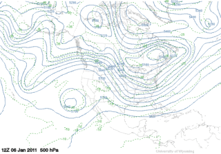 |
| Graphics courtesy U of WYO |
12 entries
1 Rookie
3 Intern forecasters
2 Journeyman forecasters
6 Senior forecasters including Chief forecaster Iralibov
Another 'true' snow storm unlike some years where we try to forecast what is little more than a narrow stripe of snow under the northern edge of a mainly rain storm's comma cloud.
---
All forecasts have been posted to the Contest's home page.
Follow the link from Storm #3.
Entries are ranked in ascending order by 'storm-total' snowfall.
Please check you entry for accuracy.


 |
| Daily Wx Map 08-JAN-11 |
The raw forecasts have been posted to the NEWx GoogleGroup.


 |
| Main Street Camden...ME 1901 |
17 entries
2 Rookies
3 Intern forecasters
1 Journeyman forecasters
11 Senior forecasters including Chief Forecaster Iralibov
Another great turn-out and a difficult storm for the season's second act.
All forecasts have been posted to the Contest's web site.
Follow the link from Storm #2.
Entries are ranked in ascending order by 'storm-total' snowfall.
Please check you entry for accuracy.
Broad range of expected storm-total snowfall...
Min: 28" (Roger Smith)
Max: 128" (albwxexaminer)
Avg: 70"
Median: 64"
STD: 23"


