Wednesday, December 31, 2014

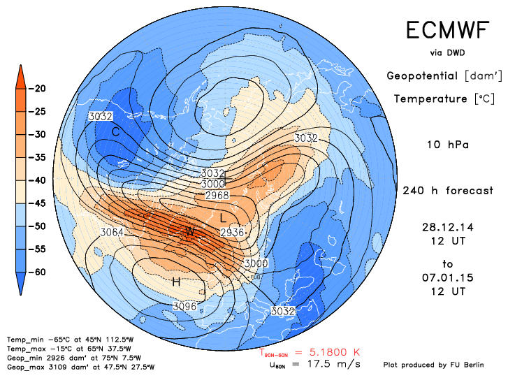
Winter '14 / '15 - Weakening Polar Vortex ==> Sudden Stratospheric Warming: UPDATE 5

"Overall, the easterly winds descending into the lower tropical stratosphere is continually favorable for redirecting tropospheric waves anomalously poleward, which increases the odds of interaction with the stratospheric polar vortex and hence increases the chances of a SSW event this winter. (AER)

OBS


CPC - Stratosphere-Troposphere Monitoring

---
First sign of sudden warming at 30 mb

30-hPa temperature change in a week in the Northern Hemisphere
The contour interval is 5 °C. The pink and light blue shadings indicate warming and cooling, respectively. The red shading denotes warming for values higher than 25 °C.
 
Tokyo Climate Center, Climate Prediction Division
 
---
PROGS
NWP projecting a return to above-normal temperatures around mid-JAN.
Have they accounted for the effects from this SSW event?

Tuesday, December 30, 2014

Winter '14 / '15 - Weakening Polar Vortex ==> Sudden Stratospheric Warming: UPDATE 4

OBS
Expanding area at 10 mb over Siberia (red shading) where the one-week temperature change exceeds 25°C.
 
10-hPa temperature change in a week in the Northern Hemisphere

The contour interval is 5 °C. The pink and light blue shadings indicate warming and cooling, respectively. The red shading denotes warming for values higher than 25 °C.
 
Imagery courtesy Tokyo Climate Center, Climate Prediction Division
 
---
PROGS
The 12z / 29-DEC-14 ECMWF suggests the 'split-vortices' SSW portion of the current event will peak between 03 / 06-JAN-15 followed by displacement. on D+10.


Deep-layer easterlies depicted on 03-JAN.
Short-lived daughter vortices appear briefly at the 475K level on 06-JAN.

Displacement
 
---
SSW TYPES 


Sunday, December 28, 2014

Winter '14 / '15 - Weakening Polar Vortex ==> Sudden Stratospheric Warming: UPDATE 3

Minor warming in progress INVOF Siberia.

 
10-hPa temperature change in a week in the Northern Hemisphere
The contour interval is 5 °C. The pink and light blue shadings indicate warming and cooling, respectively. The red shading denotes warming for values higher than 25 °C.
 
"A stratospheric warming is called 'minor' if a significant temperature increase is observed ([...] >= 25°C in a ... week or less) at any stratospheric level in any area of winter time hemisphere. The polar vortex is not broken down and the wind reversal from westerly to easterly is less extensive." (REF)
 
Imagery courtesy Tokyo Climate Center, Climate Prediction Division

Major warming appears imminent.


"Major SSWs occur when the westerly winds at 60N and 10 mb  reverse direction. A complete disruption of the polar vortex (PV) is observed.  The PV will either be split into daughter vortices ... or be displaced from its normal location over the pole." (WMO)

Friday, December 26, 2014

Winter '14 / '15 - Weakening Polar Vortex ==> Sudden Stratospheric Warming: UPDATE 2

The 12z / 25-DEC-14 run of the ECMWF continued its current campaign for a sudden stratospheric warming (SSW) event come JAN.


Progs suggest the birthing of daughter vortices around 04-JAN-15 induced by the upward propagation of a large tropospheric Rossby wave in a QBO-east environment.  A 'major' SSW event is indicated.
 
"A major SSW occurs when the 10 mb 60°N zonal mean zonal wind reverses from westerly to easterly and the 10 mb zonal mean temperature gradient increases poleward of 60°N." (.pdf)
 
Another view of the impeding split at the 475K level from a potential vorticity (NASA) perspective ... 
 
 
The downward propagation of the stratospheric easterly circulation (or a significant weakening of west wind) and the establishment of the Arctic Oscillation (AO) in its negative phase usually follows major SSW events.


Thursday, December 25, 2014

Winter '14 / '15 - Weakening Polar Vortex ==> Sudden Stratospheric Warming: UPDATE 1

The 12z / 24-DEC-14 run of the ECMWF continued its current campaign for a sudden stratospheric warming event come JAN.


Latest progs point to a weakening and splitting of the stratospheric polar vortex (PV) ... a flip in the high-latitude deep-layer tropospheric flow from W-to-E ... and the ginning-up an anti-cyclonic circulation INVOF 90°N ... all of which point to the near-term development of a negative state for the Arctic Oscillation (AO) and all that implies.

Monday, December 22, 2014

Winter '14 / '15 - Weakening Polar Vortex ==> Sudden Stratospheric Warming


Output from the ECMWF 12z / 21-DEC-14 run shown below forecasts
1)  significant weakening of the PV from 145 KT at initialization to 50 KT on the 240-hr prog and
2)  beginnings of a PV reversal (mean easterly wind above 5 mb)
3)  maintenance of a strong sub-tropical jet (STJ)


"Pronounced weakenings of the NH wintertime stratospheric polar vortex tend to be followed by episodes of anomalously low surface air temperatures and increased frequency of occurrence of extreme cold events throughout densely populated regions such as eastern North America, northern Europe, and eastern Asia that persist for ~2 months."
REF:  http://www.nwra.com/resumes/baldwin/pubs/Thompsonetal_2002.pdf

QBO/s SUPPORTING ROLE 
Winters in a negative / easterly QBO regime favor PV weakening and subsequent SSW events.  In years with low solar sunspot activity ... the polar winter vortex also tends to be disturbed and weak when the QBO is easterly; however ... solar sunspot activity is neither high nor low.

FWIW 
Top three QBO analog years are 1972 ... 1958 ... and 2009.

1972/3 - strong el Nino
1958/9 - weak el Nino
2009/10 - moderate el Nino

QBO phases typically last ~13 months before reversal.
The QBO is seven months into its east phase through NOV-14 and will remain negative throughout this winter.

Winter '58 / '59 snowfall in the southern M-A was well above normal ... central M-A and NNE much below normal ...  and SNE below normal.

OUTLOOK
The time to propagate a SSW-induced west-to-east flow reversal from 10 mb to the near-surface is variable but averages ~3 weeks.  All else equal ... should the 12z 21-DEC-14 ECMWF perfect-prog verify ... the full effects associated with a persistently negative Arctic Oscillation (AO) would not be felt at the surface until late JAN at the earliest.


Thursday, December 11, 2014

Winter '14 / '15 - November/s AO Predicts The State Of Winter/s AO

Does the sign of NOV/s Arctic Oscillation index (AO) of -0.530 have any predictive power for the sign of this winter/s AO?

The 2x2 contingency table below suggests it does.

At the 95% confidence level ... the Chi-square 'Test of Independence shows the negative sign of NOV/s AO and the AO sign for D-J-F are not independent but are related.  There/s a 2.8% probability the test indicates falsely they are not related.

Over the AO/s 64 year period-of-record ... the data shows when NOV is negative ... the winter/s AO will be also negative.

There/s also a statistically significant relationship between the negative sign of NOV/s AO and the sign of DEC/s AO.

False + ==> prediction is False
True + ==> prediction is True


 AO Contingency
p = 0.028
Nov +
Nov -
Total
D-J-F +
15
8
23
D-J-F -
15
26
41
Total
30
34
64
True +
50%
24%
False +
False +
50%
76%
True +

Tuesday, December 2, 2014

Winter '14 / '15 - 14th Annual 'Season-total' Snowfall Forecast Contest: Forecast Summary

Good to see everyone for the 14th Annual NE.Wx 'Season-total' snowfall forecast contest.
Sixteen forecasters this year.
All veterans.

---
As always, a wide range of forecasts with one lone forecaster/s season-total precipitation (STP) going under the NCDC period-of-record normal (P-O-R-N) season-total snowfall (934").

MIN STP:  866"
P-O-R-N:  934"
MAX STP:  1,546"
AVG STP:  1,175"
Median STP:  1,162"

Total number of station forecasts:  375
OVER:  307
UNDER:  67
P-O-R-N:  1


Forecasts in the table below are ranked in ascending order by sum-total snowfall for all stations.

Blue cells:  <= 25th percentile
Red cells:  >= 75th percentile
P-O-R-N is the Period of Record Normal.
CONSENSUS is the average of all forecasts.

----

No majority opinion for UNDER snows anywhere.
Unanimous opinion for OVER @ BGR .... CON ... and BOS.

Largest AVG OVER
PHL (168%)
BDR (146%)
BGR ... SBY (142%)

OVER / UNDER forecasts
RDU (9 / 7)
BDL ... BGM ... EWR (11 / 5)
ORH ... MDT ... SBY ... ORF (12 / 4)


---
These prizes for 1st place will be delivered post-paid right to the forecaster/s front door.

"The Snow Booklet" by Nolan J. Doesken and Arthur Judson
http://ccc.atmos.colostate.edu/snowbooklet.php

"Snow in America" by Bernard Mergan (hardcover)
http://artsbeat.blogs.nytimes.com/2009/03/02/snows-of-yesteryear/?_r=0

---
Everyone's forecast is available on the Contest/s web site.


Monday, December 1, 2014

Winter '14 / '15 - ENSO Takes A Second Step Toward el Niño Event

Is it el Niño or is it el Noño?

DEFINE the BEGUINE
One definition holds the Oceanic Niño Index (ONI) has to:
... met +0.5°C threshold for five straight months of a 3-month running mean.  For historical purposes warm 'episodes' are defined when the threshold is met for a minimum of 5 consecutive over-lapping seasons.
Another holds North America's operational definitions for El Niño, based on the ONI index is:        
El Niño: A phenomenon in the equatorial Pacific Ocean characterized by a positive sea surface temperature departure from normal (for the 1971-2000 base period) in the Niño 3.4 region greater than or equal in magnitude to 0.5 degrees C (0.9 degrees Fahrenheit), averaged over three consecutive months.
WHAT'S THE EVIDENCE?
The latest SST anomaly (SSTa) for ENSO Region 3.4 from NOAA's Climate Prediction Center (CPC) is +1.0°C (26-NOV-14).  This brings the 13-week (i.e., three months) moving SSTa average in ENSO Region 3.4 to 0.58°C.

Last week/s 13-week ENSO Region 3.4 moving SSTa average of 0.54°C breached the 0.5°C threshold for North America's operational definition for El Niño.  The week previous:  +0.492°C.

ENSO Region 3.4 SSTa (BLUE) and 13-week SSTa Moving AVG (ORANGE)
JAN-10 to Present
WTF?
In spite of these developments ... what's the hold-up in recognizing the beginning of el Niño 2014?  It is b/c of how a 'month' is defined?

A month starts on the 1st and ends on the 30th or 31st (piss off FEB). 
Anyone think there's a Gregorian calendar hanging over ENSO Region 3.4?

 Just b/c the ENSO Region 3.4 SSTa havn't been above the +0.5°C threshold for three consecutive calendar months doesn't mean +ENSO hasn't started.  The 13-week moving average (i.e., 3-month) ENSO Region 3.4 average SSTa exceeded the el Nino threshold during the week of 19-NOV-14.


CPC/s foot-dragger report
ENSO: Recent Evolution, Current Status and Predictions (01-DEC-14)

Winter '14 / 15 - Arctic Oscillation Analysis and Forecasts

New blog devoted to the Arctic Oscillation (AO) ... Siberian snow cover ... and more authored by Atmospheric and Environmental Research's (AER) Judah Cohen and Jason Furtado.

Cohen ... et al ... discovered the strong correlation between the areal coverage ... advancement rate of Eurasia/s OCT snow cover and the character of northern hemisphere's winter as modulated by the AO.

Snow Advancement Index (SAI)

The chart reports a correlation index (r) of 0.810 indicating the AO and SAI often move in tandem. 
Squaring the correlation index gives the 'coefficient of determination'; a measure of how much of the variability of one (DJFM AO) is explained by the other (SAI). The SAI 'explains' 66% of DJFM/s AO variability.
 
---
Cohen/s 2013 interview with the WAPO
Cohen/s 2014 interview with the WAPO
Snow cover data from Rutgers Global Snow Lab
 
 
 ---
AER offers a 'notify new post' form requiring personal contact information.
Or use the free Change Detection web page monitoring service.

Saturday, November 29, 2014

Winter '14 / '15 - Storm #1: FINAL Results

Full forecast verifications and summary for Storm #1 at the Contest/s web site.

---

     
 1st - Mitchel Volk 
 SUMSQ:71.56  
 SUMSQ Z:-1.234  
 STP:11.4 (5) 
 TAE:28.9 (1) 
 AAE:1.20 (1) 
     
 2nd - donsutherland1 
 SUMSQ:119.32  
 SUMSQ Z:-0.817  
 STP:5.0 (3) 
 TAE:43.5 (3) 
 AAE:1.81 (3) 
     
 3rd - snocat918 
 SUMSQ:128.1  
 SUMSQ Z:-0.740  
 STP:9.8 (4) 
 TAE:41.9 (2) 
 AAE:1.68 (2) 
     
 HM - Herb@MAWS 
 SUMSQ:187.5  
 SUMSQ Z:-0.221  
 STP:1.1 (1) 
 TAE:49.5 (6) 
 AAE:2.06 (6) 


---
SUMSQ: sum of square errors
STP: storm-total precipitation error
TAE: total absolute error
AAE: average absolute error
(number): category rank
Click on images for higher resolution.


Friday, November 28, 2014

Winter '14 / '15 - Storm #1: Preliminary Verification

Preliminary storm-total snowfalls for Wednesay and Thursday from CDUS41 and CXUS51 bulletins.
Good coverage and reporting.

PWM/s 6.3 SN:H20 appears to be close since there was a brief period of mixed precipitation before turning to all snow.

Nine new daily snowfall records:
WED ... 26-NOV-14
CON - 10.3" (4.5"; 1956)
ALB - 9.6" (4.9"; 1888)
BGM - 9" (8.7"; 1977)
PWM - 7.4" (7"; 1885)
ORH - 5.3" (2.9"; 1921)
ABE - 4.9" (1.7"; 1925)
BDL - 4.6" (0.4"; 1985)
IAD - 1.6" (1.1"; 1978)
ACY - 0.05" (0.05"; 1977)

Two new daily rainfall records:
WED ... 26-NOV-14
ORH - 1.79" (1.78"; 1958)
RDU - 1.69" (0.98"; 1979)


Please report any errors in Comments along with a link to the correct data.
Final results Saturday evening.

Thursday, November 27, 2014

Winter '14 / '15 - Snowiest NOV on Record in BGR

PUBLIC INFORMATION STATEMENT
NATIONAL WEATHER SERVICE CARIBOU ME
831 AM EST THU NOV 27 2014
...SNOWIEST NOVEMBER ON RECORD IN BANGOR...

A MONTHLY TOTAL OF 25.9 INCHES OF SNOW HAS BEEN OBSERVED AS OF 7 AM THIS
MORNING AT BANGOR. THIS RANKS AS THE SNOWIEST NOVEMBER ON RECORD
SURPASSING THE PREVIOUS RECORD OF 24.6 INCHES SET IN 1962.

AT CARIBOU...A TOTAL OF 26.7 INCHES OF SNOW HAS BEEN OBSERVED THIS
NOVEMBER AS OF 7 AM THIS MORNING. THIS NOW RANKS AS THE 6TH
SNOWIEST NOVEMBER ON RECORD. THE ALL-TIME SNOWIEST NOVEMBER WAS
IN 1974 WHEN A TOTAL OF 34.9 INCHES OF SNOW WAS OBSERVED.
---
Yesterday's 9.6" pushed BGR over the top.

Wednesday, November 26, 2014

Winter '14 / '15 - Storm #1: The Forecasts!

Rookies 0
Interns 0
Journeymen 1
Seniors 10
TOT 11

Total station forecasts: 245


Forecasts are ranked by their storm-total precipitation (STP).
BLUE ==> 25th percentile.
RED ==> 75th percentile.
STP cells without color are between the 25th and 75th percentile.

---


Heaviest snowfall (+6") consensus across northern New England and inland portions of the M-A.


Again ... the primary teleconnections indices associated with heavy snow in the NE US are MIA.

Everyone/s station-by-station forecast at the Contest/s web site.

Winter '14 / '15 - Storm #1: RAW Forecasts

RAW forecasts here

Monday, November 24, 2014

Winter '14 / '15 - Storm #1: Call for Forecasts!

DC's Embassy Row - Massachusetts Ave
11-NOV-38
Northern portions of NEWxSFC/s forecast area in line for an early-season contest-worthy snowfall featuring a weak Miller 'A' nor'easter.

This would be the earliest contest storm in NEWxSFC/s 16 year history beating the old record set in 2002 by one day. 

The 2002 storm dumped 9" at BDL ... 5.8" at PVD ... 4" at ORH ... and lesser amounts from PHL (T) to CAR (T).

'Call for Forecasts' e-mails will be issued this evening.

---
Forecast element: storm-total snowfall
Deadline for entries:  10:30 PM EST ... TUE ... 25-NOV-14

Verification period begins:  12:01 AM EST WED ... 26-NOV-14
Verification period ends:  11:59 PM EST THU ... 27-MAR-14

---
Enter your forecast at the NEWxSFC/s home page here.
Follow the top-of-page link from 'Enter Storm Forecast.'

Contest for Storm #1 may be cancelled prior to the deadline if fewer than six stations are likely to observe at least a 4" snowfall.

---
As always ... there/s no cost ... no fee ... no advertising ... or annoying requests for personal information to enter a forecast.  It's just a fun exercise for winter wx enthusiasts to see who can make the best synoptic-scale snowfall forecast.

---
If you are issuing your first forecast this winter...or you entered the 'season-total' forecast contest ... you/ll need to create an account (user name / password / valid e-mail ... if you want a copy of your forecast sent to your Inbox).

Sunday, November 2, 2014

Winter '14 / '15 - 14th Annual 'Season-total' Snowfall Forecast Contest - Call for Forecasts!

NE.Wx's 14th annual ‘Season-total' Snowfall Forecast Contest is the absolute best...biggest...and probably ONLY chance to be recognized for your long-range forecasting acumen.

All you have to do is forecast the season-total snowfall at 25 stations from RDU to CAR.

Deadline: SUN...30-NOV-14 @ 11:59 PM EST

Visit the Contest's website to enter your forecast.
Follow the link from 'Enter Season-total Forecast.'

1st place prize (delivered post-paid right to your front door):
"The Snow Booklet" by Nolan J. Doesken and Arthur Judson (paperback and .pdf) and
"Snow in America" by Bernard Mergan (hardcover)

As always...NO cost...NO fees...NO advertising...NO annoying requests for personal information to enter the contest.  NEWxSFC is just a fun exercise for winter wx enthusiasts to see who can make the best season-total snowfall forecast.

 ---
Forecast element:  sum-total season snowfall @ each station
Forecast period:  01-DEC-14 through 31-MAR-15
Verification:  NWS preliminary climate reports (CLM or CF6)

Error statistic:  total absolute error [Σ abs(forecast - observed)]

Update your forecast as often as you want prior to the deadline.
Only your last entry gets verified.

 ---
The reigning NE.Wx ‘Season-Total’ Snowfall Forecasting Champ-een is WXCHEMIST.
Last year's 'Season-total' forecast summary...verification...and final results ==> here.

 ---
The Contest is open to amateur and professional forecasters; broadcasters with or without trained Seals; any and all weather-biz types and / or wanna-bees; wish-casters...astrologers...along with any other universally recognized classes of dreamers; Pollyannas or Cassandras...registered Nostradamusts...non-violent megalomaniacs...woolly-bear caterpillars or their agents...pest detectives...NE.Wx NG regulars and lurkers; refugees from AmericanWx and/or USWeather...including self-imposed exiles from Eastern...and of course...meteorologists.

In honor of USENET ne.weather's patron saint Mr. Joseph Bartlo's final request (RIP)...trolls...goats...hat3-lsiters...and psests need not apply.

Sunday, July 20, 2014

Winter '14 / '15 - Outlooks

Thread updated periodically as new outlooks and forecasts are issued from a variety of sources.

---
Accu-Wx
"After record-shattering temperatures and high snow totals last winter in the Northeast, a similar theme will continue into the 2014-2015 season."


NOAA
"Last year’s winter was exceptionally cold and snowy across most of the United States, east of the Rockies. A repeat of this extreme pattern is unlikely this year"


Climate Prediction Center
(Experimental Unofficial Two-class Monthly & Seasonal Climate Outlooks)


Saturday, April 26, 2014

Winter '13 / '14 - 'Regular Season' Contest: FINAL Results

NYC
27-DEC-47
Turned out to be a fairly decent season with eight contest-worthy storms.
(DEC - 1; JAN - 2; FEB - 2; MAR - 3)

Top Forecasters ('two-thirds' rule)
1st - donsutherland
2nd - Brad Yehl
3rd - Herb @MAWS
Honorable Mention: TQ

Top Forecasters (entered all eight Contests)
1st - donsutherland
2nd - Herb @MAWS
3rd - TQ
Honorable Mention: Brad Yehl

More 'slice and dice' results at the Contest/s web site here.

Everyone's storm summary data here.

See y'all next winter!

Sunday, April 6, 2014

Winter '13 / '14 - 13th Annual 'Season-total' Snowfall Forecast Contest: FINAL Results


Full forecast verification at the Contest/s web site here.
See y'all next year!

Winter '13 / '14 - 13th Annual 'Season-total' Snowfall Forecast Contest: Forecaster STP


Table ranks Forecasters by their expected cumulative season-total snowfall (STP) compared to the cumulative observed season-total snowfall only.  It does not indicate how well the forecast verified.

Observed:  1412.7"
Period-or-Record normal (PORN):  934"

The cumulative season-total snowfall was 479" (51%) above normal.


GREEN - 75th percentile and above
RED - 25th percentile and below