Friday, December 31, 2010

Winter '10 / '11 - Coastal Teaser #2

Look familiar?

GooFuS has a coastal storm on the 7th as well; however...its genesis is in the northern stream leaving the SW bowling ball behind.


Graphics courtesty Plymouth State Wx Center.

Wednesday, December 29, 2010

Winter '10 / '11 - Snow Storm #1 - Final Results

1st
Donsutherland1
SUMSQ: 385.44
SUMSQ Z: -1.277
STP: 3.45 (1)
TAE: 81.25 (1)
AAE: 3.01 (1)

2nd
Donald Rosenfeld
SUMSQ: 526.03
SUMSQ Z: -1.033
STP: 12.85 (4)
TAE: 95.85 (3)
AAE: 3.55 (3)

3rd
Mitchel Volk
SUMSQ: 585.48
SUMSQ Z: -0.929
STP: 20.65 (5)
TAE: 97.35 (4)
AAE: 3.61 (4)

Honorable mention
EJBauers
SUMSQ: 614.01
SUMSQ Z: -0.880
STP: 51.45 (8)
TAE: 104.25 (5)
AAE: 3.86 (5)

SUMSQ: sum of square errors
STP: storm total precipitation error
TAE: total absolute error
AAE: average absolute error
(number):  category ranking

Full forecast verification and summary at the Contest web site.

Winter '10 / '11 - Snow Storm #1 - Snow Cover

Image courtesy NASA's Terra satellite.

Close-up of the NE here

Winter '10 / '11 - Snow Storm #1 - Teleconnections


Arctic and North Atlantic Oscillations have been below zero...with few exceptions...since mid-NOV thanks to strong hi-latitude blocking over the North Atlantic and Pacific Oceans.

Likewise...the PNA.

Winter '10 / '11 - Snow Storm #1 - Storm Evolution at 500 MB


Short-wave trough comes ashore in southern CA on 23-DEC-10...undercuts the short-wave ridge axis over the Rockies on the 24th...then phases with a northern stream short-wave in over the lower MS River Valley.  Note the strong cold air advection (CAA) driving the northern stream short-wave at 00z on the 26th prior to the phasing which causes the wavelength to shorten and amplify.

The mid-level circulation begins to close off 12 hours later at 12z on the 26th followed by a 12-hour 180 m height-fall between 00z and 12z on the 27th.  Large height-falls at 500 MB indicate strong cooling aloft associated with strong upward vertical motion (UVM).

Stream-phasing was one element behind the flip-flopping of NWP solutions in the run-up to the snow storm.

Graphics courtesy University of Wyoming

Tuesday, December 28, 2010

Winter '10 / '11 - Snow Storm #1 - Preliminary Verification

Preliminary storm-total snowfalls for Sunday and Monday from CDUS41...CXUS51...and PNS.

No snowfall data in the NWS climate bulletins for SBY.  Verifying storm-total snowfall is the average of two vicinity station reports from AKQPNS.  This station's snowfall reporting fell into a black hole last year and has yet to reappear.

Storm-total snowfall for CON looks suspicious given its relatively low water equivalent; however...vicinity reports carried in BOXPNS suggest the amount is accurate.

Twelve new daily records.

SUN...26-DEC-10
ISP - 11.3" (1"; 2003)
JFK - 10.5" (4.4"; 1969)
ACY - 17.4" (0.2"; 1970)
ORF - 13.4" (5"; 2004)
RDU - 6.7" (T; 2004)

MON....27-DEC-10
CAR - 6.2" (5.4"; 2005)
BGR - 10.3" (4.1"; 1947)
BOS - 8.3" (5.7"; 1894)
BDR - 4" (1.1"; 1963)
BDL - 7" (4.7"; 1944)
JFK - 5.1" (3.2"; 1984)
EWR - 6.5" (4.7"; 1984)

Please report errors and a link to the correct data in Comments.

Final results and storm summary by WED evening.

Monday, December 27, 2010

Winter '10 / '11 - Arctic Oscillation

Beautiful imagery from NASA/s Earth Observatory showing surface air temperature anomalies resulting from persistently negative Arctic Oscillation.  Red (blue) areas are warm (cold) surface air temperature anomalies.  "This image shows the temperature of the land surface for December 3-10, 2010 compared to the average temperature for the same period between 2002 and 2009."

The monthly Arctic Oscillation index has been below zero...15 out of 18 months since JUN-09.  The AO fell to an all time low of -4.266 in FEB-10.  Last winter's D-J-F average was -2.587.

Persistent HIGH pressure...often associated with a weak polar vortex (PV)...over the north pole allows arctic air to drain into low latitudes.  Daily AO values have been negative since mid-NOV.  This goes against type considering the QBO is in its westerly phase where the AO is typically positive...a consequence of a strong...cold PV.


Winter '10 / '11 - Snow Storm #1 - NYC/s NWS MET Fails Blizzard Test

From the NYT...

"But for all its bluster and powder, the monster storm was technically a blizzard only outside of Manhattan. The winds in Central Park topped out at 36 miles per hour but were not sustained over a period of three consecutive hours, nor was the visibility under a quarter of a mile for that period — both requirements to qualify as a blizzard.

“We didn’t quite make the criteria in Central Park,” said Matt Scalora, a meteorologist with the National Weather Service in Central Park. “But we did meet the criteria at J.F.K. Airport and La Guardia,” he added."
Blizzard conditions were observed at JFK but not at LGA where the SFC visibility never went below 1/4SM.

KLGA 262346Z 35024G33KT 1/4SM +SN BLSN VV001
KLGA 262351Z 35026G37KT 1/4SM +SN BLSN VV001
KLGA 270051Z 35023G38KT 1/4SM +SN BLSN VV001
KLGA 270151Z 35026G43KT 1/4SM SN BLSN VV001
KLGA 270251Z 34025G38KT 1/4SM SN BLSN VV001
KLGA 270351Z 34027G40KT 1/4SM SN BLSN VV001
KLGA 270451Z 33031G40KT 1/4SM SN BLSN VV001

Winter '10 / '11 - Snow Storm #1 - NYC-area Blizzard Conditions

03z SFC analysis
JFK and HPN (White Plains) get the brass ring.  Other surrounding stations came close but failed the three-hour restricted visibility criterion.

Blizzards are high-wind storms where falling or blowing snow severely restricts the surface visibility for a period of three hours or more.

The blizzard began at JFK at 0151z (8:51 PM EST). The hour's METAR carries 0SM which is the tower visibility. SFC visibility is reported in the remarks as 1/8SM.

The wind was at or above the 30 kt threshold before and after the visibility condition was met. Blizzard conditions prevailed for three hours until 0451z (11:51 PM EST) when the SFC visibility improved to 1/4SM.

KJFK 270051Z 36029G38KT 1/4SM SN FZFG BLSN VV002
KJFK 270151Z 34034G42KT 0SM SN FZFG BLSN VV001 SFC VIS 1/8
KJFK 270251Z 34037G49KT 0SM SN FZFG BLSN VV001 SFC VSBY 1/8
KJFK 270351Z 34035G49KT 0SM SN FZFG BLSN VV001 SFC VIS 1/8
KJFK 270451Z 33031G44KT 1/8SM SN FZFG BLSN VV004 SFC VIS 1/4
KJFK 270459Z 34029G42KT 1/8SM SN FZFG BLSN VV005 SFC VIS 1/4

Similar story at HPN...
KHPN 270056Z 34024G32KT 1/4SM SN BLSN VV002
KHPN 270156Z 34030G41KT 0SM SN BLSN VV002
KHPN 270256Z 33028G45KT 0SM +SN BLSN VV001
KHPN 270356Z 33032G44KT 0SM +SN BLSN VV001
KHPN 270456Z 33034G48KT 0SM +SN BLSN VV001
KHPN 270556Z 33028G42KT 0SM +SN BLSN VV001
KHPN 270656Z 33030G43KT 3/4SM +SN BLSN VV002

Blizzard conditions began in White Plains at 8:56 PM (0156z) and ended at 1:56 AM (0656z)...lasting two hours longer than JFK.

These was a similar storm sixty-three years ago to the day (requires free Djvu plug-in).

Winter '10 / '11 - Snow Storm #1 - Snow Melt Water

NYC/s 8th Avenue
27-DEC-47
ACY...EWR...and ORF observed not only record-setting snowfalls yesterday but also impressive snow melt water.  Not as generous as the historic 26-DEC-47 storm where 2.53" of melt water was measured in NYC from the 26" snowfall.

ACY - 1.60"
EWR - 1.23" (1.06")
ORF - 1.22"

SN:H2O
ACY - 10.9:1
EWR - 14.2:1 16.7:1
ORF - 11:1


Updated 12/29 to revise EWR data.

Sunday, December 26, 2010

Winter '10 / '11 - Snow Storm #1 - OKX - 0z SkewT-logP

Potent sounding out of OKX tonight.

The rawinsonde's initial low-level flight drifted to the SW over open waters before veering toward Newark...NJ (EWR) and continuing to the north across western New England.  EWR reported TSSN around the time of OKX's 0z balloon flight.

There's a deep...saturated moist layer between the SFC and 600 mb with 50 mb of conditional instability sitting on top.

The specific humidity in the crystal factory @700 mb is 4g/kg or more which can easily support snowfall rates over 1" / hr.  Note the excellent WAA nose @ 700 mb forced strongly by a 40 kt SE wind.

Cloud-tops located near 600 mb (~14K' AGL) where the saturated air temperature is < -15°C ==> perfect conditions for stellar dendrites!

Sounding courtesy NOAA's Storm Prediction Center

Winter '10 / '11 - Snow Storm #1 - Countdown to Blizzard Conditions

Common usage of the term 'blizzard' has come to mean excessive snowfall when in fact...a blizzard is a high-wind event (sustained wind or frequent gusts > 29 kts) that causes a reduction in surface visibility to less than 1/4 SM for at least three hours.

Blizzards are truely rare birds in the eastern CONUS where winter storms usually fail the visibility duration criterion.  One such event may be in the offing tonight...as evidenced by these early observations.

SPECI KTEB 262326Z 36020G30KT 1/16SM R06/1200V1800FT +TSSN BLSN FZFG OVC001 M05/M07 A2943 RMK AO2 PK WND 35031/2258 TSB20 OCNL LTGICCC P0001 $

METAR KJFK 270151Z 34034G42KT 0SM R04R/1600V2200FT SN FZFG BLSN VV001 M06/M07 A2921 RMK AO2 PK WND 35048/0140 SFC VIS 1/8 PRESFR SLP891 SNINCR 1/6 P0003 T10561072 $

METAR KEWR 270251Z 34025G35KT 1/8SM +SN BLSN VV001 M04/M06 A2926 RMK AO2 PK WND 35039/0221 TWR VIS 1/4 SLP909 SNINCR 3/14 P0018 60046 T10441056 58047 RVRNO $

METAR KHPN 270256Z 33028G45KT 0SM +SN BLSN VV001 M08/M11 A2918 RMK AO2 PK WND 34045/0250 SLP891 P0005 60013 T10831106 56058 $

Thunder snow (TSSN) reported at Tetterboro (KTEB)!

Winter '10 / '11 - Snow Storm #1 - The Forecasts

15 entries
3 Intern forecasters
3 Journeyman forecasters
9 Senior forecasters including Chief Forecaster Iralibov

Great turn-out and a great storm for the season opener.
All 27 stations in play making this an excellent test of synoptic-scale snowfall forecasting ability.

All forecasts have been posted to the Contest's web site. Follow the link from Winter '10 / '11 Storm Contest >  Forecasts > Storm #1.

Entries are ranked in ascending order by 'storm-total' snowfall.  Please check you entry for accuracy.

Broad range of expected storm-total snowfall...
Min: 80" (Weathermbug)
Max: 354" (Roger Smith)
Avg: 233"
Median: 254"
STD: 77"


Consensus heavy snowfall axis (+12") between PWM - BOS - PVD - ISP - JFK - EWR - BDR - BDL - ORH - CON - PWM.

Saturday, December 25, 2010

Winter '10 / '11 - Snow Storm #1 - Cyclogenesis

Off-shore waters of GA starting to churn...


Wind picking up...gettin'gusty.
Pressure falling nicely now.

Friday, December 24, 2010

Winter '10 / '11 - Snow Storm #1 - HPC Calls BS on 12z Model Runs

MODEL DIAGNOSTIC DISCUSSION
NWS HYDROMETEOROLOGICAL PREDICTION CENTER CAMP SPRINGS MD
143 PM EST FRI DEC 24 2010

VALID DEC 24/1200 UTC THRU DEC 28/0000 UTC

INITIALIZATION ERRORS IN NUMEROUS DIAGNOSTIC QUANTITIES...INCLUDING HEIGHT/VORTICITY FIELDS/RH...ARE EVIDENT IN BOTH THE 12Z NAM/GFS WITH SMALL BUT LIKELY SIGNIFICANT SHORTWAVE TROUGHS OVER SOUTH DAKOTA/NEBRASKA ALONG WITH SASKATCHEWAN/MANITOBA...WITH THESE AREAS ALSO NOT PARTICULARLY
RESOLVED OR PREDICTED WELL BY THE 00Z ECMWF.

THUS...THE SPECIFIC PREDICTIONS BY ALL DETERMINISTIC GUIDANCE ARE IN QUESTION...WITH THE RECOMMENDATION TO FOLLOW CONTINUITY...WITH THE FINAL OUTCOME MOST BELIEVED TO LIE BETWEEN THE 06Z GFS AND 00Z ECMWF...WITH ALL
ENSEMBLE GUIDANCE INCLUDING THE SREF MEAN/GEFS MEAN (EXCEPT NOT
THE 12Z VERSION)/ECMWF ENSEMBLE MEAN ALSO CONSIDERED USEFUL TO
ADDRESS THE CONTINUED UNCERTAINTY.

THIS APPROACH DISREGARDS THE SUBSTANTIALLY DEEPER AND WESTWARD SHIFT OF THE 12Z GFS REGARDING THE POWERFUL LOW TRACKING UP THE EASTERN SEABOARD...AND TO A LESSER EXTENT THE 12Z NAM WHICH LIES NEAR THE FAST EDGE OF THE GUIDANCE WITH THE DEVELOPING LOW.

Winter '10 / '11 - Snow Storm #1 - Call for Forecasts

NYC
27-DEC-47
Plenty-of-uncertainty about the eventual fate of the this weekend/s long anticipated east coast LOW and its attendant rapid cyclogenesis.  Today's 12z NAM has the yin while the 12z GooFuS is really yanging it up.

GooFuS hands the reins over to a strong 100kt digging short-wave in the northern stream SAT afternoon...a significant change from early projections where the main energy was contained in the southern stream.  Coupled-jet streak configuration noted around mid-day SUN.  Could be a notable event should the atmopsphere decide to read from this script.

Contest may be canceled prior to the deadline if NWP indicates a fizzling event.

-----
Deadline: 10:30 PM EST SAT...25-DEC-10
Forecast element: storm-total snowfall
Verification begins: 12:01 AM EST SUN...26-DEC-10
Verification ends: 11:59 PM EST MON...27-DEC-10

Enter your forecast at the Contest web site here.
Follow the link from 'Enter Storm Forecast.'

As always...there/s no cost...or fee...advertising...or annoying requests for personal information to enter. It's just a fun exercise among winter wx enthusiasts to see who can make the best synoptic-scale snowfall forecast.

If you are issuing your first forecast this year...or you entered the 'season-total' forecast contest...you/ll need to create an account (user name / password / valid e-mail...if you want a copy of your forecast sent to your Inbox).

If you want to be notified via e-mail when a 'Call for Forecasts' is issued...please let me know @ newx at newx-forecasts dot com.

Wednesday, December 22, 2010

Winter '10 / '11 - Stratospheric Warming - Another Try


Last signal failed to pan-out.  Probability a long-shot given the poor odds for warmings with QBO in its positive / west phase....except when sunspot activity is high.

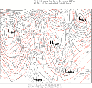
ECMWF hinting again at a break in the polar vortex (PV) last next week.

Note 1) the PV's pending split with separate circulation developing over the pole / central Russia and 2) the yellow area north-west of the Hudson Bay.  The yellow indicates warmer temperature at 100 mb which implies a very cold troposphere.  The slug of warm stratospheric air originated --- and is usually found -- over Siberia.

Winter '10 / '11 - Season-total Snowfall Forecast Contest - Forecast Summary

Individual forecasts on the Contest web site here.

Winter '10 / '11 - Coastal Teaser

Grinch appears to have stolen a white Christams for portions of the mid-Atlantic this year...which may turn out to be a good thing in the end.

Recent EC projections for a late weekend storm have been slower and stronger than GooFUS.  Today's 12z GooFUS is now coming in line with the EC solutions such that the season's 1st contest-worthy storm may be in the offing come SUN.

A 'Call for Forecasts' is possible FRI...with an entry deadline of 10:30 PM EST...SAT 25-DEC-10.

Monday, December 6, 2010

Winter '10 / '11 - Signs of A Warming Stratosphere

Extended-range progs from the ECMWF continue to suggest a warming event may be in the offing come mid-DEC...foretelling a cold start to 2011 as the bottom of the Arctic Oscillation (AO) falls out.

Note the forecast of two distinct hi-latitude cyclonic circulation centers at 100 mb...which could be in the process of ingesting the hi-amplitude tropospheric ridges positioned currently over the north Atlantic and the Bering Sea.

Thursday, December 2, 2010

Winter '10 / '11 - Season-total Snowfall Forecast Contest - Call for Forecasts


Vermont - Winter 1933
Forecast the season-total snowfall for 25 stations from RDU to CAR.

Deadline: WED...15-DEC-10 @ 11:59 PM EST

Visit the Contest's website to enter your forecast.

Follow the link from 'Enter Season-total Forecast.'

---
As always...there are NO costs...fees...or annoying requests for personal information to enter.

NE.Wx's annual ‘Season-total' Snowfall Forecast Contest is the absolute best...biggest...and probably ONLY chance to be recognized for your long-range forecasting acumen; a recognition you so richly deserve.

Not only that...but if you actually win the Contest...you get a complementary copy of "New England Weather...New England Climate" by Gregory Zielinski and Barry Keim delivered right to your front door.

What other fookin'incentive could you possibly want to enter the Contest?
How about F-R-E-E shipping?

DONE!
________________________________________________

Forecast element: sum-total season snowfall @ each station
Forecast period: 01-DEC-10 through 31-MAR-11
Verification: NWS preliminary climate reports (CLM or F6)
Error statistic: total absolute error [Σ abs(forecast - observed)]

Entry deadline: WED...15-DEC-10 @ 11:59 PM EST
________________________________________________

The reigning NE.Wx ‘Season-Total’ Snowfall Forecasting Champ-een is Herb @ MAWS.
Last year's 'Season-total' forecast summary...verification...and final results ==> here.
________________________________________________

The Contest...as always...is open to any and all of the following:
Amateur and professional forecasters; broadcasters with or without trained Seals; weather-biz types and wanna-bees; wish-casters...astro-meteorologists...and other classes of dreamers; Pollyannas or Cassandras; registered Nostradamusians; non-violent megalomaniacs; woolly-bear caterpillars or their agents; pest detectives...NE.Wx Usenet NG or GoogleGroup regulars or lurkers...refugees from EUSWx...StormVista...Golden Snowball...AmericanWx...or USWxForums...including energy sectarians and meteorologists.

Trolls...goats...hat3-lsiters...and psests need not apply.

Wednesday, December 1, 2010

Winter '10 / '11 - NEWxSFC Status

Long Island...NY 02-FEB-1934
NEWxSFC began in 1999 on USENET's ne.weather newsgroup. USENET was the only place where wx enthusiasts from far and wide could gather to monger model output...share observations...opinions...forecasts...and outlooks. Nowadays...multiple on-line forums with greatly enhanced capabilities flourish which has dispersed the population of people who might want to participate in an organized...winter-long snowfall forecasting contest but just don't know there is such a event.

Letting people know about a contest-worthy snowstorm has become a lengthy...time-consuming affair. The NEWxSFC takes a lot of time to administer...especially in the run-up to a snowstorm. Over 700 e-mail 'Call for Forecasts' announcements...sent 49 at a time every 16 minutes so as not to be flagged as spam...have gone out for prior to the late evening deadline each event. Invitations are sent to past and present Contest participants as well as weather enthusiasts in the M-A and NE. There has been a historically low response rate from these mass mailings.

'Call for Forecasts' announcements have also been made on the NEWxSFC web blog...web site...NE_WX GoogleGroup...StormVista...and at one time...The Golden Snowball. The 'Call for Forecasts'...'The Forecasts'...'Preliminary Verification'...and 'Final Results' posts on StormVista generated very few replies and a dozen or so views. Veteran NEWxSFC forecasters have made 'Call for Forecasts' announcements on other wx boards...such as EasternUSWx...with little effect. I appreciate their efforts and have been puzzled by how little interest was generated...given how much interest there is when winter wx threatens the M-A and NE.

Contest participation rates have remained steady over the years. Most events attract 8 - 15 forecasters. Most seasons see 8 - 10 forecasters eligible for ranking in the 'Final Standings.' Some veteran forecasters have understandably dropped out and few new forecasters stick around.

This winter would be Contest’s 12th season. NEWxSFC is the longest continuously held snowfall-forecasting contest on the World Wide Web. It has evolved over the years from a time when entries were harvested individually from ne.weather newsgroup and manually entered into a spreadsheet to an on-line interactive... password-protected Access database. NEWxSFC was cited in a paper delivered at the 90th Annual AMS Meeting [26th Conference on Interactive Information and Processing Systems (IIPS) for Meteorology, Oceanography, and Hydrology (http://ams.confex.com/ams/pdfpapers/164417.pdf)] JAN-10 in Atlanta…GA.

I like the way NEWxSFC has developed and matured over the years but I am no longer interested or able to run the Contest as it’s been run in the past. I had decided to the pull the plug and walk away but came to find out…I simply couldn’t do it.

---
NEWxSFC:  Winter ’10 / ‘11

Greatly scaled-back Contests will be held this winter.

There will be a 'Season-total' contest. 'Call for Forecasts' are usually made 01-NOV with a 30-NOV deadline. This year...the 'Call for Forecasts' goes out today (01-DEC) with an 11:59 PM EST 15-DEC deadline. Will likely send an e-mail announcement to last year's participants before week's end. Please hold off entering your forecast until early next week (after 12-DEC) to give me some time to do a little housekeeping and to make sure everything still works.

All past account information (User ID and passwords) for the ‘Season-total’ and ‘Regular’ season Contests will be deleted as was the practice in the past. Forecasters will need to create a separate account for each Contest. User ID and Password can be the same for each account…if so desired.

The ‘Regular’ season contest will kick off when the first contest-worthy storm presents itself.

All Contest related postings...such as 'Call for Forecasts'...'The Forecasts'...'Preliminary Verification'...and 'Final Results'...such as they are...will be made on the web log and the Contest's main web site only. 'Call for Forecasts' e-mail announcements will be sent by request only (send requests to: newx (at) newx-forecasts (dot) com).

One easy way to keep abreast of Contest status and announcements would be to subscribe to the web blog via an RSS feed.

Please feel free to spread the word in other forums and offer suggestions in Comments.

Saturday, October 16, 2010

Tuesday, March 2, 2010

Winter '09 / '10 - Interim Standings - 3

After seven contest-worthy snow storms...the third interim standings have been posted here.

Under the 'Two-thirds' Rule...forecasters who/ve made at least five forecasts were included in the Interim Standings.

Image:  Brookline...MA 1952

Sunday, February 28, 2010

Winter '09 / '10 - Snow Storm #7 - Final Results

NEWxSFC Chief forecaster donsutherland1 has won this season/s 7th snowfall forecast contest.

SUMSQ error: 132.3"
Z-score: -1.129

Improvement over the average error: 78% (595")

Lowest station errors @BTV and ABE

His forecast placed 1st in all categiories - storm-total precipitation...total absolute error...average absolute error...and R-SQ

Congratulations donsutherland1!

2nd Place: weatherT (299.1"; -0.720)
3rd Place: TQ (342.6"; -0.616)
Honorable Mention: millersville_bauers (382.4"; -0.518)

Full forecast verification...storm summary...and final results at the Contest web site.

Saturday, February 27, 2010

Winter '09 / '10 - Snow Storm #7 - Preliminary Verification

Preliminary storm-total snowfalls for Thursday and Friday from CDUS41 and METARs.

No climate or spotter reports for SBY.  METARs suggest trace amount.
Nine new daily records.

THU...25-FEB-10
BGM - 13.9" (4.2"; 1966)
ABE - 9.8" (3.2"; 1966)
ACY - 4.6" (1.6"; 1974)
EWR - 6.7" (2.4"; 2005)

FRI....26-FEB-10
BDR - 4.9" (3"; 2007)
ISP - 8.9" (2.9"; 1991)
JFK - 8.5" (6.4"; 1991)
ACY - 4.1" (2.8"; 1993)
EWR - 8.2" (4"; 1991)

Please report errors and a link to the correct data in Comments.

Final results and storm summary Sunday evening.

Friday, February 26, 2010

Winter '09 / '10 - Snow Storm #7 - The Forecasts

Forecaster Summary
Forecasts in the table below are ranked by storm total precipitation (STP) in ascending order. Blue (red) STP values are below (above) the 25th (75th) percentile of all forecast STPs.


Average STP (126.5") per average number of stations (24) forecast: 5.3".

Twelve entries...including three Rookies...one Intern...and eight senior forecasters...issued 288 station forecasts for the winter/s 7th contest snow storm.

Everyone's station forecasts have been posted on the Contest's web site.


Consensus for a heavy-snow event over SE NY and eastern PA.


Arctic Oscillation (AO) remains stuck well below zero. North Atlantic Oscillation (NAO) has climbed to near-zero. Pacific-North American (PNA) has collapsed indicating a flattening flow across NOAM.


Rapidly deepening surface LOW off the HSE heading for NY Harbor. Storm b/comes trapped below strong HIGH pressure parked over Canada/s maritime provinces.

Verification period ends 11:59 PM EST...FRI 26-FEB-10.
Preliminary storm-total snowfall amounts will be posted the evening of SAT 27-FEB-10.

Wednesday, February 24, 2010

Winter '09 / '10 - Snow Storm #7 - Raw Forecasts

Raw forecasts here.
All forecasts will be posted to the Contest/s home page and a summary on the web blog Thursday evening.

Tuesday, February 23, 2010

Winter '09 / '10 - Snow Storm #7 - Call for Forecasts

Two-day event depicted on short and medium range models resulting from cyclogenesis off the VA / NC coast and the surface LOW/s retrograding motion over NJ and eastern PA blocked from lifting-out by HIGH pressure parked over Canada's Maritime Provinces.

-----
Deadline: 10:30 PM EST WED...24-FEB-10

Forecast element: storm-total snowfall
Verification begins: 12:01 AM EST THU...25-FEB-10
Verification ends:  11:59 PM EST...FRI 26-FEB 10

Enter your forecast at the Contest web site here.
Follow the link from 'Enter Storm Forecast.'

As always...there/s no cost...or fee...or annoying requests for personal information to enter. Just a fun exercise to see who can make the best synoptic-scale snowfall forecast.

If you are issuing your first forecast this year...or you entered the 'season-total' forecast contest...you/ll need to create an account (user name / password / valid e-mail...if you want a copy of your forecast sent to your Inbox).

Image:
Newark...NJ  27-DEC-47

Winter '09 / '10 - Interim Standings - 2

After six contest-worthy snow storms...the second interim standings have been posted here.

Under the 'Two-thirds' Rule...forecasters who/ve made at least four forecasts were included in the Interim Standings.

Image:  U.S. Capitol...8-Jan-39

Friday, February 19, 2010

Winter '09 / '10 - Snow Storm #6 - Final Results

NEWxSFC Senior forecaster ilibov has won this season/s 6th snowfall forecast contest.

SUMSQ error: 126.6"
Z-score: -0.746

Improvement over the average error: 53% (268")

Perfect forecast @ISP and SBY

Lowest station errors @CAR...PWM...ISP...ACY...and SBY

Congratulations ilibov!

2nd Place: herb @ maws (151.9"; -0.612)
3rd Place: donsutherland1 (153.5"; -0.604)
Honorable Mention: Donald Rosenfeld (189.5"; -0.413)

Full forecast verification...storm summary...and final results at the Contest web site.

Thursday, February 18, 2010

Winter '09 / '10 - Snow Storm #6 - Preliminary Verification

Preliminary storm-total snowfalls for Monday through Wednesday from CDUS41 and METARs.

No new daily records.

Please report errors and a link to the correct data in Comments.
Final results and storm summary Friday evening.

Monday, February 15, 2010

Winter '09 / '10 - Interim Standings

After five contest-worthy snow storms...the first interim standings have been posted here.

Under the 'Two-thirds' Rule...forecasters who/ve made at least four forecasts were included in the Interim Standings.

Ordinarily...the first interim standings would have been posted after three storms...but the storms just kept a'comin.'

Image:  Boston...1910.

Winter '09 / '10 - Snow Storm #6 - The Forecasts

Forecaster Summary
Forecasts in the table below are ranked by storm total precipitation (STP) in ascending order. Blue (red) STP values are below (above) the 25th (75th) percentile of all forecast STPs.

Average STP (93.8") per average number of stations (25) forecast: 3.8".


Nine entries...including two Rookies... one Intern...and six Senior forecasters...issued 229 station forecasts for the winter/s 6th contest snow storm.

Everyone's station forecasts have been posted on the Contest's web site.


Consensus for a modest SNE event.


Arctic Oscillation (AO) stuck well below zero. North Atlantic Oscillation (NAO) remains more than one standard deviation below its mean in response to hi-latitude omega block in the vicinity of Iceland. Pacific-North American (PNA) about one standard deviation indicating amplified westerlies across NOAM.


Disorganized area of surface LOW over OH Valley and the mid-Atlantic.  Storm b/comes better organized with height where closed circulations begin near 700 mb and continue throughout the remainder of troposphere.

Verification period ends 11:59 PM EST...WED 17-FEB-10.
Preliminary storm-total snowfall amounts will be posted the evening of THU 18-FEB-10.

Sunday, February 14, 2010

Winter '09 / '10 - Snow Storm #6 - Raw Forecasts

Raw forecasts here.

All forecasts will be posted to the Contest web site and a summary on the web blog Monday evening.

Saturday, February 13, 2010

Winter '09 / '10 - Snow Storm #6 - Call for Forecasts

Northern stream short-wave forecast to intensify as it swings onto the east coast from the Upper Plains. Surface LOW expected to follow a familiar path through BWI and along coastal SNE where NWP models suggest it may linger in the Gulf of Maine...blocked by strong HIGH pressure over Greenland.

-----
Deadline: 10:30 PM EST SUN...14-FEB-10

Forecast element: storm-total snowfall
Verification begins: 12:01 AM EST MON...15-FEB-10
Verification ends: 11:59 PM EST WED...17-FEB-10

Enter your forecast at the Contest web site here.
Follow the link from 'Enter Storm Forecast.'

As always...there/s no cost...or fee...or annoying requests for personal information to enter. Just a fun exercise to see who can make the best synoptic-scale snowfall forecast.

If you are issuing your first forecast this year...or you entered the 'season-total' forecast contest...you/ll need to create an account (user name / password / valid e-mail...if you want a copy of your forecast sent to your Inbox).

Friday, February 12, 2010

Winter '09 / '10 - Snow Storm #5 - Final Results

NEWxSFC Chief forecaster donsutherland1 has won this season/s 5th snowfall forecast contest.

SUMSQ error:232.5"
Z-score: -0.996

Improvement over the average error:  57% (542")

Perfect forecast @JFK

Lowest station errors @JFK and ORF.

Congratulations donsutherland1!

2nd Place: wxfox51* (260.5"; -0.905)
3rd Place: weatherT (302.4"; -0.771)
Honorable Mention: Raven (312.7"; -0.737)
*Rookie

Full forecast verification...storm summary...and final results at the Contest web site.

Thursday, February 11, 2010

Winter '09 / '10 - BWI/s Historic Snowfall Season

History in the making....with several more weeks of winter left on the clock.

Baltimore / Washington International airport (BWI) has measured 79.9" of snow as of 10-FEB...the most ever observed since record-keeping began in 1883.

How unusual is it for BWI to see this much snow in one winter?

This amount of snow would be considered a statistical outlier...more than four standard deviations (4.322) above the period-of-record mean of 21.9".

It's more snow than 99.994% of all other winters.

Other notable seasons at BWI were 2002/3 (58.1")...1995/6 (62.5")...1963/4 (51.8")... and 1898 (51.1")....all of which were more that two standard deviations above the mean (more snow than 95% of all other winters).
Interesting to note...three of the largest season-total snowfalls have occurred in the last 15 years...during a time when NHEMI areal snowfall has been generally well below average...especially during summer.
How rare is this winter/s snowfall?
How often can an extreme season such as this be expected?

Since it/s never happened during the period-of-record...a statistical technique using a Gumbel distribution can be applied to determine the 'return-period' for BWI receiving this amount of snow in one winter. The distribution and return-period are calculated using the 126-year historical season-total snowfall data from LWX.


The 126-year Gumbel distribution for BWI season-total snowfall is shown above.

The calculation...based on the line's slope...intercept...and a crisp double-inverse natural log function...shows the return-period as once every 675 years! The return-period for the runner-up 'Winter of 1995/96' is only 115 years.

Image: Baltimore...MD FEB-1899 (credit:  Baltimore Sun)

Winter '09 / '10 - Snow Storm #5 - Preliminary Verification

Preliminary storm-total snowfalls for Tuesday and Wednesday from CDUS41...METARs...and PNS bulletins.

No climate report for SBY at post-time. AKQPNS carried a report of 8" from law enforcement. The snowfall total seems reasonable when plotted along with other reports from the immediate area. This value may be revised if CDUS41 or CF6 bulletins are issued before final verification.

No spotter report for HYA in BOXPNS. The 11-FEB-10 METAR at 12z carried a 7/group report of 0.78". That was reduced by 0.01" to account for a brief period of rain which fell during the verification period. Storm-total snowfall was estimated at 6.8" by applying an 8.8:1 ratio...the observed ratio at PVD.

Eleven new daily records.
TUE...09-FEB-10
PHL - 6" (5.5"; 2006)
IAD - 11.5" (2"; 1980)

WED...10-FEB-10
BDR - 4.8" (1.9"; 1967)
BGM - 4" (2.3"; 2003)
ISP - 9.2" (T; 2008)
JFK - 11.1" (2.5"; 1967)
ABE - 17.3" (4.2"; 1926)
PHL - 9.3" (8.7"; 1926)
EWR - 13.2" (2.6"; 1964)
BWI - 15.5" (9.8"; 1926)
IAD - 9.3" (0.5"; 1986)

New daily snowfall records at ABE...PHL...and BWI were established on Wednesday. The old records were set in 1926.  Storm evolution was similar for both events with decaying parent LOW over OH and secondary development / Miller 'B' forming off the Carolina coast.

Here are the surface maps from FEB 9th and 10th...1926...courtesy NOAA's Daily Wx Maps archive.


Note the parent LOW over OH and the initial evidence of secondary / Miller 'B' development off the Carolina coast on the 09-FEB chart.


The 10-FEB chart shows the coastal LOW at 40°N with a minimum central pressure below 29.20" Hg (988.8 mb). Nantucket's 8 AM pressure was reported as 29.16" Hg (987.5 mb) with a 12-hour change of 0.58" Hg (19.6 mb) and a wind speed of 52 MPH (45 KTS).


Please report errors and a link to the correct data in Comments.
Final results and storm summary Friday evening.

Tuesday, February 9, 2010

Winter '09 / '10 - Snow Storm #5 - The Forecasts

Forecaster Summary
Forecasts in the table below are ranked by storm total precipitation (STP) in ascending order. Blue (red) STP values are below (above) the 25th (75th) percentile of all forecast STPs.

Average STP (181.5") per average number of stations (24) forecast: 7.6".


21 entries...including five Rookies... one who has entered their first contest this winter...three Interns...two Journeyman...and 11 Senior forecasters...issued 509 station forecasts for the winter/s 5th contest snow storm.

Two entries were disqualified; one b/c the forecast included one station only and one was submitted well past the deadline.

Everyone's station forecasts have been posted on the Contest's web site.


Consensus for a northern mid-Atlantic and coastal SNE event.


Arctic Oscillation (AO) remains well below zero.  North Atlantic Oscillation (NAO) has dipped to more than one standard deviation below its mean in response to hi-latitude blocking in the vicinity of Iceland.  Pacific-North American (PNA) above one standard deviation indicating amplified westerlies across NOAM.


Parent LOW over OH put down light snowfall today.  Triple-point / secondary development over GA at 21z has moved to the coastal waters of South Carolina at post time.  Miller 'B' storm progged to come up the coast tonight and tomorrow...side-swiping coastal sections of the mid-Atlantic and SNE.

Verification period ends 11:59 PM EST...WED 10-FEB-10.
Preliminary storm-total snowfall amountst will be posted the evening of THU 11-FEB-10.

Monday, February 8, 2010

Winter '09 / '10 - Snow Storm #5 - Raw Forecasts

Raw forecasts here.
 
All forecasts will be posted to the Contest web site and a summary on the web blog TUE evening.

Winter '09 / '10 - Snow Storm #4 - Final Results

NEWxSFC Rookie forecaster Roger Smith has won this season/s 4th snowfall forecast contest with a SUMSQ error of 392.2"...a 55% improvement over the average SUMSQ error of 876". His Z-score was a respectable -1.218.


Roger also placed 1st in the 'average absolute error' category with an average error of 2.7" per station (24 stations forecast).
He had the lowest station errors @BOS...MDT...BWI...and ORF.


Congratulations Roger Smith!

2nd Place: catatonia  (SUMSQ error: 493.2"; Z-score: -0.964)
3rd Place:  wxfox51*  (500.5"; -0.946)
Honorable Mention: herb @ maws (521"; -0.894)

*Rookie

Full forecast verification...storm summary...and final results at the Contest web site.