Thursday, January 26, 2012

Winter '11 / '12 - VCP32 - Commiting Suicide


It's been that kinda winter for snow crows.

Monday, January 23, 2012

Winter '11 / '12 - Snow Storm #1 - Final Results

Mid-Atlantic/s warm and runny 'nose-of-doom'
herb@maws
SUMSQ:35.15
SUMSQ Z:-1.012
STP:5.80 (2)
TAE:19.60 (1)
AAE:0.82 (1)
donsutherland1
SUMSQ:39.49
SUMSQ Z:-0.900
STP:11.55 (4)
TAE:19.75 (2)
AAE:0.82 (2)
Brad Yehl
SUMSQ:45.16
SUMSQ Z:-0.752
STP:1.85 (1)
TAE:23.65 (3)
AAE:0.99 (3)
weatherT
SUMSQ:61.20
SUMSQ Z:-0.336
STP:13.29 (5)
TAE:27.49 (5)
AAE:1.15 (5)
SUMSQ: sum of square errors
STP: storm-total precipitation error
TAE: total absolute error
AAE: average absolute error
(number):  category rank

Full forecast verification and summary at the Contest/s web site.


Sunday, January 22, 2012

Winter '11 / '12 - Outlooks

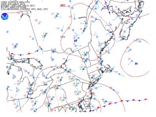
From CPC (0.5 month lead)...


La Nina continuing to hold sway over the forecast area for the last month of meteorological winter.

More winter Outlooks after the jump.

Winter '11 / '12 - Snow Storm #1 - Preliminary Verification

Preliminary storm-total snowfalls for Saturday from CDUS41...CXUS51...and PNS...as of noon Sunday.

The storm-total snowfall for HYA is an estimate derived from vicinity reports in Barnstable county carried in the PNSBOX bulletin.

Several stations in the data table do not have SN:H2O reported b/c their liquid totals included mixed precipitation.

---
Two new daily records.
Saturday...21-JAN-12
PVD - 7.6" (6.6"; 1976)
BDR - 6.2" (6"; 2001)

Please report any errors and drop a link to the correct data in Comments.

Final results and storm summary Monday evening.

Saturday, January 21, 2012

Winter '11 / '12 - Snow Storm #1 - The Forecasts

Welcome back everyone.
The kick-off event was a l-o-n-g time coming.  Here/s hoping it/s not the last!

Eight entries.
6 Senior forecasters...including NEWxSFC/s Chief forecaster donsutherland1
1 Journeyman
1 Intern

Congratulations to...
WeatherT on being promoted to Senior forecaster
Roger Smith on being promoted to Journeyman forecaster
Brad Yehl on being promoted to Intern forecaster

NEWxSFC/s Chief forecaster is the winner of last year/s 'storm-total' contest.
Senior forecasters have a minimum of three years experience.
Journeyman forecasters have two years experience.
Intern forecasters have one year experience.
Rookie forecasters are rookies.

---
All forecasts have been posted to the Contest/s web site.
Follow the 'Winter '11 / '12 Storm Contest Forecasts  Storm #1' link.

Entries are ranked by 'storm total' forecast.


Large range of expected storm-total snowfall...
Min: 30" (Roger Smith)
Max: 78" (Mitchel Volk)
Avg: 56"
Median: 54"
STD: 15"


Consensus heavy snowfall (+4") axis expected to fall inside HYA - PVD - BDR - ABE - MDT - EWR - BDL - HYA.


Little help from teleconnections.

---
Thanks to Donald Rosenfeld for hosting the Contest web site again this year.  Donald/s continued support has been instrumental in the keeping the annual NEWxSFC going for many years.

Thursday, January 19, 2012

Winter '11 / '12 - Snow Storm #1 - Call for Forecasts

c.1890
Today/s 12z progs indicating a lot of forecast stations in the mid-Atlantic and southern New England are in line to get snowed upon but there may not be all that much of it.

A weak frontal wave rising out of the OH-TN river valley early Saturday morning will throw Atlantic moisture atop an arctic air mass parked over SE Canada.

Looks to be a borderline nuisance event but at this point in a rather disappointing season...we/ll take it.


The contest may be canceled prior to the deadline if NWP indicates a fizzling event.

---
Forecast element: storm-total snowfall

Deadline for entries: 10:30 PM EST FRI...20-JAN-12

Verification period begins: 12:01 AM SAT...21-JAN-12
Verification period ends: 11:59 PM SAT...21-JAN-12

Enter your forecast at the Contest's home page here.
Follow the link from 'Enter Storm Forecast.'

---
As always...there/s no cost...or fee...or advertising...or annoying requests for personal information to enter a forecast. It's just a fun exercise among winter wx enthusiasts to see who can make the best synoptic-scale snowfall forecast.

If you are issuing your first forecast this winter...or you entered the 'season-total' forecast contest...you/ll need to create an account (user name / password / valid e-mail...if you want a copy of your forecast sent to your Inbox).

Want to be notified via e-mail when a 'Call for Forecasts' is issued?
Send your request to newx at newx-forecasts dot com.

Tuesday, January 17, 2012

Winter '11 / '12 - Season Opener?

GooFuS has been busy pumping out promising progs with shiny stellar dendrites dangling over the forecast area this weekend for what could turn out to be this winter/s season opener contest-worthy snow storm.


The storm is forecast to organize as a frontal wave over the lower MS river valley then reaches the east coast along the mid-Atlantic positioned below a weak but building arctic HIGH over the Canadian Maritime provinces late Saturday.


There's a icy cold column rich with moisture and fat bulge of WAA in the 700-800 mb layer over ALB @105hr from today/s 12z initialization.  Surface layer is an arctic air mass with temperature and dew point in the teens despite low level easterlies.

For all the talk about how critically important it is for the North Atlantic Oscillation (NAO) to be in a negative state for decent snowfalls over the forecast area...it'll be the Arctic Oscillation (AO) going negative (-1.313 @post-time) and riding to the rescue (again).

---
A 'Call for Forecasts' will be issued Thursday evening if the forecast continues its current trend.  The deadline would be Friday @10:30 PM EST.

Sunday, January 15, 2012

Winter '11 / '12 - Sudden Stratospheric Warming Watch - Update 6

The minor warming criterion (25°K increase over seven days at any level in the winter hemisphere) has almost reached the 30 mb level.  A mere two or three degrees to go.


Major warming criteria is on the verge of being breached.
A major warming is defined as "...westerly winds at 60°N and 10 mb...become easterly [...].  A complete disruption of the polar vortex is observed and the vortex will either be split into daughter vortices, or displaced from its normal location over the pole." 


Westerly winds at 85°N and above 10 mb have reversed.


'Complete' distruption is a stretch given the D+10 forecast.  There's more blue (easterly mean zonal wind) in the several panels leading up to D+10; however...the PV is also expected to re-intensify.


...but a displaced 10mb PV is carried in the forecast.


Another important indicator of stratospheric warming is E-P flux.  Apparently...when the flux vector field leans toward the pole...as shown in the analysis between 11-JAN and 13-JAN...stratospheric warming is underway.

Previous update here.

Winter '11 / '12 - Arctic Oscillation - On the Cusp

NYC - East 46th St. near 2nd Ave.
16-JAN-65
The Arctic Oscillation (AO) at winter's mid-point remains pegged in a persistently positive mode.  Save for a few brief flirtations with its alter ego...the AO has been above zero for 41 days since the start of meteorological winter (01-DEC) 46 days ago.

The polar vortex (PV) has been wicked strong until recently when it weaken slightly during the on-going minor stratospheric warming.  Minor warmings are not known for their association with PV-reversals...so there's little expectation this event will be reflected at the surface in the form of a negative AO.

What a difference a year makes.  Last December/s monthly AO was the second lowest (-2.631) during the period of record which began in 1950.  JAN-11 didn't stand out in the historical record (ranked 14th) but it was strongly negative.  This winter...December was the polar opposite at +2.221.  January is on-track to finish...not unexpectedly positive...around +1.

---
Below is a time-series of the AO on winter's cusp throughout the 60+ year period of record (1950 - 2011).  The blue line is a trace of the daily AO index on 15-JAN.  The dark red line is a a trace of the same data after applying a nine-point binomial filter.  The filter removes low frequency noise and highlights decadal trends.


Not sure what this says about the AO on 15-JAN other than there is a discernible cycle every nine years or so.  It does have an interesting comparison to the cycles found in the 30-DEC data.

Thursday, January 12, 2012

Winter '11 / '12 - North Atlantic Oscillation - About Face

NAO dips below zero for the first time in 55 days (-0.082 on 17-NOV-11).

Question now is will it last and if it does...how strong will it be?  Current GooFuS and its ensemble forecasts hold out little hope...


Arctic Oscillation (AO) forecasts are another...more promising story...


For many NEWxSFC forecast stations...a negative AO plays a bigger role than a negative NAO for contest-worthy storms.

Related posts:
Going Negative
Going Negative - How Much for Philly
Going Negative - How Much for DC?
Going Negative - How Much for Dulles?

Daily teleconnection data here.

Tuesday, January 10, 2012

Winter '11 / '12 - Sudden Stratospheric Warming Watch - Update 5

The initial minor warming event @10 mb...which began 25-DEC-11...is fading as a second warming gets underway on the opposite side of the globe (red shading lower left quadrant).


Note the weakening of the mean zonal wind in the upper 10 mb centered around 01-JAN-12 (upper right corner) which reflects dissipation of the initial minor warming event.


Elsewhere in the Ignorosphere...temperatures have been steadily warming at 30 mb over the North Pole and intersecting the long-term mean.


European NWP breaks down the polar vortex and reverses its flow @D+10 (blue shading = east flow) and depicts mean easterlies in the hi-latitude troposphere (lower right corner) which builds a deep anti-cyclone...


American NWP forecasts for the northern annular oscillations (AO / NAO) and the Pacific North American (PNA) indexes are all heading in a favorable direction...


Previous update here.

Friday, January 6, 2012

Winter '11 / '12 - Eurasia Snow Cover - December

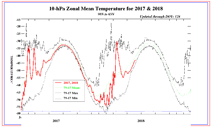
The latest monthly data from the Rutgers Snow Lab shows the observed areal snow cover over Eurasia was -- yawn -- average during December after being at or quite close to one standard deviation above the mean the past two years.

The month's ~26,642,000 km² coverage ranked 26th in the 46-year period of record (1966 - 2011) which is slightly less than the median December coverage of ~26,786,000 km².


Solid ORANGE line:  period of record's AVERAGE areal snow cover.
Dashed YELLOW lines:  + / - one standard deviation about the mean
RED line:  nine-point binomial filter

---
Snowfall data courtesy Rutgers Snow Lab.
Earlier post about Novembers' Eurasia snow cover here.

---
BONUS chart...
Monthly Eurasian snow cover for 2011 (RED line; BLUE markers) and the 'period of record' median.


Thursday, January 5, 2012

Winter '11 / '12 - Sudden Stratospheric Warming Watch - Update 4

Tervetuloa Sääbriefing!


Hi-latitude 10 mb temperature well above average.  These warm temperatures extend to near 30 mb.


NWP models continue the forecast trend for a significant weakening of the polar vortex (PV) and a bold reversal @D+10.   The blue area above 10 mb between 50°N to 90°N latitude (upper right corner) depicts a mean zonal wind flow from the east (-u:  into the board).  The orange area in the troposphere centered above 30°N latitude (lower left corner) is the strong sub-tropical jet blowing from the west (+u:  out of the board).

In the study of dynamic meteorology...the 'u' wind is the zonal component (negative for east / positive for west) of the 'total' wind.  The 'v' wind is the meridional component (positive for north / negative for south) of the 'total' wind.

If the forecast reversal of the PV is observed...the effects of this change would be felt at the surface about three weeks...which portends a very cold February.

Previous update here.

Wednesday, January 4, 2012

Winter '11 / '12 - Sudden Stratospheric Warming Watch - Update 3

The 'minor' warming event -- indicated by areas shaded in red -- having started on 25-DEC-11...has gained significant latitude as it propagated east from ~140°E longitude over Asia to a position near 80°W latitude over NOAM.


The temperature @10 mb over the North Pole has risen from -80°C in mid-DEC to almost -50°C...as of 02-JAN-12.


The lower stratosphere/s extension of the polar vortex (PV) @100 mb has split in two.  The split is forecast to upwell into the 50 mb level next week as shown in the graphic below.

The upwelling is forecast to accompany a broad...deep column of frigid air imported from Siberia into Canada's Hudson Bay region around D+10.  Of particular interest is the short-wave ridge downstream of the cold pool suggesting the feature may b/come a closed circulation.  The ECMWF 500 mb heights within this feature approach 492 dm....GooFuS ~120 meters deeper.


Finally...the PV continues to lose strength...decreasing to less than 40 kts (20 m/s) by the end of the period.  Also note 1) the mean zonal wind from the east throughout the depth of the polar troposphere...quite suggestive for a developing anti-cyclone and a long awaited return of the Arctic Oscillation to its negative state and 2) the robust 80kt (40 m/s) sub-tropical jet (STJ) INVOF 30°N latitude.


All the ingredients for severe winter weather in the eastern CONUS are forecast to come together during the start of winter's second half.

Previous update here.

Tuesday, January 3, 2012

Winter '11 / '12 - Arctic Oscillation and Chi Square

Geo. Washington...Valley Forge...PA (1928)
Wes Junker...of the WaPo/s Capital Weather Gang blog...crafted an interesting post last month about January/s temperature and precipitation prospects.  He included a rough analysis on the likelihood of December/s persistently positive Arctic Oscillation (AO) carrying over through January.  The article concluded the chances were high for such an outcome.

One measure of whether two events -- such as the AO for two months -- are independent of each other or whether a strong association exists between them is the chi-square test.  The distribution of observed events (positive one month, negative the next or vice-versa) is compared to the distribution of the 'expected' events.  Small differences between the 'observed' and 'expected' are interpreted as evidence of an association.  Large differences mean they are independent.

No statistical testing was presented in Junker/s post; however...strong evidence for an association does exist...as shown in the table below at the intersection of DEC and JAN.  The probability is 0...to three decimal places...the association between  December/s and January/s AO state occurs by chance.

---
What about the other 'cool season' months?  Can more predictive information be mined from these data?  Is there a statistically significant association between the AO state lurking elsewhere?

Monthly AO data between 1950 and 2010 from CPC were analyzed using the 'chi-square' statistic to determine if there were statistically significant associations between months.

There is a fairly strong association between SEP/s AO state and that of FEB (a 5.5% probability the association occurs by chance) and a good association between JAN and FEB (8% probability)

What does AO state for SEP-11 'predict' for FEB-12?  The SEP-11 AO was 0.665...so FEB-12 'should' follow suit and be positive.

What does AO state for JAN-12 'predict' for FEB-12?  The JAN-12 AO is unknown but since JAN follows DEC....JAN-12 AO 'should' also follow suit...which implies FEB-12 will be positive.

Winter's where the AO ran hot between DEC and FEB have occurred nine times since 1950 (1972/3...1974/5...1975/6...1988/9...1991/2...1992/3...1998/9...1999/00...2007/08).

Not lookin'good for the home-team...altho all may not be lost this winter.

The so called 'Storm of the Century' roared out of the GOM and tore up the east coast in MAR-93 after +AO in D-J-F (1.627; 3.495; 0.184) and MAR was 0.764!  There was a 'notable' NESIS storm in MAR-99 and the unforgettably infamous JAN-00 storm.

Sunday, January 1, 2012

Winter '11 / '12 - Meteorological Winter - Month One

One down.
Two to go...altho the Contest does run until the storms stop -- assuming they do get started.

As bad as it/s been for areal snow cover over the forecast area so far this winter...DEC-03 was worse with DEC-06 a close second.


December/s end-of-month snow cover between 2002 (upper left panel) and 2011 (lower right panel).  Images courtesy NOHRSC.

---
Disappointed snow crows blame the villainous duo of la Nina...which favors a storm track west of the Appalachian mountains...and the persistently positive state of the Arctic Oscillation from a paucity of hi-latitude blocking.


The above table -- sorted by descending 'percent of climo' -- shows December snowfall totals for the 'season-total' forecast contest stations.  Trace amounts are reported as 0.05.  Green (red) cells are the top (bottom) 25th percentile of values in each column.

Not a single station is even close to normal snow...altho the distribution is typical for a la Nina winter.  December's total 'normal' snowfall is 214".  The month's observed snowfall is 44", a deficit of 169" and a mere 21% of normal.