Sunday, April 15, 2007

Interim Standings


Click image to enlarge.
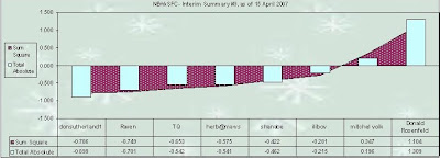
To be ranked in the latest Interim Standings...forecasters must have entered at least four forecasts to be eligible under the 'two-thirds' rule.

After five storms...
First Place: Donsutherland1 with an average SUMSQ Z-score of -0.786
Second Place: Raven -0.749
Third Place: TQ -0.653

The third interim summary finds donsutherland1 maintaining his hold on 1st place. Raven moves up a notch to second. TQ jumps from 5th to 3rd.

A data table with the complete interim standing statistics...including Sum Squared Error (SUMSQ)...Storm Total Precipitation (STP)...Total Absolute Error (TAE)...Average Absolute Error (AAE)..and R-Squared (RSQ) at the web site.

The chart shows the distribution of forecaster SUMSQ Z-Scores (plum) and Total Absolute Error Z-Scores(cyan). Lower (higher) Z-Scores indicate better (worse) forecasts compared to all other forecasts made for each storm.

A Z-Score of 0 means the forecaster's error was equal to the average of all forecast errors. A Z-Score of -1 (+1) means the forecaster's error was 1 standard deviation below (above) the average of all forecast errors.

Contest # 5 - Results


Click image to animate.

Full forecaster verification table and contest results at the web site.

Forecasters: 10
8 veterans
2 rookies

Station forecasts: 110
Average stations per forecaster: 11
Stations with observed snowfall: 11

Storm-total precipitation (STP), all stations
Forecast
Minimum: 32.5” (shanabe)
Consensus Median: 39.75”
Maximum: 65.8” (Donald Rosenfeld)

Observed: 27.35”
Max single station: 11.4” CAR
Shutout: HYA…BDR…ISP…JFK…ABE…MDT…PHL…ACY…EWR…BWI…IAD…DCA…SBY…RIC…ORF…and RDU

***************************************************
Storm #5 - Results Summary

1st Place - TQ
SUMSQ Error: 43.9”
SUMSQ - Z: -1.065
STP: 13.15 (6th)
TAE: 17.85” (1st)
AAE: 1.79” (2nd)

2nd Place - Raven
SUMSQ Error: 47.9”
SUMSQ - Z: -0.971
STP: 10.15” (4th)
TAE: 17.95” (2nd)
AAE: 1.99” (4th)

3rd Place - shanabe
SUMSQ Error: 58.0”
SUMSQ - Z: -0.734
STP: 5.2” (1st)
TAE: 20.6” (4th)
AAE: 1.72” (1st)

Honorable Mention - Mitchel Volk
SUMSQ Error: 64.0”
SUMSQ - Z: -0.596
STP: 11.65” (2nd)
TAE: 19.25” (3rd)
AAE: 3.21” (10th)

Congratulations to the Winners!

SUMSQ: sum of square errors
STP: storm total precipitation
TAE: total absolute error
AAE: average absolute error

Saturday, April 14, 2007

Contest # 6 - Canceled


Today/s NWP guidance strongly suggests too few stations are likely to get too little snowfall to warrant a forecasting contest.

Contest # 6 is canceled.

Contest # 5 - Verification


Preliminary storm-total snowfall based on final CDUS41 bulletins from Friday and Saturday.

Report any errors in 'Remarks' along with a link to the correct data. Final results and contest summary will be posted tomorrow evening.

Rank Station Snow
1 CAR 10.90
2 BGR 5.30
3 PWM 3.00
4 CON 2.60
5 BTV 2.20
8 BOS 0.05
12 HYA 0.00
8 ORH 0.05
8 PVD 0.05
12 BDR 0.00
8 BDL 0.05
7 ALB 1.25
6 BGM 1.40
12 ISP 0.00
12 JFK 0.00
12 ABE 0.00
12 MDT 0.00
12 PHL 0.00
12 ACY 0.00
12 EWR 0.00
12 BWI 0.00
12 IAD 0.00
12 DCA 0.00
12 SBY 0.00
12 RIC 0.00
12 ORF 0.00
12 RDU 0.00
TOT 26.85

PWM and CON appeared to be low; however...after comparing the reported snowfall with hourly METAR liquid reports (P/////)...they seem reasonable.

Friday, April 13, 2007

Contest # 6 - Call for Forecasts


Who/d have thought there/d be a 6th Contest storm this year…but here we are looking at a rabid…late season nor’easter with a halfway decent snowfall potential for inland stations over NNE.

Given this storm is ~48 hours away from affecting the first forecast station …there/s a possibility this event will not live up to its advance NWP billing. Saturday/s 12z model runs may force the cancellation of Contest # 6.

Entry Deadline: Saturday...14 April 2007 @ 10:30 PM EDT.

Verification begins 12:01 AM EDT Sunday...15 April 2007 and ends 11:59 PM EDT Tuesday...17 April 2007.

Your forecast must be entered via the Contest/s web site. Follow the link to ‘Enter Storm Forecast.’

All forecasts will be posted to the NE_Wx Google Group by the Contest Administrator before 11 PM EDT Saturday...14 April 2007 and to the Contest web site by Sunday afternoon.

Forecasters will need to register once before entering...even if they were registered last year. Registration is simple...requiring only a user name and password. If you provide a valid e-mail address...a copy of your forecast will be sent to you immediately after your entry is submitted. Please ensure your browser is enabled to accept first-party cookies.

Updates and announcements are posted on the Contest/s web log.

< boiler plate >

The NE.Wx Snowfall Forecast Contest (NEWxSFC) is a multi-month event that continues into late March or early April. In general...contests are held whenever a decent... synoptic-scale storm rears its head and threatens at least a half-dozen forecast stations with more than nuisance snowfall amounts. Forecasters are called to post their 'storm total' snowfall predictions...on deadline...for 27 NWS / FAA observing stations scattered about New England and the Mid-Atlantic regions.

You can find the Contest Rules and additional information about Error Scoring... current monthly snowfall climatology from NCDC...daily CPC teleconnection indices... daily NESDIS N-Hemi snow cover...and NWS Daily Climate Bulletins (CDUS41) at the NEWxSFC web site.

< /boiler plate >

Contest # 5 - Day Two Leader Board


Based on Thursday and Friday/s CDUS41 bulletins and PNS reports.

Mitchel Volk
Raven
donsutherland1
TQ
shanabe
herb@maws
weathafella
ilibov
bruced39
Donald Rosenfeld

Still snowing at CAR.

Thursday, April 12, 2007

Contest # 5 - The Forecasts


Like Contest #4...this snowfall is an interior NE event where the forecast consensus places the +SN axis from BTV - CAR - CON - ALB - BTV with a max of 7.5" at CAR.

Forecasters: 10
Rookies: 2
Veterans: 8

Minimum STP: 32.6" (Shanabe)
Maximum STP: 65.8" (Donald Rosenfeld)
Average STP: 42.7"
Median STP: 39.8"
10th percentile: 33.9"
90th percentile: 55.8"

All individual forecasts have been posted to the NEWxSFC web site. Follow the link to 'Contest # 5 - The Forecasts'. The forecasts are ranked from minimum to maximum storm total snowfall (STP) for all stations.

Verification snowfall reports will be posted Saturday morning. They are considered preliminary and subject to change / challenge for 24 hours...if updated information becomes available. Final results will be posted on Sunday.

Wednesday, April 11, 2007

Contest # 5 - Call for Forecasts


At this late date...it/s hard to believe there/s one more snowstorm still in the chamber! Winter took its good ol’ time getting here this year and by all appearances…it/s of no mind to leave.

Given this storm is about 48 hours away from affecting the first forecast station and today/s NWP solutions suggest most stations will have relatively short duration snows…there/s a possibility this event will not be a good candidate for a forecast contest. Wednesday/s 12z model runs may force the cancellation of Contest # 5.

Entry Deadline: Wednesday...11 April 2007 @ 10:30 PM EDT.

Verification begins 12:01 AM EDT Thursday...12 April 2007 and ends 11:59 PM EDT Saturday...14 April 2007.

Your forecast must be entered via the Contest/s web site. Follow the link to ‘Enter Storm Forecast.’

Forecasters will need to register once before entering...even if they were registered last year. Registration is simple...requiring only a user name and password. If you provide a valid e-mail address...a copy of your forecast will be sent to you immediately after your entry is submitted. Please ensure your browser is enabled to accept first-party cookies.

All forecasts will be posted to the NE_Wx Google Group by the Contest Administrator before 11 PM EDT Wednesday...11 April 2007 and to the Contest web site by Thursday evening.

Contest updates are posted on the Contest/s web log.

The NE.Wx Snowfall Forecast Contest (NEWxSFC) is a multi-month event that continues into late March or early April. In general...contests are held whenever a decent... synoptic-scale storm rears its head and threatens at least a half-dozen forecast stations with more than nuisance snowfall amounts. Forecasters are called to post their 'storm total' snowfall predictions...on deadline...for 27 NWS / FAA observing stations scattered about New England and the Mid-Atlantic regions.

You can find the Contest Rules and additional information about Error Scoring... current monthly snowfall climatology from NCDC...daily CPC teleconnection indices... daily NESDIS N-Hemi snow cover...and NWS Daily Climate Bulletins (CDUS41) at the contest/s web site.

Tuesday, April 10, 2007

Contest # 5 - Status


(Updated below)

Today/s 12z Eta...and its alter egos...NAM...WRF...WTF pointing toward a decent late-season contest event with about a dozen stations in play across nrn M-A and SNE. F-columns are cold aloft at cloud-top and wet wet wet in the 850-700 mb layer.

Look at the Allentown f-sounding shortly after entry deadline fer crissakes! That/s some impressive deep-layer veering and rocket-inflow in the lower levels. Even better thumping profiles to the N and E.

Had my doubts late in the weekend about whether this was another in along series of fantasy storms as the GooFuS quickly backed off its early / colder solns. Not all that different today but real wx forecasters go with the model that gives them the desired outcome...so for the time being...DaGoof is discarded.

GO / no GO decision coming Tuesday evening.

Update
Tuesday/s 12z Eta/NAM/WRF/WTF still promising a decent contest storm for Thursday over portions of NE. Several stations are no longer in the running (ABE...HYA...and PWM) but enough remain. Final GO / No GO decision awaits Wednesday/s 0z run.

Saturday, April 7, 2007

Contest # 5 - Second Chance


Today/s 12z GooFus is advertising another contest-worthy snowstorm for NNE toward week/s end. Surface chart looks similar to the one that got away a couple days ago.


Should all this come to pass according to plan...an announcement will be made Tuesday about Wednesday evening/s entry deadline.

Friday, April 6, 2007

Contest # 5 - One That Got Away


NWP solns in the run-up to the recent NNE snowfall suggested nusiance amounts and 3...maybe 4...stations would be in play but vicinity PNS reported otherwise.

ORH - 2.5"
PWM - 14"
CON - 9.5"
CAR - 9.5"
BGR - 11"
BTV - 2.8"

Too bad this late-season storm escaped notice of the progs at sufficient time-range to announce Contest #5.

There were record snowfalls to boot.

ORH - 2.3" (1.5"; '06)
PWM - 5.5" (5"; '11)
BGR - 6" (2.7"; '75), 9" (4"; '03)

Sunday, April 1, 2007

6th Annual Season-total Snowfall Forecast Contest - Results


Raven2001 finished in 1st place with a Total Absolute Error (TAE) of 143" (1.935 standard deviations [STD] below the Consensus forecast/s TAE of 457"). Raven2001/s average absolute error (AAE) of 5.7" was a 58% improvement over Period-of-Record Normal (PORN) AAE of 13.6". His seasonal forecast also ranked 1st for 'number of stations' (12 out of 25; 48%) having the lowest absolute forecast errors (CAR...BGR...PWM...CON...PVD...BDR...BDL...ACY...BWI...SBY...RIC...and RDU).

This is Raven2001/s first...first-place finish having entered previous year/s Contests in '02-'03 and '03-'04.

As this year/s top-ranked forecaster...Raven2001 is awarded "The Snow Booklet" by Nolan J. Doesken and Arthur Judson...or if he so chooses...a one-of-a-kind...hand-made...glitter-coated paper crown...expertly crafted to his exact...inflated head size by one of my two grand-daughters.


Ira Libov finished in 2nd place with a TAE of 168" (1.778 STD below Consensus) and an AAE of 6.7" (50% improvement over PORN). Ira Libov/s seasonal forecast also ranked 2nd for 'number of stations' (8; 32%) having the lowest absolute forecast errors (BOS...ORH...ALB...BGM...ABE...MDT... EWR...and ORF).

This winter is Ira Libov/s first entry in the Season-total Snowfall Forecasting Contest.


GaryM finished in 3rd place with a TAE of 230" (1.396 STD below Consensus) and an AAE of 9.2" (32% improvement over PORN). GaryM/s forecast had the lowest absolute forecast error @ DCA.


Honorable Mention goes to this season/s defending champion...Donald Rosenfeld. His TAE was 264" (1.192 STD below Consensus) and AAE was 10.5" (22% better than PORN). Donald Rosenfeld had the lowest absolute forecast error @ BGR.


Congratulations to this winter/s Top Forecasters and thanks to everyone who entered the Contest! Hope to see you all next year.

Complete Results at the web site.

Follow the link to Season-total Contest 'Results' to see this report...which includes a several data tables of summary verification statistics.

Follow the link to Season-total Contest 'Forecasts' to see the complete table of forecaster/s station verifications.