Winter '11 / '12 - Arctic Oscillation - Day 30
 |
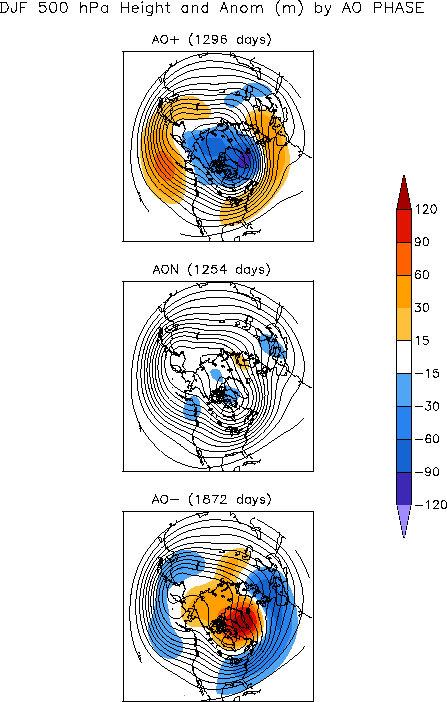
| 500 mb height anomalies associated with three states of the Arctic Oscillation |
The 500 mb height anomalies (below right) have looked more like the top chart which has kept arctic cold away from the mid-latitudes. The ECMWF continues to depict a weak anti-cyclone building over the Pole; however the on-set is always at least seven days away.
The minor stratospheric warming event @10 mb has contributed to a weakened PV but is occurring well away from the pole INVOF northeast Asia and has not propagated below 30 mb.
Minor warmings do not cause the PV to break down or cause a wind reversal from west to east so it's debatable how much influence this event will have on establishing hi-latitude blocking. Best guess: very little.
---
Below is a time-series of the AO on 30-DEC throughout the 60+ year period of record (1950 - 2011). The blue line is a trace of the daily AO index on 30-DEC. The dark red line is a a trace of the same data after applying a nine-point binomial filter. The filter removes low frequency noise and highlights decadal trends.
Not sure what this says about the AO at the end of December other than there is a decernable cycle every seven years or so.


2 comments:
Excelent my friend, very interesting, as always. Let's see how vortex evolve this january and february. Decembers with strong AO+ has been followed by January with AO+, with one exception perhaps, 1979-80.
The PV has weakened but has been reluctant to split in two...so I don't look for it to contribute much...if anything...to a sign-reversal of the AO.
You are right about DEC +AOs. When +AO in DEC...the odds favor +AO in JAN. Only a 1-in-3 chance for a -AO JAN.
Post a Comment