Saturday, January 30, 2021
Friday, January 29, 2021
Winter '20 / '21 - Snow Storm #2: Call for Forecasts!
Six long weeks after the start to NEWx/s 22nd Annual 'Snow Storm' Forecasting Contest ... Snow Storm #2 finally comes a'calling.
Amplifying mid-level flow ... shortening wavelength ... hi-latitude blocking ... Miller 'B' mid-latitude cyclogenesis ... Arctic wedge ... mixed-precipitation type issues ... and a long-duration nor'easter just like days of yore.
Even the Mid-Atlantic and a long stretch of the I-95 corridor are in play this go'round.
---
Enter your forecast at the NEWxSFC/s home page at http://www.newx-forecasts.com/
Follow the top-of-page link from 'Enter Snow Storm Forecast'
Forecast element: each station/s storm-total snowfall
Deadline for entries: 10:00 PM EST ... SAT ... 30-JAN-21
Verification begins: 12:01 AM EST ... SUN ... 31-JAN-21
Verification ends: 11:59 PM EST on the day when flakes stop accumulating.
You also get the chance to see how well your forecast stacks up against
NWS Eastern Region Weather Forecast Offices. Turns out they/ve been
fairly easy to beat!
---
If you are issuing your first
forecast this winter ... or you entered the 'season-total' forecast
contest ... you/ll need to create an account -- user name / password /
valid e-mail (if you want a copy of your forecast sent to your Inbox).
The
snowfall forecasting contest for Snow Storm #2 may be cancelled prior
to the deadline if at least six-to-eight stations are unlikely to
observe at least a 4" storm-total snowfall.
---
As always ... there/s no cost ... no fee ... no advertising ...
or annoying requests for personal information to enter a forecast. It/s
just a fun exercise for winter wx enthusiasts to see who can make the
best synoptic-scale snowfall forecast.
Thursday, January 28, 2021
Winter '20 / '21 - Coastal Teaser #2
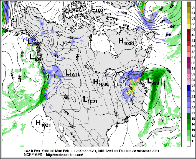
Long-duration and ginormous Miller 'B' storm complex beginning to loom large in the window as an otherwise disappointing JAN comes to a close.
Contest-worthy nor'easters have been in short supply of late so this is a welcome development.
Latest NWP guidance points toward snow beginning to accumulate over southern portions of the forecast area early SUN AM and continuing through the first few days of FEB over northern stations.
Should events unfold as advertised currently ...
Call for Forecasts: FRI ... 29-JAN-21
Deadline for entries: 10 PM EST ... SAT ... 30-JAN-21
Verification beginning: 12:01 AM EST ... SUN 31-JAN-21
Verification ending: 11:59 PM EST the day when flakes stop accumulating
Could be the start of an hyper-active period as heights progged to rise over the Pole and PNA region while AO remains below zero and the displaced PV drifts toward Greenland ...
Friday, January 15, 2021
Sunday, January 10, 2021
Winter '20 / '21 - 'Season-total' Snowfall Forecast Contest: DEC Totals
DEC-20 snowfall summary by forecast station.
Rank ordered descending by percent of monthly period-of-record-normal (P-O-R-N).
---
Green ==> 75th - 100th percentile
White ==> less than 75th and greater than 25th percentile (inter-quartile range)
Red ==> 0 - 25th percentile
---
DEC Forecast Station Highlights
15 stations above normal monthly snowfall
5 stations at least 200% of monthly normal
BGM
30" above normal
68% of its normal season-total snowfall
CON
53% of its normal season-total snowfall
ALB
47% of its normal season-total snowfall
Biggest Losers
RDU ... DCA ... ACY ... and ORF observed less than 10% of normal monthly snowfall
---
Season-Total-to-Date
DEC P-O-R-N contributes 203.3" (22%) toward the season-total snowfall (D-J-F-M) of 929".
DEC-20 observed snowfall: 292" (44% above P-O-R-N; 31% of season-total snowfall)
Image courtesy NOHRSC @ http://www.nohrsc.noaa.gov/nsa/
---
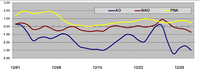
Teleconnections
Saturday, January 02, 2021
Winter '20 / '21 - Coastal Teaser #1
UPDATE: 02-JAN-21 @ 9 AM EST
Not happenin' ...
---
UPDATE: 01-JAN-21 @ 6:41 PM EST
Today/s 12z / 18z progs suggest too few stations in play for a contest-worthy snow storm.
Will evaluate 00z / 06z runs just in case ...
---
Originally posted: 31-DEC-20 @ 6:41 PM EST
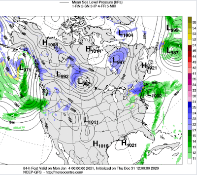
Cyclogenesis progged early this weekend in the Gulf of Mexico on the trailing end of a cold front attending FRI/s storm moving NE through the Mid-West ... Great Lakes ... and New England may turn into a long duration contest-worthy snow storm for the northern half of the forecast area come SUN.
Should the present trend in NWP output continue ...
Call for Forecasts: FRI ... 01-JAN-21
Deadline for entries: 10 PM EST ... SAT ... 02-JAN-21
Verification period: 12:01 AM EST ... SUN ... 03-JAN-21 till flakes stop accumulating
Watch this space ...
Saturday, December 19, 2020
Winter '20 / '21 - Snow Storm #1: FINAL Results
Forecaster verification table and the FINAL Results / Storm summary available at NEWxSFC/s home page.
SUMSQ: sum of square error (")
SUMSQ Z: Z-score
STP: storm total precipitation error (")
TAE: total absolute error (")
AAE: average absolute error (")
(#): category rank
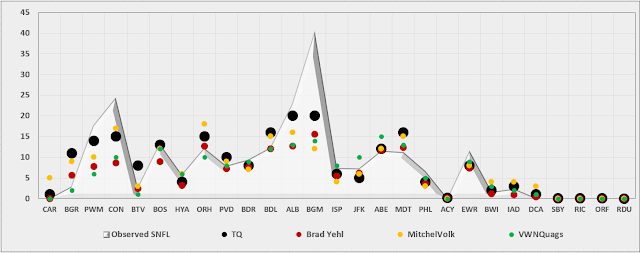
Forecast/s dotted blue line below (above) the Observed snowfall/s solid red line ==> under (over) forecast bias.
Station by Station Comparison of Top Forecasters
Friday, December 18, 2020
Winter '20 / '21 - Snow Storm #1: Preliminary STP Verification
 |
| Accumulation-weighted SN:H2O |
Preliminary verification of storm-total snowfalls for WED and THU from CDUS41 (CLI) ... CXUS51 (CF6) ... METARs ... and PNS bulletins. Excellent coverage and reporting.
HYA STP estimated by applying inverse distance weighting interpolation of five timely reports within 3 SM of the station carried by the BOSPNS bulletin.
---
SLR not reported for some stations with measurable snowfall b/c significant liquid and / or freezing precipitation also occurred during the verification period.
---
Stations observing >= 0.1" 20 (74%)
Given a station had measurable snowfall; stations observing at least ...
4" - 16 (76%)
8" - 11 (53%)
12" - 7 (33%)
18" - 3 (14%)
24" - 2 (10%)
MAX snow melt-water (minimum SLR 10:1)
BGM: 2.8"
ALB: 2.0"
BOS: 1.3"
MAX liquid precipitation (frozen + freezing + liquid):
BGM: 2.8"
ACY: 2.06"
ALB: 2.0"
---
New daily record(s)
16-DEC-20
BDR - 6.5" (2"; 1970)
ISP - 5.7" (1.5"; 1995)
JFK - 3.8" (1.3"; 1981)
17-DEC-20
BGM - 26.4" (9.8"; 1973)
CON - 24.2" (8.6"; 1970)
ALB - 19.7" (11.1"; 1970)
BOS - 12.7" (6.4"; 2013)
ORH - 10.5" (9.9"; 1970)
BDL - 7.8" (6.5"; 2016)
PVD - 6.4" (4"; 1961)
EWR - 5.9" (3"; 2016)
JFK - 3.4" (3"; 2016)
Storm total snowfall
Image courtesy NOHRSC
SFC analysis: 09z ... 17-DEC-20
Image courtesy DOC / NOAA / NWS / NCEP / WPC
---
Please report any errors in Comments along with a link to the correct data.
FINAL results expected NLT SAT evening.
Wednesday, December 16, 2020
Winter '20 / '21 - Snow Storm #1: The Forecasts!
 |
| MDT 07-FEB-67 |
Forecasters
Rookie 2
Intern 1
Journey 1
Senior 15
GOVT 1
PWSP 1
TOT 21
NEWxSFC welcomes Rookie Forecasters NJTom and Leigh Rosenthal along with our returning veterans. Congratulations to Briannavaught for her promotion to Intern Forecaster and kc2dux to Journeyman Forecaster.
Don Sutherland retains his title as Chief Forecaster this winter b/c there was only one 'contest-worthy' snow storm last winter -- minimum three storms required -- to hold a valid contest and declare a winner.
---
Forecasters ranked by ascending storm-total precipitation (STP)
BLUE ==> 25th percentile
RED ==> 75th percentile
WHITE STP cells range between the 25th and 75th percentile


