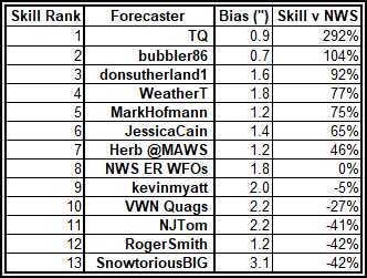
Thursday, March 02, 2023

Winter '22 / '23 - Snow Storm #2: Preliminary STP Verifications

NYC
3rd Ave (1947)
Preliminary verification of storm-total snowfalls for MON thru WED based on reporting found in CDUS41 (CLI) ... CXUS51 (CF6) ... METARs ... and PNS bulletins issued by NWS.

Excellent coverage and reporting.

HYA
1.8" derived from inverse distance weighting technique applied to vicinity reports carried by BOXPNS.

Snow-to-liquid ratio (SLR) not reported for some stations with measurable snowfall b/c significant liquid and / or freezing precipitation also occurred during the verification period.

Wednesday, March 01, 2023

Winter '22 / '23 - Snow Storm #3: Call for Forecasts!

DC
08-MAR-84
Snow storm #3 ... remnants of the recent rambunctious SoCal storm and hot on the heels of Snow Storm #2 still in progress ... heading for N-E to inaugurate the start of meteorological spring.

---
- Enter your forecast at the NEWxSFC/s home page at http://www.newx-forecasts.com/

- Follow the top-of-page link from 'Enter Snow Storm Forecast'

---
Forecast element: each station/s storm-total snowfall
Deadline for entries: 10:00 PM EST ... THU ... 02-MAR-23
Verification begins: 12:01 AM EST ... FRI ... 03-MAR-23
Verification ends: 11:59 PM EST on the day when flakes stop accumulating.

By entering ... you also get the chance to see how well your forecast stacks up against NWS Eastern Region's Weather Forecast Offices. Turns out they/ve been easy to beat!

Monday, February 27, 2023

Winter '22 / '23 - Snow Storm #2: The Forecasts!

13th and Market St.
PHL c.1930

Rookie      -
Intern      -
Journey      -
Senior      11
GOVT      1
PWSP      -
TOT      12

 Forecaster table ranked ascending by storm-total precipitation (STP)

BLUE ==> 1st quartile
RED ==> 4th quartile
WHITE and GREY STP cells range between the 1st and 4th quartile

---


Heaviest snowfall (+4") consensus along and to the right of PWM - CON - PVD - ORH - BDL - BGM - ALB - PWM.  Lollypop expected at ALB.

---
Teleconnections


---
Everyone/s station-by-station forecast at the Contest/s web site.
Direct link to the forecast table.

Sunday, February 26, 2023

Winter '22 / '23 - Snow Storm #2: RAW Forecasts

US-13 to Penny Hill
New Castle DE (1922)

 Click through on "Read more" link to see the RAW forecasts.

Saturday, February 25, 2023

Winter '22 / '23 - Snow Storm #2: Call for Forecasts!

Times Square
26-FEB-1934

SAT/s NWP suggests a late winter mid-latitude cyclone crossing the forecast area beginning late in the day on MON could produce more than nuisance snows (>= 4") over more than enough forecast stations for a contest-worthy snow storm.

---
- Enter your forecast at the NEWxSFC/s home page at http://www.newx-forecasts.com/

- Follow the top-of-page link from 'Enter Snow Storm Forecast'

---
Forecast element: each station/s storm-total snowfall

Deadline for entries: 10:00 PM EST ... SUN ... 26-FEB-23

Verification begins: 12:01 AM EST ... MON ... 27-JAN-23
Verification ends: 11:59 PM EST on the day when flakes stop accumulating.

Thursday, February 02, 2023

Winter '22 / '23 - 'Season-total' Snowfall Forecast Contest: JAN Snowfall Totals

NYC
Washington Square (1954)
JAN-23 snowfall summary by forecast station.

Rank ordered descending by percent of monthly period-of-record-normal (P-O-R-N).

Green ==> 4th quartile
White ==> less than 4th and greater than 1st quartile (inter-quartile range)
Red ==> 1st quartile

'Obs' reporting 0.05 denote 'Trace' amounts (observed but not measurable)

---
JAN Forecast Station Highlights
5 stations at or above normal monthly snowfall.
CAR ... CON ... BGR ... PWM ... BTV

Biggest Losers
16 stations with less then half their normal monthly snowfall.
ORF got skunked.

---
Season-Total-to-Date
JAN  P-O-R-N contributes 279" (30%) toward the season-total snowfall (D-J-F-M) of 934".
JAN-23 observed snowfall:  191" (68% of monthly P-O-R-N; 20% of season-total snowfall)

Images courtesy NOHRSC @ http://www.nohrsc.noaa.gov/nsa/

---
Teleconnections

AO / NAO / PNA data
https://www.cpc.ncep.noaa.gov/products/precip/CWlink/pna/ norm.daily.ao.nao.pna.aao.gdas.120days.csv

---
DEC snowfall totals:
http://newxsfc.blogspot.com/2023/01/winter-22-23-season-total-snowfall.html

Saturday, January 28, 2023

Winter '22 / '23 - Snow Storm #1: FINAL Results and Storm Summary

Richmond ... VA
Broad St (uphill from Shockoe Bottom)
Presidents Day 18-FEB-79

Complete forecaster verification table and the FINAL Results / Storm Summary available at NEWxSFC/s home page.

SUMSQ:  sum of square error (")
SUMSQ Z:  Z-score
STP:  storm total precipitation error (")
TAE:  total absolute error (")
AAE:  average absolute error (")
(#):  category rank

---
Forecast by Observed Snowfall Scatterplots for Top 4 Forecasts

Forecast/s dotted blue line below (above) the Observed snowfall/s solid red line ==> under (over) forecast bias.

---
Comparison of Top 4 Forecasts and Observed Snowfall by Station

---
Forecast Skill Score (measured against NWS ER WFOs)


Positive skill values indicate a forecast/s improvement over the NWS forecasts.

Bias is the arithmetic difference between the average Forecast snowfall and the average Observed snowfall (avgForecast - avgObserved).

Friday, January 27, 2023

Winter '22 / '23 - Snow Storm #1: Preliminary STP Verifications

NYC
East 88th St. (1952)

Preliminary verification of storm-total snowfalls for WED and THU based on reporting found in CDUS41 (CLI) ... CXUS51 (CF6) ... METARs ... and PNS bulletins issued by NWS.

Excellent coverage and reporting.

HYA
Trace amounts derived from METARs.

---
Snow-to-liquid ratio (SLR) not reported for some stations with measurable snowfall b/c liquid and / or freezing precipitation also occurred during the verification period.


---
Stations observing >= Trace:  19 (70%)
Given stations had measurable snowfall ... stations observing at least:
4" - 2 (7%)

MAX snow melt-water (minimum SLR 8:1)
CAR - 1.05"
BTV - 0.54"
BGM - 0.30"

MAX precipitation (frozen + freezing + liquid)
PWM - 2.60"
PVD - 1.84"
ACY - 1.58"

---
New daily snowfall record(s)
none

Orange cells indicate new daily record.
Trace amounts (displayed 0.05") are not included in STP.

Distribution of storm-total snowfall
Image courtesy NOHRSC

---

SFC analysis:  09z ... 26-JAN-23
Image courtesy DOC / NOAA / NWS / NCEP / WPC

---
Please report any errors in Comments along with a link to the correct data.
FINAL results expected NLT SAT evening.  

Wednesday, January 25, 2023

Winter '22 / '23 - Snow Storm #1: The Forecasts!

NYC
43rd St and Broadway (1937)

Rookie      -
Intern      1
Journey      1
Senior      10
GOVT      1
PWSP      -
TOT      13

Forecaster table ranked ascending by storm-total precipitation (STP)

BLUE ==> 1st quartile
RED ==> 4th quartile
WHITE and GREY STP cells range between the 1st and 4th quartile

---

Heaviest snowfall (+4") consensus along and to the right of CAR - BGR - CON - BGM - BTV - CAR.  Lollypop expected at CAR.

---
Teleconnections


---
Everyone/s station-by-station forecast at the Contest/s web site.
Direct link to the forecast table.

Tuesday, January 24, 2023

Winter '22 / '23 - Snow Storm #1: RAW Forecasts

PHL
Broad Street (1899)
Published in order of receipt.