Friday, February 14, 2025
Thursday, February 13, 2025
Winter '24 / '25 - Snow Storm #4: Call for Forecasts!
| Beacon St. Boston ... MA (FEB-1901) |
- Enter your forecast from NEWxSFC/s home page at http://www.newx-forecasts.com/
- Follow the top-of-page link from 'Enter Snow Storm Forecast'
---
Forecast element: each station/s storm-total snowfall
Deadline for entries: 10 PM ET FRI ... 14-FEB-25
Verification period BEGINS: 12:01 AM ET SAT ... 15-FEB-25
Verification period ENDS: 11:59 PM ET the day snow stops accumulating
The forecasting contest for Snow Storm #4 may be cancelled prior to the deadline if at least 6
to 8 stations are unlikely to observe at least 4" of storm-total snowfall.
By
entering ... you also get the chance to see how well your forecast
stacks up against NWS Eastern Region's Weather Forecast Offices. Turns
out they/ve been easy to beat!
Wednesday, February 12, 2025
Winter '24 / '25 - 26th Annual 'Regular Season' Snowfall Forecast Contest: Interim Standings #1
 |
| DC 20-MAR-1924 |
After 3 contest-worthy snow storms ... under the ‘two-thirds’ rule … forecasters who have entered at least 2 forecasts are included in Interim Standings #1.

Complete interim statistics tables and a chart at the Contest/s web site (direct link)
Forecaster statistics for Winter '24 / '25 contest snow storms (direct link)
---
SUMSQ errors for each Contest snow storm are normalized / standardized) by computing a 'Z-score'
... then averaged ... and ranked to compute the standings.
If a forecaster has issued
forecasts for more than two-thirds of all snow storm contests ... then
Z-scores from their 'best two-thirds' forecasts are used to calculate
the Interim and Final standings.
Tuesday, February 11, 2025
Winter '24 / '25 - Snow Storm #3: FINAL Results and Storm Summary
 |
| 14.3" DC (07-FEB-36) |

SUMSQ: sum of square errors (")
SUMSQ Z: Z-score
STP: storm total precipitation error (")
TAE: total absolute error (")
AAE: average absolute error (")
(#): category rank
---
Forecast by Observed Snowfall Scatterplots for Top 4 Forecasts
Forecast/s dotted BLUE line below (above) the Observed snowfall/s solid RED line ==> under (over) forecast error.
R^2: how well the forecast model 'explained' the variability of the observed snowfall (i.e., an R^2 of 0.710 means the forecast model explained 71% of the observed snowfall's variability).
---
Comparison of Top 4 Forecasts and Observed Snowfall by Station
Forecast Skill Score (measured against NWS ER WFOs)
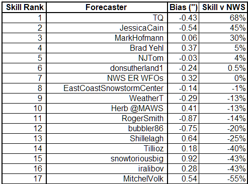
compared to NWS forecasts.
Bias: the arithmetic difference between the average Forecast snowfall and the average Observed snowfall (avgForecast - avgObserved).
Monday, February 10, 2025
Winter '24 / '25 - Snow Storm #3: Preliminary STP Verifications
 |
| Knickerbocker storm DC (28-JAN-1922) |
Good coverage and reporting.
---
HYA
STP derived from inverse distance-weighting technique using vicinity STP reports from Barnstable county carried in the BOXPNS bulletin as inputs.
Summary SLR value is quantity-weighted.
Stations with SLR < 8 are not reported b/c of probable contamination from liquid and/or freezing precipitation.
---
Stations observing >= Trace: 25 (93%)
Stations observing > Trace: 18 (67%)
Given a station had measurable snowfall; stations observing at least:
4" - 10 (37%)
6" - 1 (4%)
8" - 1 (4%)
10" - 1 (4%)
MAX snow melt-water (minimum SLR 8:1)
BDR - 0.58'
ORH - 0.51"
PVD - 0.46"
MAX precipitation (frozen + freezing + liquid)
JFK - 0.72"
JFK - 0.69"
EWR - 0.64"
---
New daily snowfall record(s)
None
---
Daily snowfall data table
ORANGE: new daily record
GREY: STP derived from PNS or METARs or inverse distance weighting
Trace amounts (displayed as 0.05") are not included in STP or SLR calculations.
---
Areal distribution of storm-total snowfall 
https://www.nohrsc.noaa.gov/
---
SFC analysis: 06z ... 09-FEB-25

https://www.wpc.ncep.noaa.gov/html/avnsfc.shtml
---
Please report any errors in Comments along with a link to the correct data.
FINAL results expected NLT TUE evening on or about 9 PM ET.
Sunday, February 09, 2025
Winter '24 / '25 - Snow Storm #4: Call for Forecasts!
 |
| Dutch Reformed / Bay Ridge Church 2nd Ave Ridge Blvd 80th St Brooklyn ... NYC (c.1900) |
UPDATE: 1:30 PM ET MON ... 10-FEB-25
THIS 'CALL FOR FORECASTS' FOR SNOW STORM #4 HAS BEEN CANCELLED.
TOO FEW STATIONS IN PLAY FOR A CONTEST-WORTHY SNOW STORM.
Contest Status
 |
| PHL - Broad and Chestnut early 1930s |
Winter '24 / '25
NE.Wx Snowfall Forecast Contests
NE.Wx Snowfall Forecast Contests
26th Annual 'Snow Storm' Snowfall Forecast Contest
UPDATE: 8:15 PM ET - TUE ... 18-FEB-25
Snow Storm #5
Synoptiscope in VCP32
Synoptiscope in VCP32
Snow Storm #4: 15-FEB-25
FINAL Results and Storm Summary here
Snow Storm #3: 08-FEB-25
FINAL Results and Storm Summary here
Snow Storm #2: 19-JAN-25
FINAL Results and Storm Summary here
Snow Storm #1: 05-JAN-25
FINAL Results and Storm Summary here
FINAL Results and Storm Summary here
---
Deadline for entries: 10 PM ET. Typically ~24 hours before the leading edge of a contest-worthy snow storm is predicted to enter the forecast area.
Enter your forecast here.
---
24th Annual 'Season-total' Snowfall Forecast Contest
UPDATE: 4:30 PM ET - FRI ... 14-MAR-25
Deadline for entries has passed.
Details and Forecasts here
Details and Forecasts here
Monthly snowfall totals
DEC here
MAR here
---
Winter '23 / '24 - Snowfall Forecast Contests
25th Annual 'Snow Storm' Snowfall Forecast ContestFINAL results here
Saturday, February 08, 2025
Winter '24 / '25 - Snow Storm #3: The Forecasts!
 |
| 4th Ave NYC (c.1908) |
Everyone/s station-by-station forecast on the Contest/s web site. NOTE: Some forecasts for 'Trace' (0.05) display as 0.1 but are recorded in the database as 0.05.
Direct link to the forecast table.
---
Rookie -
Intern -
Journey 1
Senior 14
Chief 1
GOVT 1
PWSP -
TOT 17
Forecaster table ranked ascending by the forecast storm-total precipitation (STP)
RED ==> 4th quartile
WHITE and GREY STP cells range between the 1st and 4th quartile
---

Heaviest snowfall (+6") forecast consensus along and to the right of BOS - PVD - BDL - ALB - ORH - BOS. Lollypop expected at ORH.
---
Teleconnections

Everyone/s station-by-station forecast at the Contest/s web site.
Direct link to the forecast table.
Thursday, February 06, 2025
Winter '24 / '25 - Snow Storm #3: Call for Forecasts!
 |
| Grand Army Plaza Brooklyn ... NY (FEB-1929) |
- Enter your forecast from NEWxSFC/s home page at http://www.newx-forecasts.com/
- Follow the top-of-page link from 'Enter Snow Storm Forecast'
---
Forecast element: each station/s storm-total snowfall
Deadline for entries: 10 PM ET FRI ... 07-FEB-25
Verification period BEGINS: 12:01 AM ET SAT ... 08-FEB-25
Verification period ENDS: 11:59 PM ET the day snow stops accumulating
The forecasting contest for Snow Storm #3 may be cancelled prior to the deadline if at least 6
to 8 stations are unlikely to observe at least 4" of storm-total snowfall.
By entering ... you also get the chance to see how well your forecast stacks up against NWS Eastern Region's Weather Forecast Offices. Turns out they/ve been easy to beat!
Subscribe to:
Posts (Atom)


