Saturday, January 03, 2009

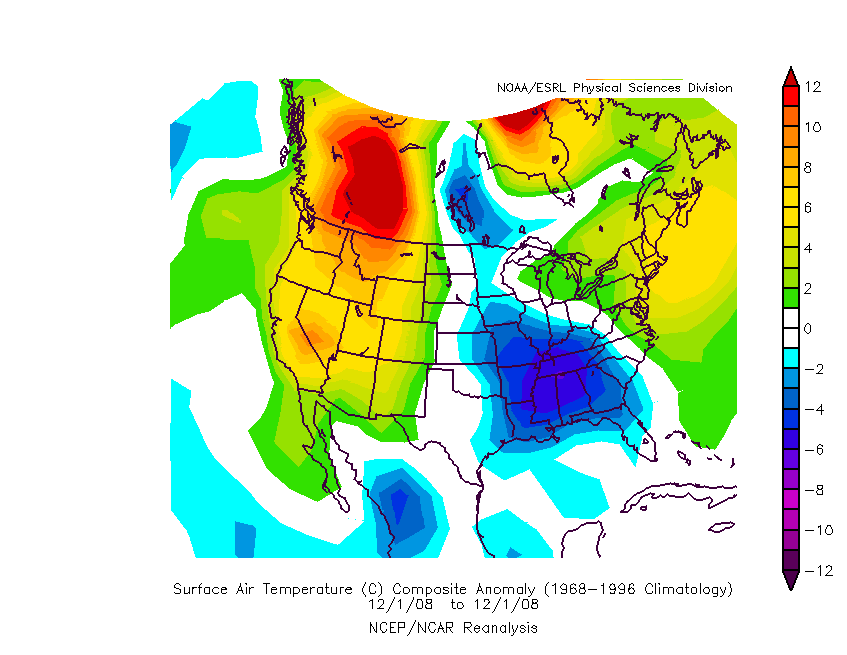
NOAM Temperature Departures - December '08

A notably...nay brutally...cold December was heralded for the eastern CONUS by many well-known LR wx forecasters as meteorological winter approached.

Offered for your consideration...a cumulative temperature departure animation for NOAM here.

Northeastern CONUS temperatures never did observe negative anomalies...nor did the mid-Atlantic region except for a brief period centered around the 8th. The negative anomaly centroid was over the SE for much of the month before retrograding into the upper Plains.

End-of-month snapshot of precipitation departures.


Note main storm track running NE through MO - IL - MI and secondary axis from MS - TN - WV continuing into New England.

The primary storm track is at odds with the statistical correlation between 'NAO - precipitation.' The map below indicates when NAO is positive the storm track runs from MO - IL - MI...as observed during December. Problem is...the daily average NAO for December was -0.281.


The ten-year NAO precipitation correlation time period was selected b/c it excludes the +PDO / +ENSO years that dominated the late 80s and early 90s. The correlation coefficient must be at least +/- 0.6 to be statistically significant.

Miller B


More...

Thursday, January 01, 2009

Snowfall Summary - December '08

December/s storm track was quite favorable for southern New England stations where Bridgeport (BDR) and Boston (BOS) observed more than triple their normal monthly snowfall.

Four other stations (Providence...Bangor... Worcester...and Burlington) measured at least twice their long-term average.

December snowfall at five stations was more than 50% of their normal season-total (D-J-F-M) snowfall.

Biggest losers were in the mid-Atlantic region...as was the case last season.

Green => Top 25%
Red => Bottom 25%

Wednesday, December 31, 2008

New Year/s Eve Snow Storm

(updated below)

Snowfall was fairly intense there for a while this afternoon...with some northeastern stations reporting rates up to 2" / hour.

At times...VSBYs went below 0.25 SM beneath 100' ceilings. Network warning radars observed widespread banding signatures south of the mid-level deformation zone.

Cold columns and an energetic short wave made for extremely high SN:H2O (ALB @ 46:1...BGM @ 31:1...and BDR @ 17:1).

Turned out to be a marginal contest storm with the majority of stations reporting little more than nuisance amounts...although spotter reports from MA and NH were notably greater. Map shows preliminary snowfall reports from CDUS41 and PNS bulletins at post time.

UPDATE:
ALB - 7.2"; 55:1
BOS - 6.5"; 16:1
ORH - 6.4"; 16:1
BDL - 4.9"; 16:1
CON - 3.8"; 17:1
PVD - 4.9"; 19:1
CON - 3.8"; 17:1

New daily records @ BDL...BDR...BOS...ORH...and PVD.

In hindsight...this storm was probably contest-worthy.

Thursday, December 25, 2008

Interim Standings

After three snow storms...Emoran holds a slim 0.027 margin over donsutherland1 with dmcguriman in third.

Under the ‘two-thirds’ rule…forecasters who have entered at least two forecasts are included in this interim summary.

Full forecaster statistics table and charts here.

SUMSQ errors for each contest snow storm are normalized with a 'Z-score'...then averaged to compute the standings. Forecasters who have entered at least 2/3 of all snow storm contests are included in the standings.

If a forecaster has participated in more than two-thirds of all snow storm contests...then Z-scores from their 'best two-thirds' forecasts are used to calculate Interim and Final standings. Same idea as dropping the lowest quiz score before the final grade is computed.

Wednesday, December 24, 2008

Snow Storm #3: Results

Senior forecaster emoran made the best synoptic-scale forecast for NEWxSFC/s third snow storm. His forecast verified with 79.2 SUMSQ error points (Z-Score = -1.013).

He completed the trifecta with lowest Total Absolute Error (25.45") and Average Absolute Error (1.21"). His 90.2% R-SQ score...a measure of how well a forecast captures the variability of the observed snowfall... was also ranked first.

Emoran had the lowest station errors @ CAR BTV BDL MDT PHL BWI and made perfect forecasts @ BDL PHL BWI.

Congratulations emoran!

Emoran wins one FREE month of StormVista GOLD for his efforts.

2nd Place: donsutherland1 (90.8"; -0.880)
3rd Place: Raven (101.5"; -0.758)

Three forecasters came within 5% of the 97.7" " storm-total snowfall.

Full forecast verification and results summary here.

Tuesday, December 23, 2008

Snow Storm #3 - Coastal Frontogenesis


Click image to animate.

Note the sharp temperature gradient between PWM and Buoy 44005. The buoy is located 78 NM east of PWM.


Rapid deepening of -2.7 mb / hr at 00z concurrent with strongest horizontal temperature gradient of 0.372°F / NM. Strong temperature gradients initiate ageostrophic circulations across the boundary leading to pressure falls and upward vertical motion.

PWM observed a record 14.5" snowfall from this storm. The old record of 12.4" was set in 1933. Snow totals are often suppressed at PWM b/c of its proximity to the coast; however...in this case...the station remained on the cold side of the coastal front and all precipitation fell as snow.

WSI - DEC Update - Winter '08 / '09

From Reuters UK...
""Most of the East should be quite mild in January, before the pattern shifts again in February and March to allow for below-normal temperatures to return to the Northeast," WSI forecaster Todd Crawford said.

"Although February and March are expected to be colder than normal on average, the Northeast will experience greater temperature fluctuations than other regions, WSI said.

[...]

""Current oceanic and atmospheric indicators are quite similar to those observed during the winters of the early 1960s, when cold western U.S. winters were commonplace," Crawford said."
NE CONUS (relative to normal)
JAN - warmer
FEB - colder (except NJ/DE/MD)
MAR - colder

Snow Storm #3: Preliminary Verification

Preliminary storm-total snowfalls from CDUS41...PNS...and CF6 bulletins for Sunday and Monday.

Seven new daily records were set on Sunday.
PWM - 14.5" (12.4"; '33)
CON - 10" (7.9"; '14)
BGR - 9.7" (7"; '95)
BTV - 9.1" (7.8"; '10)
ORH - 8" (6"; '54)
ALB - 6.6" (5.7"; 1887)
BDL - 5" (2.6"; '75)

SN:H2O @ PWM and CON estimates derived from METAR 6///// and P///// groups.

Please report errors in Remarks.
Final results and storm summary Wednesday.

Monday, December 22, 2008

Snow Storm #2: Results


Journeyman forecaster Bruced39 made the best synoptic-scale forecast for NEWxSFC/s second snow storm. His forecast verified with 112.6 SUMSQ error points (Z-Score = -1.318). His 81.3% R-SQ score was also ranked first.

Bruced39 had the lowest station errors @ PWM BTV PVD BDR.

Congratulations bruced39!

Bruced39 wins one FREE month of StormVista GOLD for his efforts.

2nd Place: donsutherland1 (123.9"; -1.199)
3rd Place: emoran (125.9"; -1.179)

Five forecasters came within 5% of the 119.85" storm-total snowfall. Not only does the forecast need to get the storm-total snowfall right...but it has to be put in all the right places.

Intern / Rookie class: First-time forecaster Anthony placed first.

Full forecast verification and results summary here.