Monday, January 26, 2009

Snow Storm #7: Raw Forecasts

Here.

13 entries...including 11 veterans and 2 rookies.

Formatted forecasts will be available at the Contest web site early tomorrow evening.

Overview and some summary charts will go up on the web blog around the same time...too.

WSI - JAN Update - Winter '08 / '09


NE...
Feb - colder than normal
March - colder than normal
April - colder than normal

""The general pattern of cold-north and warm-south observed during the winter so far will generally continue into early spring. The warmest temperatures, relative to normal, will be in the south-central and southeastern states while the coldest temperatures will continue to be observed in the north-central states.

"The cold Pacific Ocean suggests that the upcoming aggregate three-month period will be relatively cold nationwide, relative to normal, especially in March and April.

"An incipient stratospheric warming event, which appears to be historic in magnitude, may continue to favor more Arctic air masses in mid-latitudes and increases confidence in the widespread cold forecast of the US these upcoming few months.""

(updated to include full forecast discussion)

Full press release here.

Sunday, January 25, 2009

Snow Storm #7: Call for Forecasts


Large-scale...two-day event expected over the forecast area on Tuesday and Wednesday as the long-wave trof currently over the west coast comes east.

HPC discounted today/s 12z solutions for widespread heavy snow from GooFuS as an outlier; however...long-range NWP models have been flip-flopping for days on the evolution of the western trof...so here/s hoping they/ve missed the boat.

Deadline: 10:30 PM EST Monday...26 January 2009

Forecast element: storm-total snowfall
Verification begins: 12:01 AM EST Tuesday...27 January 2009
Verification ends: 11:59 PM EST Wednesday...28 January 2009

Enter your forecast here.
Follow the link from 'Enter Storm Forecast.'

Make the best forecast and you/ll win one month of FREE access to StormVista GOLD.
Details here.

More prizes will be awarded at the end of winter for the best over-all forecaster.
Details here.

As always...there/s no cost...or fee...or annoying requests for personal information to enter.

If you are making your first forecast this year or you entered the 'season-total' forecast contest...you/ll need to create an account (user name / password / valid e-mail...if you want a copy of your forecast sent to your Inbox) before entering a forecast.

Image: Niagra Falls 2/9/1908

Thursday, January 22, 2009

Sudden Stratospheric Warming

Welcome to our visitors from The Wx Outlook - TWO Community Wx Forum...NetWx...and UKWxWorld. Good discussions and information about this unusual event.

(updated below)

240-hr ECMWF: complete disruption / reversal of the polar vortex ==> MAJOR stratospheric warming.


Major winter stratospheric warmings preferentially occur during the easterly phase of the QBO (Holton and Tan (1980))...so this event is notable since QBO is currently west ~10 m/sec...as seen on the latitide-height x-section in the 30 - 50 mb layer over the Equator.


As would be expected...AO tanks...too.


All a consequence of the huge mid-month +PNA / Rossby wave propagating into the ignore-o-sphere?


Sig wx ahead?

UPDATE

Chart below shows just how unusual SSW is during QBO-west and solar minima.


(h/t TWO Community Weather Forum from across the pond)

Tropospheric after-effects of SSW lag by ~4 weeks and can last for many weeks afterward. A warm stratosphere means the tropopause has lowered which in turn means lower heights in the troposphere and low trope heights mean cold conditions at the surface.

"Pronounced weakenings of the NH wintertime stratospheric polar vortex tend to be followed by episodes of anomalously low surface air temperatures and increased frequency of occurrence of extreme cold events throughout densely populated regions such as eastern North America, northern Europe, and eastern Asia that persist for ~2 months." (Thompson et. al. - 2002)

EDIT: corrected reference to present QBO phase.

Wednesday, January 21, 2009

Interim Standings

Plenty-o-new faces in the latest Interim Summary with four more forecasters eligible for ranking.

After six snow storms... donsutherland1 retains his lead... anthony appears out of nowhere into second...a mere 0.0004 points ahead of shanabe...who slips to third.

Under the ‘two-thirds’ rule…forecasters who have entered at least four forecasts are included in this interim summary.

Full interim forecaster error statistics table and charts here.

Forecaster storm summary data here.

SUMSQ errors for each contest snow storm are normalized with a 'Z-score'...then averaged to compute the standings. Forecasters who have entered at least 2/3 of all snow storm contests are included in the standings.

If a forecaster has participated in more than two-thirds of all snow storm contests...then Z-scores from two-thirds of their best forecasts are used to calculate Interim and Final standings. Same idea as dropping the lowest quiz score before the final grade is computed.

Previous Interim summary here.

Tuesday, January 20, 2009

Snow Storm #6: Results

Senior forecaster Donald Rosenfeld made the best synoptic-scale forecast for NEWxSFC/s sixth snow storm. His 24 station forecasts verified with 84 SUMSQ error points (Z-Score = -1.285)...which was a 54% improvement over the average error of 183".

He placed first in all other forecast skill categories...as well.
Total Absolute Error: 32.15" (27% better than average)
Average Absolute Error: 1.34" (31% better than average)
STP: 14.35" (54% better than average)
R-SQ: 78% (24% better than average)

Donald Rosenfeld/s forecast had the lowest station errors @ CAR ISP SBY ORF.

Congratulations Donald Rosenfeld!

Donald Rosenfeld wins one FREE month of StormVista GOLD for his forecasting acumen.

2nd Place: Raven (117.9"; -0.846)
3rd Place: Newa (122.2"; -0.791)
Honorable Mention: Mitchel Volk (123.4"; -0.774)

Full forecast verification and results summary here.

Monday, January 19, 2009

Snow Storm #6: Preliminary Verification

(updated below - Update II - Update III)

Preliminary storm-total snowfalls from CDUS41...PNS...and CF6 bulletins for Sunday.

Four new daily records.
PWM - 11.5" (11.2"; 1979)
CON - 10.3" (7.7"; 1994)
ORH - 8.2" (6.5"; 1948)
BGM - 3.8" (2.5"; 1978)

One daily record tied.
PVD - 7.5" (7.5"; 1948)

CAR SN:H2O was the only suspect report...given the low densities reported by most other stations. Storm-total snowfall amount looks reasonable in comparison to vicinity reports carried in the PNS; therefore...no adjustments indicated.

Please report errors in Remarks.
Final results and storm summary Tuesday evening.

UPDATE
Regarding PNS snowfall totals referenced in Remarks; The Local Climate Bulletin (CDUS41) is the primary source for snowfall verification data. The snowfall reports in the PNS do not always reflect the official data in the CDUS41.

The BOS PNS issued today @ 1:15 PM EST carries a 3.2" snowfall report for PVD valid @6:50 AM EST SUN...18 JAN. METARs show snow continued for another six hours 41 minutes. The 1751z METAR 6-group reported 0.52" liquid. The 4-group...which rounds to the nearest inch...increased from 3" to 7" between 12z and 18z.

The same holds true for BOS (PNS report time was 7:00 AM EST...18 JAN)...ORH (6:50 AM...EST 18 JAN) and BDL (6:50 AM EST...18 JAN).

Thanks to the poster 'Anonymous' for taking the time to eagle-eye the verifications.

UPDATE II
In Remarks...poster 'Anonymous' links to a WFO CAR summary report where BGR/s FSS reported a two-day snowfall of 11.2" @ 8:00 AM EST MON...JAN 19 and questions whether preliminary verification value of 4.4" is accurate.

The two-day storm-total liquid precipitation...as reported in METAR 6- and 7-groups... totaled 0.43"...of which 0.32" fell before the end of the verification period (11:59 PM EST SUN...18 JAN).

The density of 11.2" frozen precipitation from 0.43" of liquid precipitation is 26:1. If the same SN:H2O is applied to the 0.32" liquid observed during the verification period...an adjusted BGR snowfall total of 8.3" seems reasonable.

UPDATE III
Daily record tied @ MDT - 1.5" (1.5"; 1958)

Sunday, January 18, 2009

Going Coastal

SPC weighed in on Storm 6 this afternoon...

"MAXIMUM SURFACE PRESSURE FALLS HAVE BECOME CENTERED ALONG WARM FRONT ACROSS COASTAL ME...DOWNSTREAM OF INTENSIFYING CYCLONE OVER MA BAY AT 16Z. AN INTENSE BAROCLINIC ZONE / CHARACTERIZED BY A SURFACE TEMPERATURE GRADIENT OF 45 F OVER 200 NM ACROSS ERN ME/ HAS RESULTED IN SUBSTANTIAL LOW-LEVEL WAA /INFERRED BY LARGE CYCLONIC HODOGRAPHS IN GRAY AND CARIBOU VAD PROFILERS/ AND SNOWFALL RATES REACHING 1 IN/HR /PER 16Z METARS IN BRUNSWICK ME AND PROVIDENCE RI/.

WAA WILL STRENGTHEN AS THE LLJ INTENSIFIES THIS AFTERNOON WITH APPROACH OF SHORT WAVE TROUGH /CURRENTLY ROUNDING BASE OF LARGER-SCALE TROUGH OVER TN VALLEY/.

MORNING MODEL GUIDANCE QPF CORRESPONDINGLY INCREASE WITH BOTH GFS/NAM INDICATING PEAK AMOUNTS AROUND 0.50 IN FROM 21-00Z. ALTHOUGH SURFACE TEMPERATURES MAY WARM ABOVE FREEZING ACROSS IMMEDIATE COASTAL AREAS S OF THE US-1 CORRIDOR EAST OF ROCKLAND...HIGH SNOW TO LIQUID RATIOS FARTHER INLAND SHOULD RESULT IN SNOWFALL RATES OF 1 TO 2 IN/HR BECOMING PREVALENT."

..GRAMS/DARROW.. 01/18/2009

Graphic and discussion courtesy SPC.

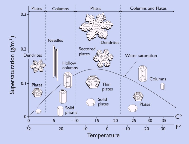
Stellar Dendrites

High SN:H2O were observed in this morning early snowfall reports.

ORH - 23:1
CON - 24:1
BDL - 25:1

Ratios are well above normal.


Image courtesy Cooperative Institute for Precipitation Systems


12z Skew-T from GYX shows cloud-top ~-18°C...the cold edge of favored stellar dendrite growth region. Note the strong warm-air advection near 700 mb acting on the elevated moist layer where mixing ratios reach their maximum value.

Skew-T courtesy SPC.


Snowflake morphology courtesy SnowCrystals.com