Tuesday, October 13, 2009

Snow Season Begins in Japan


From 'Snow Season Japan' blog...

"The first snowfall for the 2009/2010 winter season has arrived on the Hakuba peaks. Hakuba usually sees it’s first snowfall around the middle of October each season, so it’s bang on time. Everything is looking very promising
[...]
"In Japanese, we call the first snow is called Hatsuyuki, Hatsu meaning ‘first’ and Yuki meaning ’snow’"
More...

Winter '09 / '10 - NHEMI Snowcover mid-October

Anomaly / Observed


L-a-r-g-e swath of anomalous snowcover over the northern and central plains...the upper Midwest...and much of Canada.

Miles wide and an inch deep in many places but it/s a good start. Many stations saw their earliest snows on record and others weren/t far behind. Similar reports of early snows elsewhere...as well.

Images courtesy Rutgers Global Snow Lab

Wednesday, October 07, 2009

Winter '09 / '10 - Quick Hit Outlooks

US Department of Energy:
"...slightly milder weather than last winter..."
National Weather Service:
"...equal chances of a mild winter, normal winter or cold winter..."
Weather2000 (chief meteorologist Michael Schlacter):
"...probably average colder than normal and that we can look forward to dramatic swings in temperatures. It's going to be a cyclonic, volatile, wacky winter..."
AccuWeather (senior meteorologist Henry Margusity):
"...expect colder temperatures than last winter and more snow - almost twice as much as last winter's 28 inches in New York City. We're looking at this part of the country being on the cold side..."
More...

Monday, October 05, 2009

Winter '09 / '10 - Early October Snowcover

Judah Cohen...director of seasonal forecasting:

"Scant early snowfall in Siberia indicates Arctic wind patterns may reduce cold air flows into the Northeast U.S. this winter, contradicting forecasts that a weak El Niño will cause the coldest season in a decade, a climate scientist said.

“Our forecast for this winter is pretty warm,” Judah Cohen, director of seasonal forecasting at Atmospheric and Environmental Research Inc. in Lexington, Massachusetts, said yesterday at a conference in New York. “Siberian snow cover has been running well below normal."

"Cohen said a rapid buildup of snow in Siberia this month could alter his forecast that so-called Arctic oscillation patterns will create a warm Northeast.

"“In a week’s time, Siberia can get enough snow to cover the entire U.S.,” he said."
More...

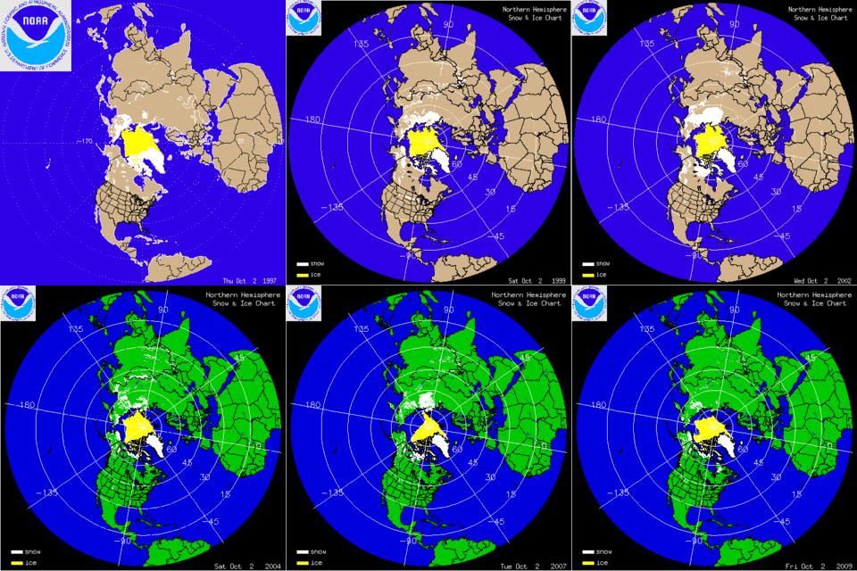
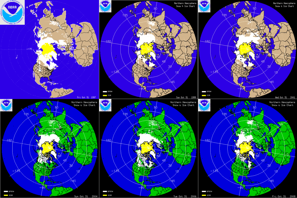
Historical NHEMI Snow Cover 10/2

October 2 1997 - 2009


End of October 1997 - 2009

Appears 2008 Eurasian snowcover was fairly low compared to the other images....and last winter was notable for a good portion of the forecast area.

Associations Between ENSO and AO in Winter

A moderately warm ENSO event seems to be a lock this winter. The multi-variate ENSO Index (MEI) is bullish as are a majority of numerical and statistical ENSO forecast models...even though the Southern Oscillation (data) hasn/t made up its mind.

Conventional wisdom suggests this scenario favors a split-flow regime with an active...moisture-laden sub-tropical jet (STJ) and opportune phasing with the polar jet (PJ) and producing strong cyclogenesis along the eastern seaboard. Add arctic HIGH pressure over eastern Canada and it/s snow-time.

The graphic below was extracted from NCEP/Climate Prediction Center/s ATLAS No. 8 - Relationships Between El Niño-Southern Oscillation and the Arctic Oscillation: A Climate-Weather Link

It shows composite fields for 500 mb geo-potential height...surface temperarture...and precipitation during +ENSO and three phases (positive...neutral...and negative) of the Arctic Oscillation (AO).

Best-case for snow crows during warm ENSO is a negative AO (bottom row of charts).

Otherwise...the mid-level long-wave trof axis is suppressed to the south...(neutral AO) or there/s no trof at all (+AO) and temperatures are above normal with the best moisture contained across the Deep South and the Mississippi and Tennessee River valleys.

Sunday, October 04, 2009

Winter '09 / '10 - WSI

Todd Crawford - Seasonal Forecaster:

"A moderate El Nino event will likely persist through the winter, resulting in cool weather across the Southeast”[...]. “However, ocean temperatures in the North Pacific are not currently supportive of a typical El Nino pattern this upcoming winter. If this persists, this winter will likely be colder in the western US than is typical during El Nino events.

"In the Northeast, we expect a relatively mild fall, with increased chances of sharply colder weather after the New Year. The combination of various climate indices suggests that the winter will likely arrive late but loudly in much of the East, and that a mild start will not necessarily persist through the winter.

"In December, WSI forecasts:
Northeast – Warmer than normal"
More...

Saturday, October 03, 2009

North Atlantic Oscillation - September '09

+1.51

2007...2000...1956...1974...and 1999 are still the best NAO-analog years after the addition of September/s data point. Only change was '74 and '99 switching places from August/s rankings.

What/s it all mean...Mr. Peabody?

2007: -ENSO...+AO...-PDO...-QBO...sun spots below normal
2000: -ENSO...-AO...+PDO...-QBO...sun spots near normal
1956: -ENSO...+AO...-PDO...-QBO...sun spots above normal
1974: -ENSO...+AO...-PDO...-QBO...sun spots below normal
1999: -ENSO...+AO...-PDO...+QBO...sun spots near normal

El Niño more than likely this winter...so how much utility is there using NAO analog years given their unanamous association with -ENSO?

Saturday, September 26, 2009

Winter '09 / '10 - Quasi-biennial Oscillation

The Quasi-biennial Oscillation (QBO) is characterized by alternating easterly and westerly descending wind regimes at the equator. It dominates the variability of the tropical stratosphere. Although the QBO is a tropical phenomenon...it affects the stratospheric flow from pole to pole by modulating the effects of extra-tropical waves. [M. P. Baldwin et.al., 2001 (.pdf)]

The period of oscillation varies between 20 and 36 months...with an average period of about 28 months...as measured over the past half-century. The QBO index at each stratospheric level is the zonally-averaged zonal (east-west) wind. It is the most predictable inter-annual climate fluctuation on the planet.


August QBO @30mb is -14.46 (data)...three months into its nascent easterly phase. It/s expected to remain easterly through spring 2010...reaching its peak amplitude (< -25) during the heart of meteorological winter.

QBO is important b/c it determines the character of the early winter. The east phase leads to a more disturbed and warmer Arctic in December and January. During winter...QBO appears to excite the 'northern annular mode' (aka Arctic Oscillation [Thompson and Wallace, 1998 (.pdf), 2000]. Its easterly phase is represented in composites geo-potential...wind...and temperature fields by a weaker polar vortex (PV)...warmer polar temperatures...and higher geo-potential heights at hi-latitudes. In years with low solar activity...the winter PV tends to be disturbed and weak when the QBO is easterly.

Monthly sunspot activity YTD (data) has been anomalously quiet (lowest 10th percentile) 24 of the past 32 months and every month since April 2008. Top-5 sunspot analog years: 1913...1823...1811...1810...1912.

Reconstructed NAO index (Li) for '12/'13 is 1.44 and '13/'14 is 1.63... neither of which lend any support to a correlation between weak PVs with its implied -AO/-NAO and extremely low sunspot activity.

Top-5 sunspot analogs for years beginning 1950 and their D-J-F AO/NAO: 2008 (0.259/-0.08)...1954 (-0.717/-0.76)...1996 (-0.096/-0.07)...1964 (-1.125/-0.61)...1976 (-2.617/-1.04) supports the correlation.

Polar temperature varies out of phase with sunspot activity (low sunspot activity ==> warmer temperature ==> higher geo-potential heights) for winters when the QBO is easterly. Weak...'warm' PVs are less able to contain arctic air masses at hi-latitudes than cold...strong...less disturbed PVs. This suggests potentially favorable conditions this winter for arctic outbreaks leading to strong baroclinic zones developing between land and water which represent prime conditions for cyclogenesis and block-buster Nor'easters.

Easterly QBO also favors the occurrence of major winter stratospheric warmings [Holton and Tan (1980)(.pdf)]. Stratosphere warmings propagate from 10mb to the surface in ~3 weeks. Should such a warming occur mid-winter during QBO minimum...it could very well signal a cold end to meteorological winter.
-----
Should QBO play a dominant role this winter...

  • Easterly phase during low solar activity ==> favors weak PV
  • Weak PV ==> high heights @ hi-latitudes
  • High heights @ hi-latitudes ==> negative northern annular modes (-AO / -NAO)
  • -AO / -NAO ==> arctic outbreaks + increased east coast snowfalls
  • Easterly phase favors major stratospheric warmings ==> lagged arctic outbreaks

QBO analogs YTD.

1991 is currently the leading analog. Winter '91 / '92 featured +ENSO (albeit one that became strong by spring)...+AO...+NAO...and -SOI...all of which go against type for -QBO. Did anonymously high (96th percentile) monthly sunspots play an active and deciding role?

EDIT: corrected sign of Winter '91 SOI.

Monday, September 21, 2009

Winter '09 / '10 - No Negative NAO

Eastern snow crows are often heard aching for a negative North Atlantic Oscillation (NAO) come winter b/c of its negative correlation to season-total snowfall. Winters where the NAO is...on average...negative (positive)...higher (lower) snowfalls and colder (milder) temperature are more likely.

Buzz-killing evidence is beginning to mount that is sure to disappoint those pining for predictions of a coming negative NAO.

The Developing Case Against Negative NAO

1) The British MET Office's 'positive NAO' forecast is based on SST anomalies in the Northern Atlantic during the month of May. The technique's correlation skill is about 0.45 with the correct sign of the NAO predicted for 66% of all winters. Details here.

2) Trend analysis supports a positive NAO this winter. NAO/s yearly 'winter' average (D-J-F-M) has been positive 21 out of the last 26 years. NAO/s five-year moving-average for the same four months has been positive every year since 1983. Data.

3) Analog years point to positive NAO this winter. NAO has been negative five months this year...three of which occured during meteorological summer. This was also the case the past two summers. July observed its third lowest value (-2.15) since 1950.

Analog years selected using a 'least-squares' regression technique (shown below) are 2007...2000... 1956...1999...and 1974. Monthly NAO values for the analog years are displayed through year/s end.


When monthly NAO index values for the analog years are extended through the winter months of D-J-F...three of the five analog years had a positive monthly NAO index. One analog year/s NAO monthly index was positive during J-F. Another analog year/s NAO monthly index was positive during D-J. NAO analog analysis does not support a forecast for negative NAO this winter. Similar story from the Arctic Oscillation (AO).


4) Contravening evidence is found in the Quasi-biennial oscillation (QBO)...which is beginning its negative phase and will persist throughout the coming winter. QBO/s east phase and solar minimums are correlated with positive high-latitude height anomalies. More about this winter/s QBO here.

---
Negative NAO is not a be all and end all for decent season-total snows...nor is it required for severe winter storms along the eastern seaboard. NAO was positive when The 'Storm of the Century' raked the east coast in mid-March of 1993.

Positive NAO image courtesy Lamont-Doherty Earth Observatory...Columbia U.

Sunday, September 20, 2009

Winter '09 / '10 - AccuWeather - Update

Joe Bastardi...Senior Meteorologist:
"...similar historic weather trends...could herald a bitterly cold winter, particularly for the Northeast and South.

"The closest comparison we’re using for this upcoming winter is the 2002-03 winter season..." Then you have the extreme case of the 1977-78 winter, which is also a possibility. The latter winter held the record for subfreezing temperatures for an unrelenting 51 days."
The Market Oracle