Monday, December 27, 2010

Winter '10 / '11 - Snow Storm #1 - Snow Melt Water

NYC/s 8th Avenue
27-DEC-47
ACY...EWR...and ORF observed not only record-setting snowfalls yesterday but also impressive snow melt water.  Not as generous as the historic 26-DEC-47 storm where 2.53" of melt water was measured in NYC from the 26" snowfall.

ACY - 1.60"
EWR - 1.23" (1.06")
ORF - 1.22"

SN:H2O
ACY - 10.9:1
EWR - 14.2:1 16.7:1
ORF - 11:1


Updated 12/29 to revise EWR data.

Sunday, December 26, 2010

Winter '10 / '11 - Snow Storm #1 - OKX - 0z SkewT-logP

Potent sounding out of OKX tonight.

The rawinsonde's initial low-level flight drifted to the SW over open waters before veering toward Newark...NJ (EWR) and continuing to the north across western New England.  EWR reported TSSN around the time of OKX's 0z balloon flight.

There's a deep...saturated moist layer between the SFC and 600 mb with 50 mb of conditional instability sitting on top.

The specific humidity in the crystal factory @700 mb is 4g/kg or more which can easily support snowfall rates over 1" / hr.  Note the excellent WAA nose @ 700 mb forced strongly by a 40 kt SE wind.

Cloud-tops located near 600 mb (~14K' AGL) where the saturated air temperature is < -15°C ==> perfect conditions for stellar dendrites!

Sounding courtesy NOAA's Storm Prediction Center

Winter '10 / '11 - Snow Storm #1 - Countdown to Blizzard Conditions

Common usage of the term 'blizzard' has come to mean excessive snowfall when in fact...a blizzard is a high-wind event (sustained wind or frequent gusts > 29 kts) that causes a reduction in surface visibility to less than 1/4 SM for at least three hours.

Blizzards are truely rare birds in the eastern CONUS where winter storms usually fail the visibility duration criterion.  One such event may be in the offing tonight...as evidenced by these early observations.

SPECI KTEB 262326Z 36020G30KT 1/16SM R06/1200V1800FT +TSSN BLSN FZFG OVC001 M05/M07 A2943 RMK AO2 PK WND 35031/2258 TSB20 OCNL LTGICCC P0001 $

METAR KJFK 270151Z 34034G42KT 0SM R04R/1600V2200FT SN FZFG BLSN VV001 M06/M07 A2921 RMK AO2 PK WND 35048/0140 SFC VIS 1/8 PRESFR SLP891 SNINCR 1/6 P0003 T10561072 $

METAR KEWR 270251Z 34025G35KT 1/8SM +SN BLSN VV001 M04/M06 A2926 RMK AO2 PK WND 35039/0221 TWR VIS 1/4 SLP909 SNINCR 3/14 P0018 60046 T10441056 58047 RVRNO $

METAR KHPN 270256Z 33028G45KT 0SM +SN BLSN VV001 M08/M11 A2918 RMK AO2 PK WND 34045/0250 SLP891 P0005 60013 T10831106 56058 $

Thunder snow (TSSN) reported at Tetterboro (KTEB)!

Winter '10 / '11 - Snow Storm #1 - The Forecasts

15 entries
3 Intern forecasters
3 Journeyman forecasters
9 Senior forecasters including Chief Forecaster Iralibov

Great turn-out and a great storm for the season opener.
All 27 stations in play making this an excellent test of synoptic-scale snowfall forecasting ability.

All forecasts have been posted to the Contest's web site. Follow the link from Winter '10 / '11 Storm Contest >  Forecasts > Storm #1.

Entries are ranked in ascending order by 'storm-total' snowfall.  Please check you entry for accuracy.

Broad range of expected storm-total snowfall...
Min: 80" (Weathermbug)
Max: 354" (Roger Smith)
Avg: 233"
Median: 254"
STD: 77"


Consensus heavy snowfall axis (+12") between PWM - BOS - PVD - ISP - JFK - EWR - BDR - BDL - ORH - CON - PWM.

Saturday, December 25, 2010

Winter '10 / '11 - Snow Storm #1 - Cyclogenesis

Off-shore waters of GA starting to churn...


Wind picking up...gettin'gusty.
Pressure falling nicely now.

Friday, December 24, 2010

Winter '10 / '11 - Snow Storm #1 - HPC Calls BS on 12z Model Runs

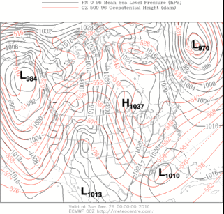
MODEL DIAGNOSTIC DISCUSSION
NWS HYDROMETEOROLOGICAL PREDICTION CENTER CAMP SPRINGS MD
143 PM EST FRI DEC 24 2010

VALID DEC 24/1200 UTC THRU DEC 28/0000 UTC

INITIALIZATION ERRORS IN NUMEROUS DIAGNOSTIC QUANTITIES...INCLUDING HEIGHT/VORTICITY FIELDS/RH...ARE EVIDENT IN BOTH THE 12Z NAM/GFS WITH SMALL BUT LIKELY SIGNIFICANT SHORTWAVE TROUGHS OVER SOUTH DAKOTA/NEBRASKA ALONG WITH SASKATCHEWAN/MANITOBA...WITH THESE AREAS ALSO NOT PARTICULARLY
RESOLVED OR PREDICTED WELL BY THE 00Z ECMWF.

THUS...THE SPECIFIC PREDICTIONS BY ALL DETERMINISTIC GUIDANCE ARE IN QUESTION...WITH THE RECOMMENDATION TO FOLLOW CONTINUITY...WITH THE FINAL OUTCOME MOST BELIEVED TO LIE BETWEEN THE 06Z GFS AND 00Z ECMWF...WITH ALL
ENSEMBLE GUIDANCE INCLUDING THE SREF MEAN/GEFS MEAN (EXCEPT NOT
THE 12Z VERSION)/ECMWF ENSEMBLE MEAN ALSO CONSIDERED USEFUL TO
ADDRESS THE CONTINUED UNCERTAINTY.

THIS APPROACH DISREGARDS THE SUBSTANTIALLY DEEPER AND WESTWARD SHIFT OF THE 12Z GFS REGARDING THE POWERFUL LOW TRACKING UP THE EASTERN SEABOARD...AND TO A LESSER EXTENT THE 12Z NAM WHICH LIES NEAR THE FAST EDGE OF THE GUIDANCE WITH THE DEVELOPING LOW.

Winter '10 / '11 - Snow Storm #1 - Call for Forecasts

NYC
27-DEC-47
Plenty-of-uncertainty about the eventual fate of the this weekend/s long anticipated east coast LOW and its attendant rapid cyclogenesis.  Today's 12z NAM has the yin while the 12z GooFuS is really yanging it up.

GooFuS hands the reins over to a strong 100kt digging short-wave in the northern stream SAT afternoon...a significant change from early projections where the main energy was contained in the southern stream.  Coupled-jet streak configuration noted around mid-day SUN.  Could be a notable event should the atmopsphere decide to read from this script.

Contest may be canceled prior to the deadline if NWP indicates a fizzling event.

-----
Deadline: 10:30 PM EST SAT...25-DEC-10
Forecast element: storm-total snowfall
Verification begins: 12:01 AM EST SUN...26-DEC-10
Verification ends: 11:59 PM EST MON...27-DEC-10

Enter your forecast at the Contest web site here.
Follow the link from 'Enter Storm Forecast.'

As always...there/s no cost...or fee...advertising...or annoying requests for personal information to enter. It's just a fun exercise among winter wx enthusiasts to see who can make the best synoptic-scale snowfall forecast.

If you are issuing your first forecast this year...or you entered the 'season-total' forecast contest...you/ll need to create an account (user name / password / valid e-mail...if you want a copy of your forecast sent to your Inbox).

If you want to be notified via e-mail when a 'Call for Forecasts' is issued...please let me know @ newx at newx-forecasts dot com.

Wednesday, December 22, 2010

Winter '10 / '11 - Stratospheric Warming - Another Try


Last signal failed to pan-out.  Probability a long-shot given the poor odds for warmings with QBO in its positive / west phase....except when sunspot activity is high.

ECMWF hinting again at a break in the polar vortex (PV) last next week.

Note 1) the PV's pending split with separate circulation developing over the pole / central Russia and 2) the yellow area north-west of the Hudson Bay.  The yellow indicates warmer temperature at 100 mb which implies a very cold troposphere.  The slug of warm stratospheric air originated --- and is usually found -- over Siberia.

Winter '10 / '11 - Season-total Snowfall Forecast Contest - Forecast Summary

Individual forecasts on the Contest web site here.

Winter '10 / '11 - Coastal Teaser

Grinch appears to have stolen a white Christams for portions of the mid-Atlantic this year...which may turn out to be a good thing in the end.

Recent EC projections for a late weekend storm have been slower and stronger than GooFUS.  Today's 12z GooFUS is now coming in line with the EC solutions such that the season's 1st contest-worthy storm may be in the offing come SUN.

A 'Call for Forecasts' is possible FRI...with an entry deadline of 10:30 PM EST...SAT 25-DEC-10.