Wednesday, January 02, 2013

Winter '12 / '13 - Long Range Forecast: Farmer/s Almanac

Two Towers - New York
Alfred Stieglitz
OCT-1911

January 2013
1st-3rd. Showery, then clearing and cold. Wet for Mummers Day Parade in Philadelphia.
4th-7th. Storm sweeps across Pennsylvania and New York with gusty winds and heavy precipitation.
8th-11th. Blustery and colder; snow showers.
12th-15th. Mostly fair.
16th-19th. Wet, then fair and cold.
20th-23rd. Heavy snow (half foot or more) for New England; lighter amounts farther south.
24th-27th. Scattered flurries.
28th-31st. Sharp cold front brings rain and snow showers, then clearing and cold.

February 2013
1st-3rd. Fair.
4th-7th. A sharp cold front brings gusty winds, rain, and snow showers.
8th-11th. Unsettled; light snow and flurries.
12th-15th. Major Northeast snowstorm develops: some accumulations could exceed one foot; strong winds cause considerable blowing of snow.
16th-19th. Lingering snow showers, flurries.
20th-23rd. Blustery and cold.
24th-28th. A major storm over the ocean perhaps brushes the coast with light snow and gusty winds, then turning fair.

More...

Winter '12 / '13 - SOI: December


December/s SOI (Southern Oscillation Index) came in at -6 after three consecutive months where the index went above zero.

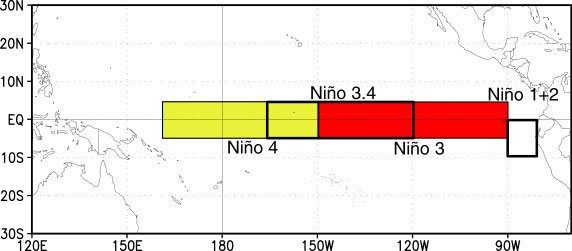
A negative SOI is associated with above normal sea surface temperatures (SST) in ENSO Region 3.4 in the tropical Pacific.  Sustained SOI < -8 indicates el Nino.

Weekly SST anomalies from Region 3.4 have been running a tenth or two below normal the past four weeks causing the 12-week moving average to fall to 0.18 (neutral-warm).


ENSO Region image courtesy CPC

Monday, December 31, 2012

Winter '12 / '13 - Storm #2: Final Results

1st - donsutherland1
SUMSQ:
77.41

SUMSQ Z:
-1.049

STP:
13.15
 (5)
TAE:
30.45
 (1)
AAE:
1.45
 (2)


2nd - Brad Yehl
SUMSQ:
78.27

SUMSQ Z:
-1.040

STP:
10.15
 (4)
TAE:
31.05
 (2)
AAE:
1.29
 (1)
3rd - snocat918
SUMSQ:
104.51

SUMSQ Z:
-0.752

STP:
7.55
 (3)
TAE:
39.55
 (5)
AAE:
1.72
 (4)


HM - Donald Rosenfeld
SUMSQ:
112.59

SUMSQ Z:
-0.663

STP:
1.10
 (1)
TAE:
40.20
 (6)
AAE:
1.83
 (6)


SUMSQ: sum of square errors
STP: storm-total precipitation error
TAE: total absolute error
AAE: average absolute error
(number):  category rank

Full forecast verification and summary at the Contest/s home page.

Sunday, December 30, 2012

Winter '12 / '13 - Storm #1: Final Results


1st - dryslot
SUMSQ:
112.98

SUMSQ Z:
-0.887

STP:
5.26
 (4)
TAE:
39.64
 (6)
AAE:
1.80
 (5)
2nd - herb@maws
SUMSQ:
119.42

SUMSQ Z:
-0.846

STP:
13.79
 (7)
TAE:
36.79
 (3)
AAE:
1.75
 (3)
3rd - Brad Yehl
SUMSQ:
213.38

SUMSQ Z:
-0.782

STP:
2.65
 (3)
TAE:
35.75
 (2)
AAE:
1.62
 (2)
HM - Donald Rosenfeld
SUMSQ:
140.87

SUMSQ Z:
-0.711

STP:
0.99
 (1)
TAE:
33.99
 (1)
AAE:
1.55
 (1)

SUMSQ: sum of square errors
STP: storm-total precipitation error
TAE: total absolute error
AAE: average absolute error
(number):  category rank

Full forecast verification and summary at the Contest/s web site.

Winter '12 / 13 - Storm #2: Preliminary Verification


Preliminary storm-total snowfalls for Saturday from CDUS41 and CXUS51 bulletins.

Several stations in the data table do not have SN:H2O reported b/c their liquid totals included mixed precipitation.

CON STP of 2.6" at 10:1 is suspect given surrounding amounts and much higher ratios.

---
Two new daily records.
SAT...29-DEC-12
BDR - 3.5" (3.1"; 1959)
IAD - 0.9" (0.3"; 1993)

---
Please report any errors and drop a link to the correct data in Comments.

Final results and storm summary Monday evening.

Saturday, December 29, 2012

Winter '12 / '13 - Storm #2: The Forecasts

Consensus for a southern NE and northern M-A event.


12 forecasters
3 Rookies...two of which issued their 1st forecast for Storm #2.

Welcome Kevinmyattwx and quagmireweathercentral!
Forecaster answer7 is now an Intern.


Forecasts are ranked by their storm-total precipitation (STP).
BLUE ==> 25th percentile.
RED ==> 75th percentile.
STP cells without color are between the 25th and 75th percentile.

Everyone/s station-by-station forecast at the Contest/s web site.

---

Slight amplification in the long-wave flow regime suggested by +PNA.  -AO getting the job done again as its sister index the +NAO offers more evidence of how unimportant she is to snowfall on the east coast.

Winter '12 / '13 - Storm 1: Preliminary Verification


Preliminary storm-total snowfalls for Wednesday through Friday from CDUS41 and CXUS51 bulletins.

Several stations in the data table do not have SN:H2O reported b/c their liquid totals included mixed precipitation.

SN:H2O for CON appears low in light of METARs reported only SN.

---
Two new daily records.
THU...27-DEC-12
PWM - 11.6" (8.8"; 1894)
CAR - 6.2" (6.2"; 2010)

---
Please report any errors and drop a link to the correct data in Comments.

Final results and storm summary Sunday evening.

Friday, December 28, 2012

Winter '12 / '13 - Storm #2: RAW Forecasts


NYC - 5th Avenue
1905
RAW forecasts here.

# Forecasters: 12
Two fresh Rookies.

Marginal event but what the hay.  Best case scenario...the plows will be out on the road.

In hindsight...should have left the verification period open ended.  When the 'Call for Forecasts' was issued on THU...NWP indicated most of the snow would have fallen by 11:59 PM SAT.  Later guidance suggested otherwise.

Storm #2 forecast summary and all individual forecasts will be posted to the Contest/s web log and / or web site by Saturday evening.

Thursday, December 27, 2012

Winter '12 / '13 - Storm #2: Call for Forecasts!

NYC
27-DEC-47

Another Miller A-B hybrid storm heading toward the forecast area.

Southern stream LOW forms in the Gulf of Mexico.  Second decaying LOW INVOF the Great Lakes drifting east in the northern stream.

Stronger GOM LOW captures the Lake's LOW over the western M-A.  Rapid deepening near the 40/70 benchmark late in the period as the storm kicks out to sea.  Mainly a rain event over the water and contest-worthy snows over the northern M-A and SNE.

Storm #2 potential appears marginal at post time where the best case scenario produces widespread plowable snowfall; however...there are equal chances for widespread nuisance amounts.

The forecast contest for Storm #2 may be canceled prior to deadline if NWP indicates a fizzling event.

---
Forecast element: storm-total snowfall
Deadline for entries: 10:30 PM EST FRI...28-DEC-12

Verification period begins: 12:01 AM SAT...29-DEC-12
Verification period ends: 11:59 PM SAT...29-DEC-12

Enter your forecast at the Contest's home page here.
Follow the link from 'Enter Storm Forecast.'

---
As always...there/s no cost...or fee...or advertising...or annoying requests for personal information to enter a forecast. It's just a fun exercise for winter wx enthusiasts to see who can make the best synoptic-scale snowfall forecast.

If you are issuing your first forecast this winter...or you entered the 'season-total' forecast contest...you/ll need to create an account (user name / password / valid e-mail...if you want a copy of your forecast sent to your Inbox).
---

Want to be notified via e-mail when the 'Call for Forecast' is issued?
Send requests to 'newx at newx-forecasts dot com'.

Wednesday, December 26, 2012

Winter '12 / '13 - Storm # 1: The Forecasts

Consensus for this season/s inaugural event has bonus snows for New England/s northern stations and crumbs for most inland locations along the mid-Atlantic.  The eight to 10 stations in play makes this a decent synoptic-scale winter storm despite rain for major cities along the I-95 corridor.


13 forecasters
11 veterans and 2 Rookies


Forecasts are ranked by their storm-total precipitation (STP).
BLUE ==> 25th percentile.
RED ==> 75th percentile.
STP cells without color are between the 25th and 75th percentile.

Everyone/s station-by-station forecast at the Contest/s web site.

---
Roger Smith is promoted to Senior forecaster this year.
Brad Yehl is now a Journeyman forecaster.
Dryslot is an Intern.

Forecaster status - Years Experience
Rookie - 0
Intern - 1
Journeyman - 2
Senior - 3
Chief - last year/s 'Regular' season contest winner.

---


PNA at long last comes out of its long coma and a good looking AO although a fair case can be made the state of these indices played a relatively minor role.