Monday, January 26, 2015

Winter '14 / '15 - Storm #2: The Forecasts!

Rookies 0
Interns 0
Journeymen 2
Senior 12
TOT 14

Total station forecasts: 357


Forecasts are ranked by their storm-total precipitation (STP).
BLUE ==> 25th percentile.
RED ==> 75th percentile.
STP cells without color are between the 25th and 75th percentile.

---
 
Heaviest snowfall (+20") consensus along a line from BOS - PVD - ISP - BDR - BDL - ORH - BOS.
 
---
CPC/s tele-connection data file is FUBAR today ... so there/s no trend analysis graphic.
 
NEWxSFC can report the AO is and has been positive and trending up ... the NAO is and has been positive and trending up ... and the PNA is and has been positive and trending down.
 
How is it even remotely possible to have an historic snow storm along the east coast when all the supposedly important tele-connections indices are upside-down?
 
IDK.
The so-called '93 'Storm of the Century' had the same issues.
 
---

Forecaster/s station-by-station entries for Storm #2 available at the Contest/s web site.

Saturday, January 24, 2015

Winter '14 / '15 - Storm #2: Call for Forecasts!

NYC
27-JAN-1937
Garden-variety Alberta clipper sliding out of Canada at post time progged to dig into the coastal waters off the Carolina then morph into a Sutcliffe-Petterssen 'self-development'* coastal bomb INVOF the famed 40°N / 70°W benchmark.

* - http://fas.org/spp/military/docops/afwa/atmos-U3.htm
Scroll to "Self-development/intensification of a baroclinic low"

 ---
Forecast element: storm-total snowfall
Deadline for entries:  10:30 PM EST ... SUN ... 25-JAN-15

Verification period begins:  12:01 AM EST ... MON ... 26-JAN-15
Verification period ends:  11:59 PM EST ... WED ... 28-JAN-15

---
Enter your forecast at the NEWxSFC/s home page here.
Follow the top-of-page link from 'Enter Storm Forecast.'

---
As always ... there/s no cost ... no fee ... no advertising ... or annoying requests for personal information to enter a forecast.  It's just a fun exercise for winter wx enthusiasts to see who can make the best synoptic-scale snowfall forecast.

 ---
If you are issuing your first forecast this winter...or you entered the 'season-total' forecast contest ... you/ll need to create an account (user name / password / valid e-mail ... if you want a copy of your forecast sent to your Inbox).

---
Hard to believe the last 'Call for Forecasts' was issued two months ago ... all the way back on 25-NOV-14

Only three years (2000, 2007, 2012) where there no contest-worthy storms in DEC.
Only two years (2007, 2013) where there no contest-worthy storms in JAN.

Even FEB is not immune to no-hitters (2002, 2009).
The good news is early FEB looks quite promising.

Probably get two in APR (h/t snowman).
Last and only time that happened was 2002.

Monday, January 05, 2015

Winter '14 / '15 - Weakening Polar Vortex ==> Sudden Stratospheric Warming: UPDATE 6

OBS
The current sudden stratospheric warming (SSW) event has likely peaked as evidenced by
1)   the deep layer wind reversal of the polar vortex (PV) and
2)  a dipole of hi-latitude warming maximized INVOF eastern Greenland.

Image:  10-hPa temperature change in a week in the Northern Hemisphere (courtesy Tokyo Climate Center, Climate Prediction Division).  The contour interval is 5 °C. The pink and light blue shadings indicate warming and cooling, respectively. The red shading denotes warming for values higher than 25 °C.

Upper air analysis courtesy University of Wyoming, College of Engineering, Department of Atmospheric Science

---
Deep-layer hi-latitude easterlies ~30 KTs.

 
 ---
Arctic Oscillation (AO) poised to tank by mid-month.
 
 
D+11 prog of a near-perfect AO tri-pole and a stationary... four-wave pattern.
 
 
---
Bonus OB:  DEC QBO dipped to -25.35.
 

Wednesday, December 31, 2014

Winter '14 / '15 - Weakening Polar Vortex ==> Sudden Stratospheric Warming: UPDATE 5

"Overall, the easterly winds descending into the lower tropical stratosphere is continually favorable for redirecting tropospheric waves anomalously poleward, which increases the odds of interaction with the stratospheric polar vortex and hence increases the chances of a SSW event this winter. (AER)

OBS


CPC - Stratosphere-Troposphere Monitoring

---
First sign of sudden warming at 30 mb

30-hPa temperature change in a week in the Northern Hemisphere
The contour interval is 5 °C. The pink and light blue shadings indicate warming and cooling, respectively. The red shading denotes warming for values higher than 25 °C.
 
Tokyo Climate Center, Climate Prediction Division
 
---
PROGS
NWP projecting a return to above-normal temperatures around mid-JAN.
Have they accounted for the effects from this SSW event?

Tuesday, December 30, 2014

Winter '14 / '15 - Weakening Polar Vortex ==> Sudden Stratospheric Warming: UPDATE 4

OBS
Expanding area at 10 mb over Siberia (red shading) where the one-week temperature change exceeds 25°C.
 
10-hPa temperature change in a week in the Northern Hemisphere

The contour interval is 5 °C. The pink and light blue shadings indicate warming and cooling, respectively. The red shading denotes warming for values higher than 25 °C.
 
Imagery courtesy Tokyo Climate Center, Climate Prediction Division
 
---
PROGS
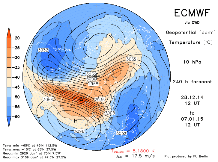
The 12z / 29-DEC-14 ECMWF suggests the 'split-vortices' SSW portion of the current event will peak between 03 / 06-JAN-15 followed by displacement. on D+10.


Deep-layer easterlies depicted on 03-JAN.
Short-lived daughter vortices appear briefly at the 475K level on 06-JAN.

Displacement
 
---
SSW TYPES 


Sunday, December 28, 2014

Winter '14 / '15 - Weakening Polar Vortex ==> Sudden Stratospheric Warming: UPDATE 3

Minor warming in progress INVOF Siberia.

 
10-hPa temperature change in a week in the Northern Hemisphere
The contour interval is 5 °C. The pink and light blue shadings indicate warming and cooling, respectively. The red shading denotes warming for values higher than 25 °C.
 
"A stratospheric warming is called 'minor' if a significant temperature increase is observed ([...] >= 25°C in a ... week or less) at any stratospheric level in any area of winter time hemisphere. The polar vortex is not broken down and the wind reversal from westerly to easterly is less extensive." (REF)
 
Imagery courtesy Tokyo Climate Center, Climate Prediction Division

Major warming appears imminent.


"Major SSWs occur when the westerly winds at 60N and 10 mb  reverse direction. A complete disruption of the polar vortex (PV) is observed.  The PV will either be split into daughter vortices ... or be displaced from its normal location over the pole." (WMO)

Friday, December 26, 2014

Winter '14 / '15 - Weakening Polar Vortex ==> Sudden Stratospheric Warming: UPDATE 2

The 12z / 25-DEC-14 run of the ECMWF continued its current campaign for a sudden stratospheric warming (SSW) event come JAN.


Progs suggest the birthing of daughter vortices around 04-JAN-15 induced by the upward propagation of a large tropospheric Rossby wave in a QBO-east environment.  A 'major' SSW event is indicated.
 
"A major SSW occurs when the 10 mb 60°N zonal mean zonal wind reverses from westerly to easterly and the 10 mb zonal mean temperature gradient increases poleward of 60°N." (.pdf)
 
Another view of the impeding split at the 475K level from a potential vorticity (NASA) perspective ... 
 
 
The downward propagation of the stratospheric easterly circulation (or a significant weakening of west wind) and the establishment of the Arctic Oscillation (AO) in its negative phase usually follows major SSW events.


Thursday, December 25, 2014

Winter '14 / '15 - Weakening Polar Vortex ==> Sudden Stratospheric Warming: UPDATE 1

The 12z / 24-DEC-14 run of the ECMWF continued its current campaign for a sudden stratospheric warming event come JAN.


Latest progs point to a weakening and splitting of the stratospheric polar vortex (PV) ... a flip in the high-latitude deep-layer tropospheric flow from W-to-E ... and the ginning-up an anti-cyclonic circulation INVOF 90°N ... all of which point to the near-term development of a negative state for the Arctic Oscillation (AO) and all that implies.

Monday, December 22, 2014

Winter '14 / '15 - Weakening Polar Vortex ==> Sudden Stratospheric Warming


Output from the ECMWF 12z / 21-DEC-14 run shown below forecasts
1)  significant weakening of the PV from 145 KT at initialization to 50 KT on the 240-hr prog and
2)  beginnings of a PV reversal (mean easterly wind above 5 mb)
3)  maintenance of a strong sub-tropical jet (STJ)


"Pronounced weakenings of the NH wintertime stratospheric polar vortex tend to be followed by episodes of anomalously low surface air temperatures and increased frequency of occurrence of extreme cold events throughout densely populated regions such as eastern North America, northern Europe, and eastern Asia that persist for ~2 months."
REF:  http://www.nwra.com/resumes/baldwin/pubs/Thompsonetal_2002.pdf

QBO/s SUPPORTING ROLE 
Winters in a negative / easterly QBO regime favor PV weakening and subsequent SSW events.  In years with low solar sunspot activity ... the polar winter vortex also tends to be disturbed and weak when the QBO is easterly; however ... solar sunspot activity is neither high nor low.

FWIW 
Top three QBO analog years are 1972 ... 1958 ... and 2009.

1972/3 - strong el Nino
1958/9 - weak el Nino
2009/10 - moderate el Nino

QBO phases typically last ~13 months before reversal.
The QBO is seven months into its east phase through NOV-14 and will remain negative throughout this winter.

Winter '58 / '59 snowfall in the southern M-A was well above normal ... central M-A and NNE much below normal ...  and SNE below normal.

OUTLOOK
The time to propagate a SSW-induced west-to-east flow reversal from 10 mb to the near-surface is variable but averages ~3 weeks.  All else equal ... should the 12z 21-DEC-14 ECMWF perfect-prog verify ... the full effects associated with a persistently negative Arctic Oscillation (AO) would not be felt at the surface until late JAN at the earliest.