Winter '12 / '13 - Stratospheric Sudden Warming: Watch #2
UPDATE #3
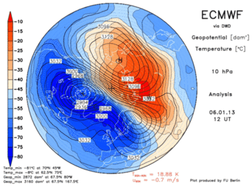
Current SSW event can now be classified as a major warming. Temperatures have increased ~50°C in less than seven days AND zonally averaged winds @60°N have turned easterly.

Max 10 mb (31,242m; ~50K') temperature @12z today was -22°C (-7.6°F) over Viljujsk...Russia (map).
Why is SSW matters...
Pronounced weakenings of the NH wintertime stratospheric polar vortex tend to be followed by episodes of anomalously low surface air temperatures and increased frequency of occurrence of extreme cold events throughout densely populated regions such as eastern North America, northern Europe, and eastern Asia that persist for ~2 months.http://www.nwra.com/resumes/baldwin/pubs/Thompsonetal_2002.pdf
Pronounced weakening of the PV (cool colors) as it splits in two bya strong anticyclone advancing on 90°N...

10 mg height analysis courtesy JMA.

Warm colors indicate east wind. Polar wind field along left edge of frame. Anticyclonic circulation is strongest above 10 mb and extends to surface. Blue action center near 30N @ 200 mb is the sub-tropical jet.
Height-Latitude Cross Section of Zonally Averaged Zonal Wind image courtesy JMA.
---
UPDATE #2 (7-JAN-13 @ 7:08 PM EST)
 |
| North- South 0° - 180W° East - West 90°E - 90°W |


Just a hint of the warming down to ~30 mb along seen on the right edge of the above image.

Not the wave flux above 100 mb...especially in the final frame...where the 'hot' colored vectors veer toward the pole indicating energy propagating from the troposphere into the poleward Ignorosphere.
ECMWF forecasts the PV to bifurcate and maintain that state through D+10 as anticyclone builds over 90N. CW has it the anticyclone propagates to the surface in a few weeks where -AO becomes established. Some unknown location in the mid-latitudes can probably expect a Mother lode of cold toward the end of January.
---
UPDATE #1 (30-DEC-12 @ 1:58 PM EST)
Strong anticyclone forecast at D+10 (blue region in upper right of frame).

At present...the coldest tropospheric air sets up over Alaska and Canada/s NW Territories.
Huge implications for second half of winter should this come to pass and propagate to the surface.
---
Original post: 25-DEC-12 @ 11:58 AM EST
Evidence abounds for a weakened stratospheric polar vortex (PV) and a circulation reversal over high latitudes.
Note the warm colors on the left side of the cross-section shown below marking the area where the flow has become easterly.

EP flux offers more evidence of stratospheric warming.
Note how along along the bottom row of panels the vectors in the 100 - 20 mb layer ascend and veer toward higher latitudes indicating wave energy's upward propagation from the troposphere.

An weak warming was observed in early DEC as indicated by the easterly winds on the time-height cross section shown below. The image also detects the in-progress PV reversal.

The ECMWF D+10 prog shown below suggests the PV will continue its weakened condition its depiction of a building anticyclonic aloft and possibly building toward the surface in the medium range. This progression favors HIGH pressure INVOF the Pole and negative annular mode oscillations (AO; NAO).

Image courtesy Institute of Meteorology: Stratospheric Diagnostics


3 comments:
I think the "unknown" destination of the motherlode of cold will be western Europe. The Siberian cold air is massing and the recent Middle East storm has pushed very mild air into central Asia (23 C in Uzbekistan today) ... this will push the Siberian high northwest and topple it into western Russia within a week to ten days, then on to Scandinavia and eventually a ridge will build to Iceland.
The British Isles should prepare for a major winter onslaught in late January and February, and all of Europe will soon be into the first phases of this perhaps historic cold spell. -- Roger Smith
Agreed.
The EC's Ignorospere progs suggest the Mother lode crash lands in weatern Europe.
A second motherlode lands in the northeast U.S. :)
Could be down around -30 F in upstate NY and eastern Canada by this time next week.
Looks like it could snow on Obama's parade and maybe just maybe another contest? But a Burlington and Caribou event on Sunday, 10-15 inches possible up that way. I'm loving it. -- R.S.
Post a Comment