Thursday, October 15, 2009

Winter '09 / '10 - Building or Fading el Niño?

NOAA bets the farms on a building el Niño this winter while AccuWx leans the other way with its expectation of a fading +ENSO.

Despite the decidedly different expectations...their temperature and precipitation charts appear surprisingly similar.

SST measurements in ENSO Region 3.4 are currently reporting weak +ENSO conditions (12-week moving average SSTanom +0.7°C having peaked @0.9°C 16-Sep).  Anomalies have risen in Region 4 to 1.0°C as the center of action shifts toward the International Dateline.


Winter '09 / '10 - National Wx Circus


"Northeast: Equal chances for above-, near-, or below-normal temperatures and precipitation. Winter weather in this region is often driven not by El Niño but by weather patterns over the northern Atlantic Ocean and Arctic, such as the North Atlantic Oscillation. These patterns are often more short-term, and are generally predictable only a week or so in advance."
Despite NOAA/s caveat about the North Atlantic Oscillation with its implicit association with the Arctic Oscillation...the 'cooler' temperature outlook along the SE coast is predicated upon the Northern Annular Modes being negative...otherwise the temperature fields would look like this.

More...

Winter '09 / '10 - How Much for Balmer?

Frank Roylance...staff writer for the Baltimore Sun...also interviewed AccuWx/s Chief Meteorologist Joe Bastardi...who offered up additional details about what's in store for Baltimore this winter.
"Maryland is in for the coldest, snowiest winter we've seen since the memorable - and snow-choked - winter of 2002-2003.

"A "fading" El Niño, and a shift to a warm phase of the "Pacific Decadal Oscillation" will combine with "other factors," Joe Bastardi said, to shift the worst of this winter's weather from the Midwest, where it was concentrated last winter, to the mid-Atlantic states.

"Twenty-five inches at BWI, and 2.7 degrees below normal," he said, placing his bets on the season's total snowfall at the airport and the average temperature for the winter at BWI.

"Among the "other factors" he takes into account, in addition to El Niño and the Pacific Decadal Oscillation, are the prevailing weather conditions and how they compare with past winters - winter analogs. Looking at those, he sees similarities between this year's patterns and those that prevailed during the winters of 1976-77, which was very cold, and 1977-78, which saw 34 inches of snow at BWI.

"He also saw a resemblance to the winter of 1957-58, which brought 43 inches of snow to Baltimore and very wintry weather in February and March. Another "analog" he includes in his "package" is the winter of 1965-66, with 32 inches of snow."
Average season-total snowfall @BWI: 21.4" AccuWx/s expecting 17% more snow than normal.  Last year/s forecast was 20" with 9" observed.

BWI Monthly Snowfall Climo (58-year NCDC period of record)
DEC: 3.3"
JAN: 6.1"
FEB: 7.1"
MAR: 3.6"

More...

Winter '09 / '10 - How Much for Philly?

Anthony Wood...staff writer for the Philadelphia Inquirer...interviewed AccuWx/s Chief Meteorologist Joe Bastardi...who offered up a few additional details about what's in store for Philly this winter
"...temperatures to be about 2 degrees below average...with perhaps 30 inches of snow.

"I do think there are going to be a couple of big-ticket storms..."
Average season-total snowfall @PHL: 21" AccuWx/s expecting 43% more snow than normal.

PHL Monthly Snowfall Climo (66-year NCDC period of record)
DEC: 3.4"
JAN: 6.0"
FEB: 7.0"
MAR: 3.4"

More...

Wednesday, October 14, 2009

Winter '09 / '10 - AccuWeather - Update 2


Joe Bastardi...Chief Meteorologist:
"...winter will be centered over an area from Maryland to the Carolinas as a fading El Niño results in the stormiest and coldest pattern in recent years.

"The areas that will be hit hardest this winter by cold, snowy weather will be from southern New England through the Appalachians and mid-Atlantic, including the Carolinas. Areas from Washington D.C. to Charlotte have had very little snowfall the past two winters. This season these areas could end up with above-normal snowfall.

"Northern areas, including Buffalo, Boston and Maine, have been hit hard the past couple of winters, but will see normal snowfall with temperatures slightly below normal this winter.

"Cities such as New York, Boston and Philadelphia could get up to 75 percent of their total snowfall in two or three big storms."
This is a classic +ENSO / -Arctic Oscillation (AO) forecast with main precipitation track across the southern tier and Miller 'A' (.pdf) nor'easters up the east coast...although it does not appear to be a good fit with the accompanying temperature outlook...which matches closely to either a positive or neutral AO state.

More...

Tuesday, October 13, 2009

Early Snows in Austria

(updated below)

"Austria’s provincial capitals are expected to see their earliest snowfalls in history today (Mon) as Arctic air sweeps the country."
[...]
"The (previous) record for early snow in provincial capitals was set in 2007, when snow remained on the ground in some of them from 20 to 24 October."

More...

UPDATE:
"Austria sees biggest October snowfall in 25 years"

"Austria was hit by a record October snowfall late on Tuesday when strong winds and heavy snow caused power blackouts, train delays and traffic accidents.

"...also predicted...30 and 40 centimeters (12 - 16") of snow would be likely to fall this week."
More...

Snow Season Begins in Japan


From 'Snow Season Japan' blog...

"The first snowfall for the 2009/2010 winter season has arrived on the Hakuba peaks. Hakuba usually sees it’s first snowfall around the middle of October each season, so it’s bang on time. Everything is looking very promising
[...]
"In Japanese, we call the first snow is called Hatsuyuki, Hatsu meaning ‘first’ and Yuki meaning ’snow’"
More...

Winter '09 / '10 - NHEMI Snowcover mid-October

Anomaly / Observed


L-a-r-g-e swath of anomalous snowcover over the northern and central plains...the upper Midwest...and much of Canada.

Miles wide and an inch deep in many places but it/s a good start. Many stations saw their earliest snows on record and others weren/t far behind. Similar reports of early snows elsewhere...as well.

Images courtesy Rutgers Global Snow Lab

Wednesday, October 07, 2009

Winter '09 / '10 - Quick Hit Outlooks

US Department of Energy:
"...slightly milder weather than last winter..."
National Weather Service:
"...equal chances of a mild winter, normal winter or cold winter..."
Weather2000 (chief meteorologist Michael Schlacter):
"...probably average colder than normal and that we can look forward to dramatic swings in temperatures. It's going to be a cyclonic, volatile, wacky winter..."
AccuWeather (senior meteorologist Henry Margusity):
"...expect colder temperatures than last winter and more snow - almost twice as much as last winter's 28 inches in New York City. We're looking at this part of the country being on the cold side..."
More...

Monday, October 05, 2009

Winter '09 / '10 - Early October Snowcover

Judah Cohen...director of seasonal forecasting:

"Scant early snowfall in Siberia indicates Arctic wind patterns may reduce cold air flows into the Northeast U.S. this winter, contradicting forecasts that a weak El Niño will cause the coldest season in a decade, a climate scientist said.

“Our forecast for this winter is pretty warm,” Judah Cohen, director of seasonal forecasting at Atmospheric and Environmental Research Inc. in Lexington, Massachusetts, said yesterday at a conference in New York. “Siberian snow cover has been running well below normal."

"Cohen said a rapid buildup of snow in Siberia this month could alter his forecast that so-called Arctic oscillation patterns will create a warm Northeast.

"“In a week’s time, Siberia can get enough snow to cover the entire U.S.,” he said."
More...

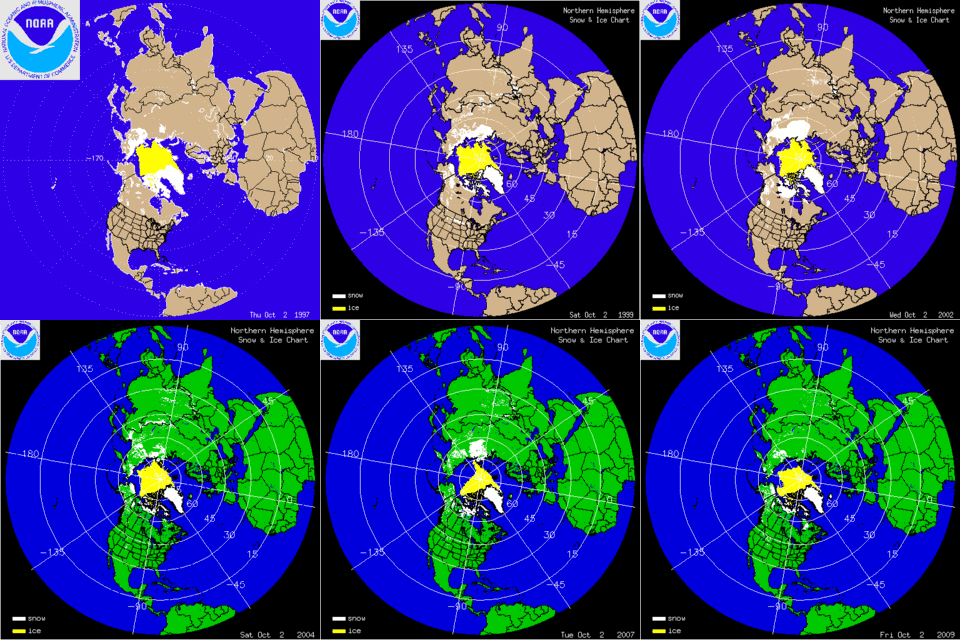
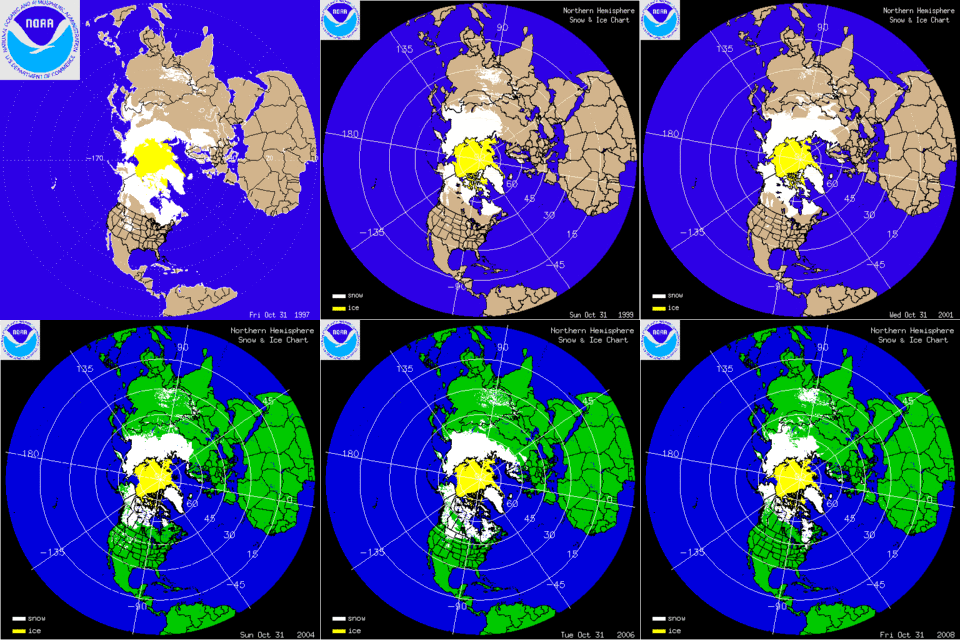
Historical NHEMI Snow Cover 10/2

October 2 1997 - 2009


End of October 1997 - 2009

Appears 2008 Eurasian snowcover was fairly low compared to the other images....and last winter was notable for a good portion of the forecast area.