Saturday, January 09, 2010

Winter '09 / '10 - CONUS Snow Cover

With the mid-point of meteorological winter a week away...

CONUS current areal coverage by snow:  62.7%
CONUS areal coverage by snow last month:  55.5% 


Impressive!

Above normal snow cover in the OH and TN River valleys.

Image courtesy NOHRSC

Winter '09 / '10 - Winter Temperatures and the Arctic Oscillation


From NASA/s Earth Observatory...


"This image illustrates how cold December was compared to the average of temperatures recorded in December between 2000 and 2008. Blue points to colder than average land surface temperatures, while red indicates warmer temperatures. Much of the Northern Hemisphere experienced cold land surface temperatures, but the Arctic was exceptionally warm. This weather pattern is a tale-tell sign of the Arctic Oscillation."
More...

The AO is a response to forcing...not a forcing in and of itself.

What caused the cold outbreak was a stratospheric warming event during late NOV / early DEC.  This caused the polar vortex to slow...split in two...and reverse direction...creating an anti-cyclonic (clock-wise) circulation aloft. The reversal took ~3 weeks to propagate to the surface...creating HIGH pressure over the pole....which in turn created favorable conditions for arctic outbreaks and high-latitude blocking...such as the one currently observed.

These reversal events occur preferentially during years (such as this one) where an east wind is observed in the tropical stratosphere...the quasi-biennial oscillation - QBO...and solar activity (sunspots) is low. Above normal snowfall in eastern Eurasia this fall played a significant role in initiating the stratospheric warming event.

HIGH pressure @high-latitudes is indicative of negative NAO and negative Arctic Oscillation (AO); however...to blame the cold on -NAO / -AO is just plain wrong.

Thursday, January 07, 2010

Winter '09 / '10 - ECHAM5

Latest hemispheric sea-level deviation forecasts from ECHAM5.

RED: negative deviations
BLUE: positive deviations


JAN:  Aleutian LOW pressure is forecast to persist as well as the current storm track into the Mediterranean Sea.  Strong HIGH pressure deviations centered over NW Russia suggesting a shift of the high-latitude block now east Greenland will continue to drift.

Pressure configuration over CONUS is suggestive of persistent +PNA flow regime...a continuation of arctic air masses sweeping through the east coast...and the potential for snow storms from 'Alberta Clipper' and Miller 'A' storms.


FEB:  HIGH pressure retrogrades to a -NAO-east position centered over Iceland.  LOW pressure deviations off the Canadian Maritime provinces supports the continued flow of arctic air masses into the eastern CONUS from the vicinity of Hudson Bay...and cold air damming.

Deviations near the Aleutian LOW weaken and split...with one action center moving to the Gulf of Alaska.


MAR:  Expansive LOW pressure deviations span much of the eastern Pacific.  HIGH pressure over eastern Alaska suggests the stream of arctic air shifts toward the western NOAM. 

JAN/s storm track through the Mediterranean is replaced by HIGH pressure deviations suggesting an end to the persistently negative Northern Annular modes of late.

Winter '09 / '10 - Snow Covers All of England

Snow covers most...if not all...of England...as shown by this image taken by NASA.

The BBC reports widespread 6 - 12" snowfalls in recent days have left much of what's left of the British Empire under a blanket of deep snow.

Unusually cold temperatures have also been observed in a country unaccustomed to extended spells of frigid winter weather.

Tuesday, January 05, 2010

Winter '09 / '10 - Snow Storm #2 - Final Results


NEWxSFC Senior forecaster Shillelagh has won this season/s second snowfall forecast contest with a SUMSQ error of 570.6"...a 32% improvement over the average SUMSQ error of 836".  His Z-score was a very strong -1.707.


Shillelagh also placed 1st for 'total absolute error' 47.7" (Z-score:  -1.600) and 2nd for 'average absolute error' with 2.51" per station (19 stations forecast).  He had the lowest station errors @BTV...JFK and perfect forecasts @ABE...EWR.

Congratulations Shillelagh!


2nd Place: millersville_bauers* (SUMSQ error: 663.9"; Z-score: -1.107)
3rd Place: Raven (721.6"; -0.736)
Honorable Mention: Dryslot* (735.4; -0.647)

*Rookie

Full forecast verification...storm summary...and final results at the Contest web site here.

Monday, January 04, 2010

Winter '09 / '10 - Snow Storm #2 - Preliminary Verification


Preliminary storm-total snowfalls for Saturday and Sunday from CDUS41...PNS...and CF6 bulletins.

No specific report for HYA.  Interpolated between Chatham (5") and Marston Mills (3.5") from BOX PNS bulletin.

Six new daily records.

SAT...02-JAN-10
CAR - 8.5" (5.8"; 1972)
BGR - 12.1" (9.1"; 1995)
BTV - 19" (7.5"; 1947)
ISP - 3" (1"; 1987)

SUN...03-JAN-10
BTV - 16.4" (7.7"; 1996)
ISP - 2.1" (0.9"; 1988)

Please report errors and a link to the correct data in Comments.

Final results and storm summary Tuesday evening.

Saturday, January 02, 2010

Winter '09 / '10 - Snow Storm #2 - The Forecasts


17 entries...including four Rookies...two Interns...one Journeyman...and 10 Senior  forecasters issued 239 station forecasts for this winter/s second contest snow storm.

Forecasts are ranked by storm total precipitation (STP) in ascending order. Blue (red) values are in the 25th (75th) percentile.

Forecasts at the Contest web site.


Consensus for a northern New England event.


Northern annular modes still well below zero providing well-chilled air masses for dendrite production.  Not the typical NE CONUS snow storm morphology where westerlies amplify and long-wave length shortens...evidenced by flat PNA.


Surface LOW forecast to retro-grade and stall in the Gulf of Maine during next 24 hours...which will likely create a tight baroclinic zone and strong forcing from coastal frontogenesis.

Verification period ends 11:59 PM EST SUN 03-JAN-10.
Preliminary storm-total snowfall totals will be posted the evening of MON 04-JAN-10.

Friday, January 01, 2010

Winter '09 / '10 - Snow Storm #2 - RAW FORECASTS

RAW FORECASTS here
 
All forecasts at the Contest web site and summary statistics at the web log will be posted NLT SAT evening.

Thursday, December 31, 2009

Winter '09 / '10 - Snow Storm #2 - Call for Forecasts


Two weeks to the day since the last contest-worthy snow storm. Latest NWP forecasts indicate this event will affect mainly northern forecast stations over a two-day period as the surface LOW meanders around the Gulf of Maine.

This storm won/t spawn from the typical winter wx regime where the mid-upper level westerlies amplify...the wavelength shortens...and a nor-easter gains latitude as it comes up the east coast. If anything...the long-wave pattern is de-amplifying...evidenced by decreasing PNA index values. This weekend/s storm is a child of a down-stream Rex block formed by a strong...closed anti-cyclone over Greenland. HPC mentions 'phasing' a few times in HPC/s afternoon 'Heavy Snowfall Discussion' (HSD)...so...a call goes out for forecasts.

-----
Deadline: 10:30 PM EST FRI...01-JAN-10

Forecast element: storm-total snowfall

Verification begins: 12:01 AM EST SAT...02-JAN-10
Verification ends: 11:59 PM EST SUN...03-JAN-10

Enter your forecast at the Contest web site here.
Follow the link from 'Enter Storm Forecast.'

As always...there/s no cost...or fee...or annoying requests for personal information to enter.  Just a fun exercise to see who can make the best synoptic-scale snowfall forecast.

If you are issuing your first forecast this year...or you entered the 'season-total' forecast contest...you/ll need to create an account (user name / password / valid e-mail...if you want a copy of your forecast sent to your Inbox) before submitting your entry.


Image:  Millville...NJ

Saturday, December 26, 2009

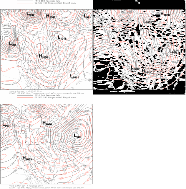
Winter '09 / '10 - ECMWF/s 'Happy New Year' Xmas Present or Coastal Teaser?

Arctic air everywhere.  Happy New Year!

Photobucket

Center of upper LOW progging farther S+W w/time ==> surface development @lower latitude.
Trof appears to take on a negative-tilt.

Fits the pattern.
Don't want it looking too good this far out.