Wednesday, January 09, 2013

Winter '12 / '13 - Stratospheric Sudden Warming: Watch #2

UPDATE #3
Current SSW event can now be classified as a major warming.  Temperatures have increased ~50°C in less than seven days AND zonally averaged winds @60°N have turned easterly.


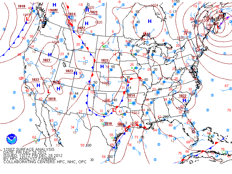
Max 10 mb (31,242m; ~50K') temperature @12z today was -22°C (-7.6°F) over Viljujsk...Russia (map).

Why is SSW matters...

Pronounced weakenings of the NH wintertime stratospheric polar vortex tend to be followed by episodes of anomalously low surface air temperatures and increased frequency of occurrence of extreme cold events throughout densely populated regions such as eastern North America, northern Europe, and eastern Asia that persist for ~2 months.
http://www.nwra.com/resumes/baldwin/pubs/Thompsonetal_2002.pdf

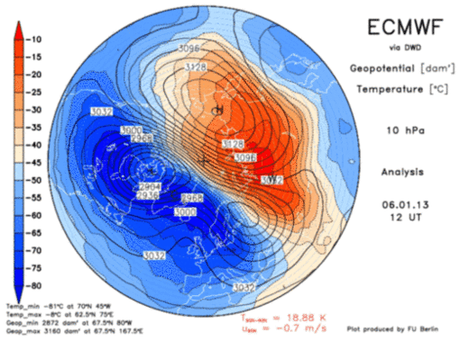
Pronounced weakening of the PV (cool colors) as it splits in two bya strong anticyclone advancing on 90°N...


10 mg height analysis courtesy JMA.


Warm colors indicate east wind.  Polar wind field along left edge of frame.  Anticyclonic circulation is strongest above 10 mb and extends to surface.  Blue action center near 30N @ 200 mb is the sub-tropical jet.

Height-Latitude Cross Section of Zonally Averaged Zonal Wind image courtesy JMA.

---
UPDATE #2 (7-JAN-13 @ 7:08 PM EST)

North- South 0° - 180W°
East - West 90°E - 90°W

Minor warming under way...evidenced by the sharp increase in temperature at 10 mb (> 25K) over the Pole in less than a week's time.  A 'major' warming classification requires the same rapid temperature increase and the PV to become easterly at 60°N at 10 mb or below.


Just a hint of the warming down to ~30 mb along seen on the right edge of the above image.


Not the wave flux above 100 mb...especially in the final frame...where the 'hot' colored vectors veer toward the pole indicating energy propagating from the troposphere into the poleward Ignorosphere.


ECMWF forecasts the PV to bifurcate and maintain that state through D+10 as anticyclone builds over 90N.  CW has it the anticyclone propagates to the surface in a few weeks where -AO becomes established.  Some unknown location in the mid-latitudes can probably expect a Mother lode of cold toward the end of January.

---
UPDATE #1 (30-DEC-12 @ 1:58 PM EST)
Strong anticyclone forecast at D+10 (blue region in upper right of frame).

Wednesday, January 02, 2013

Winter '12/ '13 - Arctic Oscillation: Is December A Leading Indicator?

UPDATE
December AO:  -1.749
Rank:  11th (17th percentile)

---
Original post date:  26-DEC-12 @6:31 PM EST

Little doubt DEC/s index will come in negative given the 30-day moving average stands at -1.965.

Does the sign of DEC/s AO have any predictive value?  The sign of NOV/s AO was shown to have predictive value for the sign meteorological winter/s (D-J-F) average AO.

The 2x2 contingency table of DEC/s AO index and JAN/s index shown below suggests there/s a strong association between the two...especially when DEC/s AO is < 0.

Each cell in the table shows the number of years where the sign of the DEC/s AO was associated with the sign of JAN/s AO.


When DEC/s AO is < 0...there/s an 82% chance the JAN/s average AO will also be negative. 

The table/s precision is 74%...where precision is the proportion of negative cases predicted correctly [a / (a + c)].  The probability of a 'false positive' (-AO forecast; + AO observed) is 36%.

Winter '12 / '13 - Arctic Oscillation: Day 31

Not sure what if anything it means but here/s the state of the AO on Day 31 of meteorological winter during its 63 year period-of-record


Blue line is the observed AO on 31-DEC.
Red line is a 9-point binomial filter.  The filter removes noise from the signal to highlight trends.

The 31-DEC-12 AO ranks 31th (52th percentile). 


Same idea for AO/s sister...the North Atlantic Oscillation (NAO).
The 31-DEC-12 NAO ranks 53th (84th percentile).

Winter '12 / '13 - Long Range Forecast: Farmer/s Almanac

Two Towers - New York
Alfred Stieglitz
OCT-1911

January 2013
1st-3rd. Showery, then clearing and cold. Wet for Mummers Day Parade in Philadelphia.
4th-7th. Storm sweeps across Pennsylvania and New York with gusty winds and heavy precipitation.
8th-11th. Blustery and colder; snow showers.
12th-15th. Mostly fair.
16th-19th. Wet, then fair and cold.
20th-23rd. Heavy snow (half foot or more) for New England; lighter amounts farther south.
24th-27th. Scattered flurries.
28th-31st. Sharp cold front brings rain and snow showers, then clearing and cold.

February 2013
1st-3rd. Fair.
4th-7th. A sharp cold front brings gusty winds, rain, and snow showers.
8th-11th. Unsettled; light snow and flurries.
12th-15th. Major Northeast snowstorm develops: some accumulations could exceed one foot; strong winds cause considerable blowing of snow.
16th-19th. Lingering snow showers, flurries.
20th-23rd. Blustery and cold.
24th-28th. A major storm over the ocean perhaps brushes the coast with light snow and gusty winds, then turning fair.

More...

Winter '12 / '13 - SOI: December


December/s SOI (Southern Oscillation Index) came in at -6 after three consecutive months where the index went above zero.

A negative SOI is associated with above normal sea surface temperatures (SST) in ENSO Region 3.4 in the tropical Pacific.  Sustained SOI < -8 indicates el Nino.

Weekly SST anomalies from Region 3.4 have been running a tenth or two below normal the past four weeks causing the 12-week moving average to fall to 0.18 (neutral-warm).


ENSO Region image courtesy CPC

Monday, December 31, 2012

Winter '12 / '13 - Storm #2: Final Results

1st - donsutherland1
SUMSQ:
77.41

SUMSQ Z:
-1.049

STP:
13.15
 (5)
TAE:
30.45
 (1)
AAE:
1.45
 (2)


2nd - Brad Yehl
SUMSQ:
78.27

SUMSQ Z:
-1.040

STP:
10.15
 (4)
TAE:
31.05
 (2)
AAE:
1.29
 (1)
3rd - snocat918
SUMSQ:
104.51

SUMSQ Z:
-0.752

STP:
7.55
 (3)
TAE:
39.55
 (5)
AAE:
1.72
 (4)


HM - Donald Rosenfeld
SUMSQ:
112.59

SUMSQ Z:
-0.663

STP:
1.10
 (1)
TAE:
40.20
 (6)
AAE:
1.83
 (6)


SUMSQ: sum of square errors
STP: storm-total precipitation error
TAE: total absolute error
AAE: average absolute error
(number):  category rank

Full forecast verification and summary at the Contest/s home page.

Sunday, December 30, 2012

Winter '12 / '13 - Storm #1: Final Results


1st - dryslot
SUMSQ:
112.98

SUMSQ Z:
-0.887

STP:
5.26
 (4)
TAE:
39.64
 (6)
AAE:
1.80
 (5)
2nd - herb@maws
SUMSQ:
119.42

SUMSQ Z:
-0.846

STP:
13.79
 (7)
TAE:
36.79
 (3)
AAE:
1.75
 (3)
3rd - Brad Yehl
SUMSQ:
213.38

SUMSQ Z:
-0.782

STP:
2.65
 (3)
TAE:
35.75
 (2)
AAE:
1.62
 (2)
HM - Donald Rosenfeld
SUMSQ:
140.87

SUMSQ Z:
-0.711

STP:
0.99
 (1)
TAE:
33.99
 (1)
AAE:
1.55
 (1)

SUMSQ: sum of square errors
STP: storm-total precipitation error
TAE: total absolute error
AAE: average absolute error
(number):  category rank

Full forecast verification and summary at the Contest/s web site.

Winter '12 / 13 - Storm #2: Preliminary Verification


Preliminary storm-total snowfalls for Saturday from CDUS41 and CXUS51 bulletins.

Several stations in the data table do not have SN:H2O reported b/c their liquid totals included mixed precipitation.

CON STP of 2.6" at 10:1 is suspect given surrounding amounts and much higher ratios.

---
Two new daily records.
SAT...29-DEC-12
BDR - 3.5" (3.1"; 1959)
IAD - 0.9" (0.3"; 1993)

---
Please report any errors and drop a link to the correct data in Comments.

Final results and storm summary Monday evening.

Saturday, December 29, 2012

Winter '12 / '13 - Storm #2: The Forecasts

Consensus for a southern NE and northern M-A event.


12 forecasters
3 Rookies...two of which issued their 1st forecast for Storm #2.

Welcome Kevinmyattwx and quagmireweathercentral!
Forecaster answer7 is now an Intern.


Forecasts are ranked by their storm-total precipitation (STP).
BLUE ==> 25th percentile.
RED ==> 75th percentile.
STP cells without color are between the 25th and 75th percentile.

Everyone/s station-by-station forecast at the Contest/s web site.

---

Slight amplification in the long-wave flow regime suggested by +PNA.  -AO getting the job done again as its sister index the +NAO offers more evidence of how unimportant she is to snowfall on the east coast.