Winter '18 / '19 - Predictive Value of NW Atlantic Ocean's SST Anomalies for Winter's Phase of the North Atlantic Oscillation
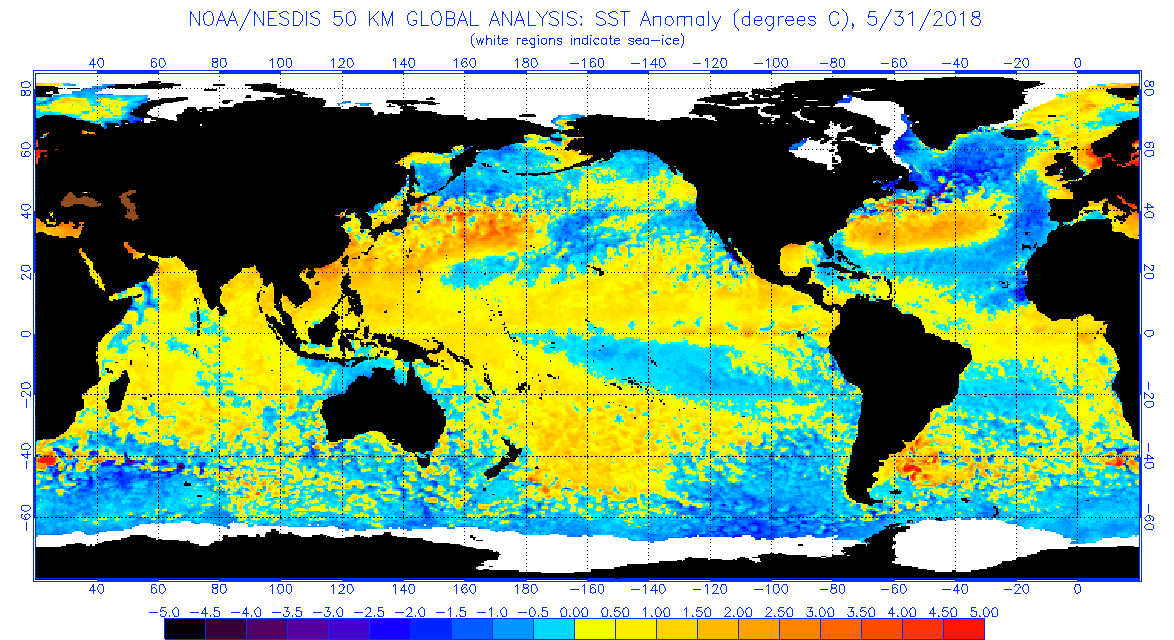
Up until a few years ago ... the UKMET office issued a long-lead forecast for the phase of the upcoming winter's North Atlantic Oscillation (NAO). The forecast was based on a statistically significant correlation between May's sea-surface temperature anomalies (SSTA) in the western Atlantic ocean (depicted in the image below left) and NAO's future D-J-F phase (as depicted in the Winter Z500 pattern image below right).

To apply this technique for Winter '18 / '19; take note of the SSTA pattern in the NW Atlantic at the end of MAY-18 shown below.
- Positive anomalies off the mid-Atlantic and NE coasts.
- Negative anomalies in the Labrador Sea off Greenland's southern coast.
- Positive anomalies north of Iceland in the Norwegian Sea.

Compare these anomalies with the 'May SST pattern' map.
See how well they align?
MET Office research concluded if May's SSTA aligns generally with the prediction pattern in the western Atlantic ocean ... then the expected dominant NAO state would be positive during the upcoming winter.
Above normal SST in the offshore waters of the NE coast ... below normal water temperatures SW
of Iceland ... and positive anomalies to the northeast point to a +NAO. When
the pattern is reversed a -NAO is forecast.
Based on May-18 SSTA ... the dominant NAO state prediction for Winter '18 / '19 is positive.
There's even empirical evidence the D-J-F NAO will average above zero if NOV's NAO index is greater than zero.
Winter-season forecasters hitching their collective wagons to the +ENSO state might could want to stop-and-consider the effect of the Northern Annual Modes on their outlooks.
---
Earlier post about UKMET NAO predictive research here.


