Showing posts sorted by relevance for query ukmet. Sort by date Show all posts

Tuesday, November 22, 2011

Winter '11 / '12 - The North Atlantic Oscillation and Sea Surface Temperatures

Conventional wisdom states it's next to impossible to skillfully forecast the state of the North Atlantic Oscillation (NAO) more than a week to ten days in advance.

Even that's a stretch given the generally low correlation between forecast and observed conditions.  The current ten-day and 14 day correlations are 0.72 and 0.55...respectively which means the forecast explains 52% and 30% of the NAO's variability.  There's some skill at ten-days...not so much at 14.

The UKMET Office produced an NAO winter-season forecast up until the fall of 2009.  It was based on sea surface temperature anomalies (SSTA) in the mid-Atlantic Ocean.  They claimed a 67% skill level.  It's no longer published...possibly b/c of recent controversies and adverse publicity surrounding their 'failure' to forecast the severity of the past two winters.

Image courtesy UKMET Office
"By taking the observed SST anomaly for May and calculating how it projects onto the predictor pattern we (ed:  UKMET Office) can make a prediction for the winter NAO.

"If the projection is positive (i.e., the anomaly pattern looks similar to the predictor pattern shown above) then the prediction is for a positive winter NAO.

"Conversely, if the observed May SST anomaly projects negatively onto the predictor pattern (i.e., it looks like the reverse of the predictor pattern) then we (ed:  UKMET Office) would predict a negative NAO."
---
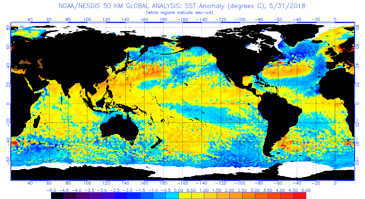
So...where were SSTAs lurking in the Atlantic this May?
What...if anything...might they predict about the state of Winter '11 / '12 NAO?

If you're rooting for Team NAO to come through and deliver a halfway decent winter...then you can't be happy about the positive-negative-positive SSTA pattern along the northwest rim of the Atlantic Ocean last May.

The observed pattern predicts low 500mb heights will prevail over Greenland this winter and therefore...a predominantly positive NAO.
---
More about SSTAs and the NAO during winter in a few days.

Friday, November 09, 2012

Winter '12 / '13 - North Atlantic Oscillation: Long-range Signals and Long-term Trends

Up until a few years ago...the UKMET office issued a long-lead forecast of the North Atlantic Oscillation's (NAO) phase for the upcoming winter.  The forecast was based on the correlation between May's sea-surface temperature anomalies (SSTA) in the western Atlantic ocean and the phase of the NAO.  Geo-potential height anomalies at 500 mb in the same general region were also found to have predictive value.

They claimed these correlations had predictive value ~67% of the time...a far cry better than the brain-dean CW about how seasonal NAO forecasting is unpossible.


If May's SSTA matches the pattern in the western Atlantic ocean...then a +NAO is expected to be the dominant state during the upcoming winter.  Above normal SST in the offshore waters of the NE coast...cold water SE of Iceland and warm anomalies to the northeast point toward a +NAO.  If the pattern is reversed...then a -NAO is forecast.

---
This year...May's SSTA were a good match to the anomaly pattern shown above off the NE coast (1) but not so much elsewhere (2,3).


Area 1...the offshore waters of the NE...+SSTAs ==> +NAO
Area 2...SW of Iceland...+SSTAs ==> -NAO
Area 3...NE of Iceland...-SST anomalies ==> -NAO

SSTAs offer a decidedly mixed signal.
---
At 500 mb anomalies for MAY-12...


Positive height anomalies over Greenland ==> -NAO
Positive height anomalies over western Europe ==> +NAO
The effect of a negative action center INVOF the Azores is unknown.
---
This winter's NAO signal based on the UKMET/s long-lead conceptual model is unambiguously ambiguous.

Sea-surface temperature anomalies off the NE coast suggest +NAO while SSTAs off the coast of Greenland suggest -NAO.  Height anomalies at 500 mb over Greenland signal -NAO and a + NAO over western Europe.  The effect of the Azores' strong negative signal is unknown.

Next up:  Analogs

---
Earlier posts about the UKMET NAO forecast here.

Saturday, November 03, 2018

Winter '18 / '19 - Predictive Value of NW Atlantic Ocean's SST Anomalies for Winter's Phase of the North Atlantic Oscillation

Up until a few years ago ... the UKMET office issued a long-lead forecast for the phase of the upcoming winter's North Atlantic Oscillation (NAO).  The forecast was based on a statistically significant correlation between May's sea-surface temperature anomalies (SSTA) in the western Atlantic ocean (depicted in the image below left) and NAO's future D-J-F phase (as depicted in the Winter Z500 pattern image below right).


To apply this technique for Winter '18 / '19; take note of the SSTA pattern in the NW Atlantic at the end of MAY-18 shown below.

- Positive anomalies off the mid-Atlantic and NE coasts.
- Negative anomalies in the Labrador Sea off Greenland's southern coast.
- Positive anomalies north of Iceland in the Norwegian Sea.

https://www.ospo.noaa.gov/data/sst/anomaly/2018/anomnight.5.31.2018.gif

Compare these anomalies with the 'May SST pattern' map.
See how well they align?

MET Office research concluded if May's SSTA aligns generally with the prediction pattern in the western Atlantic ocean ... then the expected dominant NAO state would be positive during the upcoming winter.

Above normal SST in the offshore waters of the NE coast ... below normal water temperatures SW of Iceland ... and positive anomalies to the northeast point to a +NAO.  When the pattern is reversed a -NAO is forecast.

Based on May-18 SSTA ... the dominant NAO state prediction for Winter '18 / '19 is positive.
There's even empirical evidence the D-J-F NAO will average above zero if NOV's NAO index is greater than zero.

Winter-season forecasters hitching their collective wagons to the +ENSO state might could want to stop-and-consider the effect of the Northern Annual Modes on their outlooks.

---
Earlier post about UKMET NAO predictive research here.

Thursday, February 26, 2009

Snow Storm #8: Preview Redux

Today/s 12z NWP solutions in strong agreement with their depiction of cyclogenesis along the SE CONUS coast on SUN.

The image loops today/s 72-hour forecasts from the 12z runs of the ECMWF... UKMET...GFS...and GEM.

The upper LOW isn/t all that cold; however...strong HIGH pressure parked over eastern Canada will be needed to maintain low-level cold air. Synoptics also suggest a threat for freezing rain...especially coastal stations in New England and the mid-Atlantic/s inland stations.

NAM time-height x-sections suggest ~9 stations could be in play...more than enough to get #8 finally off the ground. After a healthy pace during the first two months of winter...FEB has turned out to be a big disappointment. Not a single contest-worthy storm. Snowfall climatology favors FEB as prime-time for most mid-Atlantic stations.

Should this scenario still seem likley tomorrow...a call for forecasts will come Friday evening with an entry deadline several hours earlier than usual Saturday evening so as to include snowfall in Pennsylvania.

Monday, November 10, 2008

Eric Horst - Winter Outlook '08 / '09

In addition to asking Paul Knight...WJAC-TV also wanted to know what Eric Horst...founder of the Campus Weather Service and director of the Weather Information Center at Millersville University...thought about the upcoming winter in terms of...

"More / Less snow than average
Warmer / colder than average
More / Less snow than last year
Warmer / colder than last year
Timing / type of the bigger storms
Etc.
…and some reasoning behind the forecast."
Eric has a decidedly different take regarding ENSO...

"Regarding the winter outlook…as you surely know, we do NOT have a signal from ENSO. Last winter’s rapid ramp up of a strong La Nina was a clear signal for a milder and less-snowy winter in PA…and that of course panned out nicely. With a neutral ENSO this winter, there’s no clear signal…and as I like to say it’s therefore more of an “anything goes kind of winter.” You can research past neutral ENSO winters and find both above and below temp seasons and above and below snowfall seasons, as well as many near-normal seasons.

"So which way will this winter tip? I feel that’s hard to say, because the winter will be guided by more subtle, short-lived factors such as NAO (which biases somewhat in accordance to changing SSTs in the north Atlantic) and the EPO which plays off mid-latitude pacific patterns. So, these are the signals I’ll be watching in the months to come. Unfortunately, there’s no reliable way to forecast either Index. The UKmet folks do try to model NAO…and they are forecasting a “near-neutral” NAO overall. Of course, on any given week there can be major swings negative or positive. So, I think we’d be wise to track NAO and EPO this winter to make medium-range (5 – 15 day) forecasts; big storms tend to develop when the index flips, as we saw the past few days.

"The bottom line: this winter will almost certainly be snowier and colder than last winter (which won’t be hard for most parts of PA), but I see NO strong signal to forecast a much below temp or much above snowfall winter. That can of course happen—it only takes one big storm to push snowfall much above normal…in fact, the Poconos will likely be above normal based on yesterday’s big storm padding the numbers already! Anyway, my sense is that PA will see a near- to slightly below normal temp winter and near- to somewhat above-normal snowfall winter."
WJAC-TV reports California University of Pennsylvania declined to participate in their survey.

Monday, October 20, 2008

MET Office - NAO Forecast '08 / '09

The UKMET Office...the British version of the US NWS...produces a statistical NAO forecast for the upcoming winter.
The forecast for 500 mb heights is based on a analysis of observed and the 'predictor pattern' of SST anomalies in the northern Atlantic Ocean.
"By taking the observed SST anomaly for May (figure above) and calculating how it projects onto the predictor pattern we can make a prediction for the winter NAO. If the projection is positive (i.e. the anomaly pattern looks similar to the predictor pattern) then the prediction is for a positive winter NAO. Conversely, if the observed May SST anomaly projects negatively onto the predictor pattern (i.e. it looks like the reverse of the predictor pattern) then we would predict a negative NAO."
"The figure below shows that the predicted winter NAO index for 2008/9 is weakly positive at +0.1 with a standard error of ±1.0. The small amplitude of the predicted index relative to the error bar means that the NAO prediction this year provides little signal for below- or above-normal European winter temperatures or precipitation. However, the prediction is consistent with a cooler, drier winter over northern Europe as a whole than experienced in winter 2007/8, when the observed index was +1.6."

Note...however...last year/s prediction (-0.05) was essentially the same as this year/s and last year/s observed NAO was +1.6.
Move along. Not much skill here. At least not in the past few years.

Wednesday, December 06, 2006

NAO - MET Office Winter Forecast '06 / '07

The UKMET Office issued their Winter Forecast yesterday.

Temperature across Europe - slightly above climo with occasional cold outbreaks. In the UK, December is expected to be mild with colder temperatures during mid and late winter.

Sounds vaguely familiar.

Precipitation across Europe - equal chances for above or below normal. In the UK, they expect normal to slightly above normal.

Sounds like they/re expecting a +NAO to dominant this winter...which is au contraire to many US forecasters who 'see' the opposite as the most likely outcome.

The Brits have been torturing the NAO index in recent years in a dogged attempt to make it confess to what it knows about the coming winter. The MET Office claims their winter NAO forecasts...which are based on May/s SST anomalies in the NW Atlantic near Newfoundland... have a 66% accuracy regarding it/s sign.


May SST Pattern - Winter Z500 Pattern


May 2006 SST Anoms

Nothing negative about the correlated 5H pattern this season.

Friday, September 04, 2009

Winter '09 / '10 - NAO Forecast - MET Office

The UKMET Office...the British version of the US NWS...produces a statistical NAO forecast (reg. reqd.) for the upcoming winter.

The forecast for 500 mb heights is based on an analysis of observed and the 'predictor pattern' of SST anomalies in the northern Atlantic Ocean during the month of May.

"By taking the observed SST anomaly for May (figure at left) and calculating how it projects onto the predictor pattern we can make a prediction for the winter NAO. If the projection is positive (i.e. the anomaly pattern looks similar to the predictor pattern shown below) then the prediction is for a positive winter NAO. Conversely, if the observed May SST anomaly projects negatively onto the predictor pattern (i.e. it looks like the reverse of the predictor pattern) then we would predict a negative NAO."


There's a weakly negative statistical correlation between season-total snowfall in New England and the Mid-Atlantic regions and the NAO. This association is often mis-applied to individual storm systems -- if we could just get the NAO to turn negative...then we're more likely to get snow.

NAO forecast was quite good last year. Snow crows hope it's not as advertised this winter.