Sunday, February 12, 2012

Winter '11 / '12 - Snow Storm #2 - Fizzle

Update:
ORH measured 0.5"


No report from ORH at post-time.

Friday, February 10, 2012

Winter '11 / '12 - Snow Storm #2 - Call for Forecasts

UPDATE: 
'Call for Forecasts' CANCELLED.
---
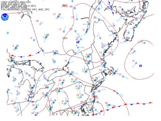
Looks to be more than enough snow potential along the northern edge of the precipitation shield to warrant a contest...especially this winter when contest-worthy storms have be MIA.

JFK Airport
10-FEB-69
The contest may be canceled prior to the deadline if NWP indicates a fizzling event.
---
Forecast element: storm-total snowfall
Deadline for entries: 10:30 PM EST FRI...10-FEB-12

Verification period begins: 12:01 AM SAT...11-FEB-12
Verification period ends: 11:59 PM SAT...11-FEB-12

Enter your forecast at the Contest's home page here.

Follow the link from 'Enter Storm Forecast.'

---
As always...there/s no cost...or fee...or advertising...or annoying requests for personal information to enter a forecast. It's just a fun exercise among winter wx enthusiasts to see who can make the best synoptic-scale snowfall forecast.

If you are issuing your first forecast this winter...or you entered the 'season-total' forecast contest...you/ll need to create an account (user name / password / valid e-mail...if you want a copy of your forecast sent to your Inbox).

Want to be notified via e-mail when a 'Call for Forecasts' is issued?
Send your request to newx at newx-forecasts dot com.

Wednesday, February 08, 2012

Winter '11 / '12 - Meteorological Winter - Month Two

NWS finally got around to issuing their month-end climo bulletins for NEWxSFC forecast stations.

Here's the state of this sad...sad winter.
Northern New England stations barely holding their own.  Most in the top third are half to just under two-thirds their climo total for December and Janaury.

Short of Superstorm '93 seqel...all of the middle Atlantic is down for the count.
Normal season-totals aren't very high to begin with...so all it would take is one good...slow moving coastal to make up current deficits.


Climo columns are the summed monthly totals for DEC and JAN.


Favorite teleconnections finally heading in the right direction over the last 10 days of the month.

Thursday, January 26, 2012

Winter '11 / '12 - VCP32 - Commiting Suicide


It's been that kinda winter for snow crows.

Monday, January 23, 2012

Winter '11 / '12 - Snow Storm #1 - Final Results

Mid-Atlantic/s warm and runny 'nose-of-doom'
herb@maws
SUMSQ:35.15
SUMSQ Z:-1.012
STP:5.80 (2)
TAE:19.60 (1)
AAE:0.82 (1)
donsutherland1
SUMSQ:39.49
SUMSQ Z:-0.900
STP:11.55 (4)
TAE:19.75 (2)
AAE:0.82 (2)
Brad Yehl
SUMSQ:45.16
SUMSQ Z:-0.752
STP:1.85 (1)
TAE:23.65 (3)
AAE:0.99 (3)
weatherT
SUMSQ:61.20
SUMSQ Z:-0.336
STP:13.29 (5)
TAE:27.49 (5)
AAE:1.15 (5)
SUMSQ: sum of square errors
STP: storm-total precipitation error
TAE: total absolute error
AAE: average absolute error
(number):  category rank

Full forecast verification and summary at the Contest/s web site.


Sunday, January 22, 2012

Winter '11 / '12 - Outlooks

From CPC (0.5 month lead)...


La Nina continuing to hold sway over the forecast area for the last month of meteorological winter.

More winter Outlooks after the jump.

Winter '11 / '12 - Snow Storm #1 - Preliminary Verification

Preliminary storm-total snowfalls for Saturday from CDUS41...CXUS51...and PNS...as of noon Sunday.

The storm-total snowfall for HYA is an estimate derived from vicinity reports in Barnstable county carried in the PNSBOX bulletin.

Several stations in the data table do not have SN:H2O reported b/c their liquid totals included mixed precipitation.

---
Two new daily records.
Saturday...21-JAN-12
PVD - 7.6" (6.6"; 1976)
BDR - 6.2" (6"; 2001)

Please report any errors and drop a link to the correct data in Comments.

Final results and storm summary Monday evening.

Saturday, January 21, 2012

Winter '11 / '12 - Snow Storm #1 - The Forecasts

Welcome back everyone.
The kick-off event was a l-o-n-g time coming.  Here/s hoping it/s not the last!

Eight entries.
6 Senior forecasters...including NEWxSFC/s Chief forecaster donsutherland1
1 Journeyman
1 Intern

Congratulations to...
WeatherT on being promoted to Senior forecaster
Roger Smith on being promoted to Journeyman forecaster
Brad Yehl on being promoted to Intern forecaster

NEWxSFC/s Chief forecaster is the winner of last year/s 'storm-total' contest.
Senior forecasters have a minimum of three years experience.
Journeyman forecasters have two years experience.
Intern forecasters have one year experience.
Rookie forecasters are rookies.

---
All forecasts have been posted to the Contest/s web site.
Follow the 'Winter '11 / '12 Storm Contest Forecasts  Storm #1' link.

Entries are ranked by 'storm total' forecast.


Large range of expected storm-total snowfall...
Min: 30" (Roger Smith)
Max: 78" (Mitchel Volk)
Avg: 56"
Median: 54"
STD: 15"


Consensus heavy snowfall (+4") axis expected to fall inside HYA - PVD - BDR - ABE - MDT - EWR - BDL - HYA.


Little help from teleconnections.

---
Thanks to Donald Rosenfeld for hosting the Contest web site again this year.  Donald/s continued support has been instrumental in the keeping the annual NEWxSFC going for many years.

Thursday, January 19, 2012

Winter '11 / '12 - Snow Storm #1 - Call for Forecasts

c.1890
Today/s 12z progs indicating a lot of forecast stations in the mid-Atlantic and southern New England are in line to get snowed upon but there may not be all that much of it.

A weak frontal wave rising out of the OH-TN river valley early Saturday morning will throw Atlantic moisture atop an arctic air mass parked over SE Canada.

Looks to be a borderline nuisance event but at this point in a rather disappointing season...we/ll take it.


The contest may be canceled prior to the deadline if NWP indicates a fizzling event.

---
Forecast element: storm-total snowfall

Deadline for entries: 10:30 PM EST FRI...20-JAN-12

Verification period begins: 12:01 AM SAT...21-JAN-12
Verification period ends: 11:59 PM SAT...21-JAN-12

Enter your forecast at the Contest's home page here.
Follow the link from 'Enter Storm Forecast.'

---
As always...there/s no cost...or fee...or advertising...or annoying requests for personal information to enter a forecast. It's just a fun exercise among winter wx enthusiasts to see who can make the best synoptic-scale snowfall forecast.

If you are issuing your first forecast this winter...or you entered the 'season-total' forecast contest...you/ll need to create an account (user name / password / valid e-mail...if you want a copy of your forecast sent to your Inbox).

Want to be notified via e-mail when a 'Call for Forecasts' is issued?
Send your request to newx at newx-forecasts dot com.

Tuesday, January 17, 2012

Winter '11 / '12 - Season Opener?

GooFuS has been busy pumping out promising progs with shiny stellar dendrites dangling over the forecast area this weekend for what could turn out to be this winter/s season opener contest-worthy snow storm.


The storm is forecast to organize as a frontal wave over the lower MS river valley then reaches the east coast along the mid-Atlantic positioned below a weak but building arctic HIGH over the Canadian Maritime provinces late Saturday.


There's a icy cold column rich with moisture and fat bulge of WAA in the 700-800 mb layer over ALB @105hr from today/s 12z initialization.  Surface layer is an arctic air mass with temperature and dew point in the teens despite low level easterlies.

For all the talk about how critically important it is for the North Atlantic Oscillation (NAO) to be in a negative state for decent snowfalls over the forecast area...it'll be the Arctic Oscillation (AO) going negative (-1.313 @post-time) and riding to the rescue (again).

---
A 'Call for Forecasts' will be issued Thursday evening if the forecast continues its current trend.  The deadline would be Friday @10:30 PM EST.