Thursday, February 05, 2009

Sudden Stratospheric Warming - Update

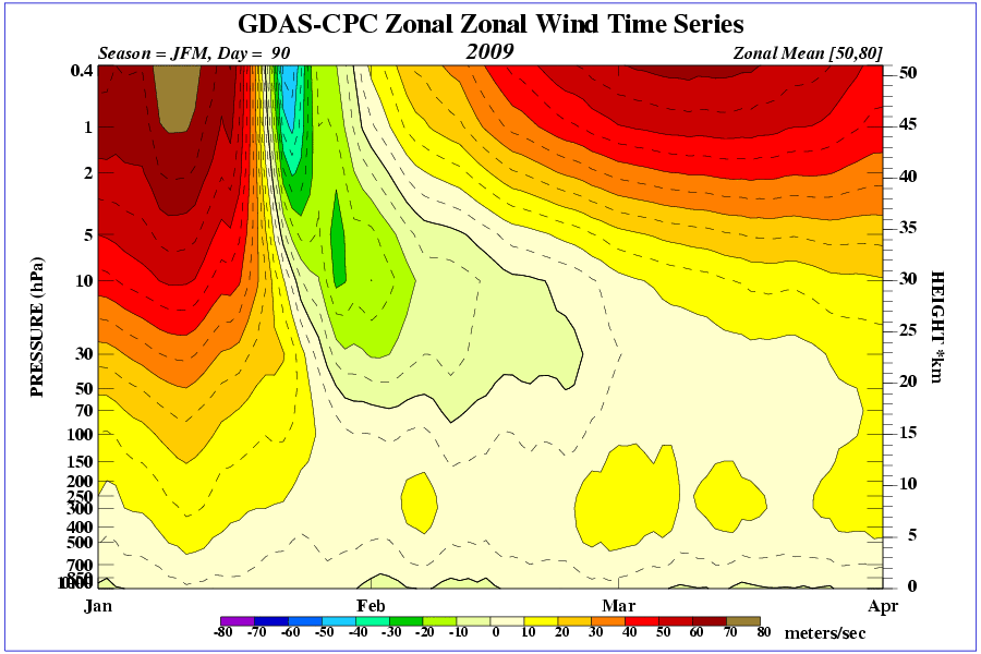
A negative zonal wind is an east wind...flowing into the board. It reflects the anti-cyclonic circulation aloft...and at post time...there/s evidence of a polar surface HIGH...as well.


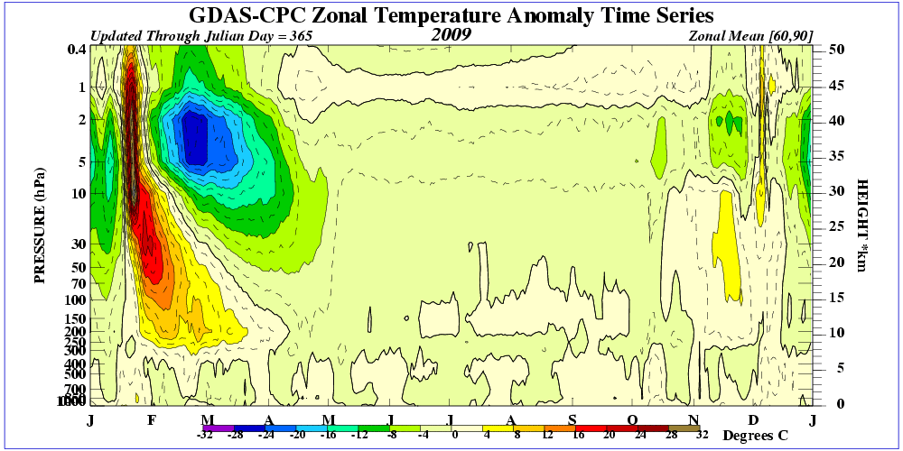
Temperature time-height section reveals the depth of stratospheric warming anomaly has reached ~300 mb...a reasonable approximation of the tropopause. Wiki.


SSW can lead to arctic outbreaks ~4 weeks after the event...which would happen around the third week of February. The ECMWF puts the cold air over the prime meridian in 10 days. Question is...where will the brunt of the cold set up in the days to follow and will significant disturbed weather ensue?

With a low tropopause height...tropopause folding could cause a surface cyclone to really spin-up as stratospheric vorticty becomes entrained into the storm complex.

Wednesday, February 04, 2009

NOAM Temperature Departures - January '09


The negative temperature departures observed in December sagged south and east from south-central Canada into the Great Lakes region and New England in January. Warm anomalies switched coasts in response to higher 500 mb geo-heights in the west and lower heights in the east along the predominant storm track. A number of high-profile seasonal forecasts expected mild temperatures in the east...highlighting the difficulty of beating the house.


Positive precipitation departures were observed over Canada/a west coast and along the spine of the central Appalachia.


Cumulative temperature and precipitation anomalies...season-to-date.


Plots courtesy ESRL - Physical Sciences Division

Tuesday, February 03, 2009

Snowfall Summary - January '09

January/s storm track continued to favor New England/s coastal and piedmont stations.

Concord (CON)...ranked first among all contest forecast stations...measured 186% of their monthly normal (17.8")...just shy of the 193% relative to normal snowfall observed in December. January/s 33.1" snowfall is 57% of their total winter snowfall (D-J-F-M). So far this winter...CON has 60.7" in the snow bank.

Boston (BOS) was second again in January...with 185% of normal monthly snowfall (12.8"). Boston ranked second in December with 316% of normal (8"). 58% of their normal winter snowfall occurred in Janaury. BOS two-month total stands @ 49".

Other notable monthly snowfall were Bridgeport (BDR) with 13.7" (183% monthly normal) and Bangor (BGR) with 175%.

Fifteen stations observed more than their normal monthly snowfall for January...including Raleigh (RDU) @ 125%.

Biggest losers were in the mid-Atlantic region again this month...and as was the case all of last season.

Green => Top 25%
Red => Bottom 25%

WFO Monthly/Daily Climate Data

NCDC Period-of-Record Snowfall Climatology

Monday, February 02, 2009

Sunday, February 01, 2009

Interim Standings

After seven snow storms... donsutherland1 holds the lead... shanabe moves back into second...and Donald Rosenfeld...hot off two straight wins...advances to third.

Several forecasters ranked in previous Interim Standings had not entered at least five forecasts and were not eligible for this summary under the ‘two-thirds’ rule.

Full interim forecaster error statistics table and charts here.

Forecaster storm summary data here.

SUMSQ errors for each contest snow storm are normalized with a 'Z-score'...then averaged to compute the standings. Forecasters who have entered at least 2/3 of all snow storm contests are included in the standings.

If a forecaster has participated in more than two-thirds of all snow storm contests...then Z-scores from two-thirds of their best forecasts are used to calculate Interim and Final standings. Same idea as dropping the lowest quiz score before the final grade is computed.

Previous Interim summary here.

Saturday, January 31, 2009

Snow Storm #8: Preview

(updated below - Update II - Update III)

Wowser!

Storm 8 being loaded into the chamber with at least six weeks of winter to go! Could easily be 12+ contest-worthy storms this season...a NEWxSFC record.

Storm 8/s 'Call for Forecasts' may be issued SUN evening...if current model solutions and trends continue. Interesting event unfolding with a number of stations poised to measure wrap-around / comma head accumulations.

Long-wave amplitude forecast to increase rapidly along with shortening wave-lenght...but the flow regime is progressive. HPC decidedly cool to the idea in this afternoon/s 'Heavy snow / Icing' discussion of a winter storm for the east coast...but what do they know?

Today/s 12z NAM and GooFuS flock southern forecast stations beginning late in the day on MON and over most stations on into TUE.

A '2 to 3' hour earlier than usual 'deadline for entries' on MON is being considered to capture snowfall expected over southern forecast stations MON evening. Otherwise...the deadline would have to be SUN evening...which is a long 'a-double scribble' leadtime...given the main event looks to be TUE.

Image: MAR 1888 Blizzard...Newburgh...NY

UPDATE
02/01/00z progs are manna from heaven. NWP puts PHL underneath the crystal factory for 24-hours. Not that it/ll actually happen. Just saying.

UPDATE II
02/01/12z progs presenting quite a conundrum. NAM solutions still GO for Storm 8 even though the heaviest precipitation axis has shifted east.

GooFuS puts the storm several hundred miles farther east with no snow depicted for the east coast. 12z GooFuS a significant departure from its 00z and 06z solutions.

Will evaluate 18z runs and proceed from there. A 'Call for Forecasts' is still expected later today with the standard 10:30 PM deadline; although Contest #8 could be canceled on MON if 02/02/00z/12z model runs push the system well offshore.

Cancellation announcement...if required...will be made on the web log and StormVista...not via e-mail.

UPDATE III
18z runs of NAM and GFS in good agreement that Storm 8 will not happen TUE / WED.

Friday, January 30, 2009

VCP 32 - Call It A Single

Snow Storm #7: Results

Senior forecaster Donald Rosenfeld makes it two in a row having issued the best synoptic-scale forecast for NEWxSFC/s seventh snow storm. His 25 station forecasts verified with 56.4 SUMSQ error points (Z-Score = -1.318)...which was a 47% improvement over the average error of 106".

He hit the trifecta...placing first in Total Absolute Error and Average Absolute Error.
Total Absolute Error: 28" (29% better than average)
Average Absolute Error: 1.12" (29% better than average)

Donald Rosenfeld/s forecast had the lowest station errors @ PWM BDR ALB BGM MDT BWI and perfect forecast @ BDR.

Congratulations Donald Rosenfeld!

Donald Rosenfeld wins one FREE month of StormVista GOLD for his forecasting acumen.

2nd Place: skiGirl (57.7"; -1.283)
3rd Place: shanabe (60.6"; -1.205)
Honorable Mention: Raven (68.2"; -1.003)

Full forecast verification and results summary here.

Thursday, January 29, 2009

Snow Storm #7: Preliminary Verification

Preliminary storm-total snowfalls for Tuesday and Wednesday from CDUS41...PNS...and CF6 bulletins.

Two new daily records.
BTV: 9.1" (5.3"; 1958)
BGM: 5.9" (5.1"; 2004)

HYA STP estimated from METAR 6-group data @ 10:1 in good agreement with vicinity reports carried in BOSPNS.

Please report errors in Remarks.
Final results and storm summary Friday evening.

Wednesday, January 28, 2009

Sudden Stratospheric Warming - Full On


Full-blown SSW underway with a reversal of the 10 mb wind extending below 60°N.

Broke through 50 and 70 mb...heading for 100.