Cosgrove the Examiner
 Blogging as Houston/s Weather Examiner.
Oriented toward KIAH / KHOU / KEFD / KGLS weather. Same detailed analysis...graphics..and imagery as his weekly newsletter (which is posted...too).
Blogging as Houston/s Weather Examiner.
Oriented toward KIAH / KHOU / KEFD / KGLS weather. Same detailed analysis...graphics..and imagery as his weekly newsletter (which is posted...too).

 ECMWF up to its old tricks...again?
Last TUE/s prog has a similar look to today/s 12z offering. An arctic HIGH pushing a strong cold front into the northern Gulf states where a low-latitude LOW would form and leave a deep carpet of snow in its wake as it climbed the coast.
So...how/d that turn out?
Only a handful of stations located in the extreme northern portions of the forecast area saw any snow. BGR observed +16"...CAR 10"...BTV 8"...CON ~8"...and PWM 7.8". Not all that far away from the action center...ORH measured 1.8".
Hoping for a better outcome this time and the start of a late winter rally. Set-up is not yet perfect...which is a good sign at this distance from VT. Today/s model run forecast the LOW to hug the coast and flood the zone with warm maritime air...all but killing snow chances for all but those stations farthest inland.
As for GooFuS...well...it lived up to its namesake.
 (updated below - Update2)
Originally posted MON...16 FEb 2009
12z progs were not at all encouraging.
Their portrayal of the storm complex continued essentially as a cold rain-maker for much of the forecast area with a sliver of decent snows falling beneath the northern edge of the precipitation shield.
Only four...maybe five...stations appear to be good candidates for more than a nuisance snowfall late Wednesday into Thursday. Favorable antecedent arctic air mass with dew points in the teens...breaks down quickly with the on-set of widespread veering...SE-to-SW wind profiles which are expected to dominant the storm environment.
GooFuS depicts better chances in the medium range with another potential forecasting opportunity next weekend.
Snow storm #8 awaits another day.
UPDATE:
02/17/00z progs indicate little...if any significant change to the 12z suite of solutions other than to delay on-set of precipitation by ~3 hrs at most forecast stations. Initially cold boundary layers warm to above freezing in response to unfavorable warm air advection vertical wind profiles which strongly suggest little...if any potential for a contest-worthy storm.
UPDATE2:
Verification of US model guidance of expected snowfall over the forecast area was +/-reasonable...
Storm Total Precipitation (inches observed)
CON - 7"
CAR - 4.7"
BGM - 3.8"
PWM - 3.5"
BGR - 3.4"
BTV - 2.1"
ALB - 2.1"
ORH - incomplete data (>= 2.3")
Elsewhere...plenty-o-trace amounts and < 1" reports.
Another good fall for CON...so...what/s up with that...anyway?
74" YTD. +31" departure.
Same time last year? 88"!
CON/s '08 total snowfall barely set an all-time record. LR progs suggest little change in established storm track...so more snow to come. Winter '09 could very well make it into the Top-10.
Image: Niagara Falls
 What could portend the start of a late winter rally and extra innings into March...the global models today were again dangling shiny objects before our eyes in their medium range forecasts.
Today/s ECMWF depicts an amplifying long-wave pattern over the CONUS beginning in a few days...with low-latitude cyclogenesis occurring ahead of a positively-tilted trof...and a potent nor'easter attending arctic HIGH pressure in the chamber for the last week of meteorological winter.
GooFuS offering up a similar idea...albiet a different evolution...as well.
Last snowfall forecasting event was almost three weeks ago. High time for another.
Once the storm passes...NWP suggests another arctic outbreak in the offing. Note the deep-layer easterlies at high latitude (negative zonal wind (u) at 500 mb ==> flow into the board)...evidence of a very weak / non-existent polar vortex...and an easterly arctic jet at 10 m/s...both of which indicate favorable conditions for an arctic outbreak into the mid-latitudes.
Is this the manifestation to the sudden warming of the stratosphere observed at the end of January? If so...the timing would be right on schedule.
Also interesting is the ~10 m/s west wind over the equator in the 30 / 50 mb layer...evidence of QBO-west maintaining its strength.


The predominant storm track this winter has been up the spine of the Appalachian Mountains with a secondary axis established in DEC a bit farther north and west from MO through MI. NWP has been advertising a change in recent runs...shifting the axis to the south and east...possibly the result of a robust -NAO state suppressing the storm track toward lower latitudes and offering the prospect of winter weather for the snow-starved mid-Atlantic region. The forecast for change dove-tails nicely with the climatological peak for snowfall in this area.
The first...and weakest...in a series of waves is progged to move through the southeastern states this weekend...primarily as a rain maker with some snow under the northern edge of the precipitation shield...followed by a second...stronger LOW southern portions of the mid-Atlantic early next week...followed by another... stronger wave a few days later. Going beyond that is getting deep into fantasy-land; however...the models currently show two more storms to round out the month.
Trends have shown better cold in the lowest layers and HIGH pressure positioned north of some surface LOWs. The fact that the models aren/t showing 'perfect' setups at this time-range is all the more reason to be optimistic.
While we wait for events to unfold...give a read to the post by Baltimore Sun/s Frank Roylance about the historic Blizzard of FEB 10...1899.
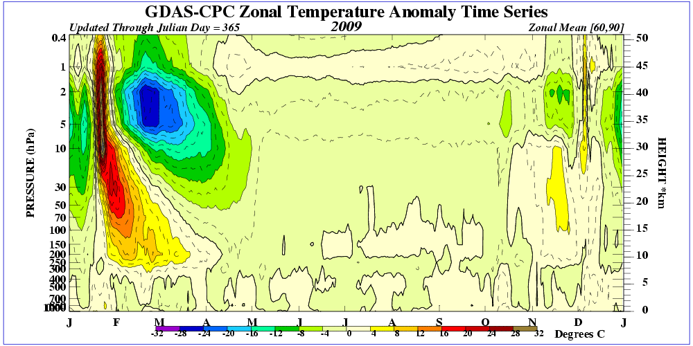
 Vortex reversal @ 10 mb was observed around JAN 27. Easterlies propagated steadily through 30...50...70...and close to 100 mb at post time. Warming has reached the tropopause near 300 mb.
Given there/s ~3-4 week lag between SSW-onset and its effects affecting the troposphere...LR progs are beginning to suggest the magnitude of the cold mother lode and the location where it will be observed.
Note the cold temperatures at 90°N in the D+10 latitude-height cross section. Top-o-world 1000 mb temperature -30°C! (-22°F) Coldest forecast temperature this winter. The warm bubble over 90°N @ 200 mb is the remnant of descending warm stratospheric air. Note the slope of the temperature gradient between 80°N and 90°N near 500 mb...evidence of an arctic jet.  The North Atlantic Oscillation (NAO) plunges...accordingly. 5 to 7 standard deviations below normal. Wowser! Should NAO come anywhere near those levels...it would be abso-fookin' historic. The lowest daily NAO value from a CPC dataset beginning in 1950 is -3.254.
The always reliable D+14 GooFuS blocking forecast suggests mega-blocking over Baffin Bay / Greenland....with significant winter weather implications for the eastern CONUS.
Apparently...Meteorlogix in Woburn...MA didn't get the memo until today.
From the JAN 28th edition of the Nashua Telegraph...Different story today...
"I do not see significant changes in the overall pattern we've had," Doug Webster of Hudson, senior meteorologist with Meteorlogix said.
If that's the bad news for the rest of winter, the good news is that Webster doesn't see us having another "severe cold snap" like the one that hit last week."
"The outlook for the remainder of the winter and early spring could hinge on recent events many miles above the polar landscape. During the end of January, an event known as Sudden Stratospheric Warming took place.
[...]
"Past history (ed. Is there any onther kind?) shows that when strong SSW occurs, wintry weather expands southward into the mid latitudes around the globe for a one- to two-month period.
[...]
"Given these possibilities, wintry weather could again become a fairly big story across much of the nation later this winter and into the spring.
"Past research (ed. Is there any other kind?) shows the lag time for the start of the more wintry weather regime is apparently on the order of two to three weeks after the SSW event. So enjoy the milder weather of the next week or so, because winter may return with some force during the second half of February and beyond."


 Posts
All Comments
Posts
All Comments