Coastal Teaser #2 - One Step Closer
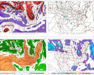
For your consideration - 00z 12/15 @ 156 HRS
Baggy...negative mid-lvl trof and a Miller 'B'. More than one system this fall has plunked a large luggie of cold air deep into the lower latitudes and coughed up a strong coastal cyclone. Interesting change depicted in the PAC NW where progged amplitude of LW is increasing and the coast-to-coast wave length is shortening. Will need 2m temps to get on-board.


2 comments:
Meteo Q - I see the mid-level trough depicted on the 500 & 700 mb panels - but what makes this trough "baggy"? Is it the wek looking shape of the mid level height lines or the surface pressure lines?
Shillelagh...
In this case, bagginess is depicted as the large separation between geo-potential height lines over the upper mid-west / GL region.
Bagginess in the UA field(s) suggests the potential for a closed upr low to form...which in this case...b/c of its location... would produce rapid coastal cyclogenesis through the 'self development' process as described by Sutcliff.
Bagginess...when depicted in the sfc pressure field...suggests a likely location where a new LOW will form.
TQ
Post a Comment